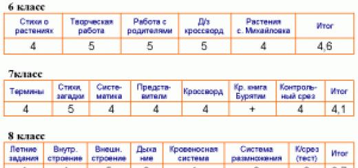
Lesson 7 8th grade Krasulina N.V.
Topic: Land and sea borders of Russia.
The purpose of the lesson:
Know the relationship between sea and land borders, the features and significance of land borders and sea borders of Russia.
Be able to work with a contour map, with text and illustrative materials from the textbook.
Means of education: textbook text, atlas maps, contour map.
During the classes:
I. Organization.
II. Repetition of learned material.
Give examples different types borders: new, integration, connecting, transparent, barrier, conflict, safe.
Which natural borders of Russia have the greatest extent?
What is a state border?
Which border does Russia have more: sea or land?
III. Learning new material.
Before Russia recognized the existence of borders with 16 states: , , , , , , , , , , , , , , And . After Russia recognized the states And Russia recognizes the existence of borders with 18 states . The length of the Russian border is 60,932 km.
Exercise:
Fill the table
Countries with only land borders
Countries with only maritime borders
Countries with which land and sea borders
Teacher's word:
There are 54 seas on Earth. Our country is washed by 13, of which 12 belong to the Moscow Region basin, and the Caspian Sea belongs to the internal closed basin. The largest and deepest sea washing the shores of Russia is the Bering Sea (area 2,315 thousand sq. km, average depth - more than 1,500 m, maximum - 5,500 m). the smallest and shallowest is Azovskoe (area - 39 thousand sq. km., average depth - about 8 m, maximum 15 m). The warmest sea is the Black Sea, the coldest is the Chukotka Sea, the saltiest is the Japanese Sea.
All seas are very diverse and natural conditions, both in terms of natural resources, and in terms of the degree of their study and development.
Exercise:
Determine whether the seas belong to the basins: BTO, BAO, BSLO, BVS
Teacher:
All seas are divided into 2 groups:
Marginal sea - This is a sea adjacent to the mainland, and weakly separated from the ocean by peninsulas and islands.
Inland sea – This is a sea that protrudes deeply into the land and communicates with the ocean through straits.
general characteristics seas:
The position of the seas relative to the ocean (free communication with the oceans of the Arctic Ocean and the Arctic Ocean, weak influence of the AO);
Different depths of the seas (the shallowest on the mainland shallows, the deepest seas TO);
Insignificant ‰ of the seas of the Arctic Ocean compared to the seas of more southern latitudes.
Environmental problems of the seas.
Exercise:
On contour map sign all the seas washing the shores of Russia
According to the plan, characterize 2 seas - the Kara and Okhotsk.
Plan Features:
FG position of the sea (belonging to the basin, internal or marginal).
Rugged coastline, peninsula, island.
Depth (average, maximum).
Climate features, temperature conditions.
Flora and fauna.
Meaning in life and economic activity of people.
Ecological problems.
III. Consolidation of the studied material.
Characteristics of the Kara Sea:
Arctic Ocean, marginal, protruding into the land.
Rugged, Ob Bay, Yamal village, Gdansk Peninsula, about. New Earth, Severnaya Zemlya, Vilkitsky Ave., Karskie Vorota Ave., o. Vaygach, o. White.
Depth 200-1000 m (continental shelf).
Harsh climate. Slight evaporation, January temperature - 24, July temperature - 0 + 8.
Walrus, polar bear, eider, goose, pike, burbot, sturgeon, whitefish, halibut.
Fishing, northern sea route.
River pollution, Nuclear pollution, soil degradation.
Characteristics of the Sea of Okhotsk.
THAT, marginal, protruding into the land.
Slightly rugged coastline, hall. Shelikhova, Fr. Sakhalin, Shantar Islands, Kamchatka Peninsula.
Depth 200-4000 m.
Salinity increases closer to the equator, January temperature -8 -45, July temperature + 8.
Sea otter, fur seal, pollock, salmon.
Fishing, northern sea route, territory protection.
Pollution of rivers and seas, deforestation, pollution between the mainland and the island. Sakhalin, oil pollution.
V. Homework.
Ex.6, pp. pp. 33 – 38.
State border- a line and a vertical surface passing along this line that define the limits of the state territory (land, water, subsoil and airspace) of the country, that is, the spatial limit of the action of state sovereignty.
Types of natural boundaries:
1. Lines separating the land territory of one state from adjacent territory of another state are state border on land. Land boundaries are preferably drawn along characteristic points, relief lines or clearly visible landmarks. They can be rivers, mountains, etc. Such boundaries are clearly visible and cause less misunderstanding.
2. Lines dividing territorial waters from waters open sea, that is, the lines of the outer limit of territorial waters, as well as the lines delimiting the territorial waters between two neighboring states, are maritime state borders. The maritime boundaries coincide with the external boundaries of the territorial waters. In accordance with international law, Russia has established a 12-mile width for these waters. In Russia, the length of sea borders is over 40 thousand km.
3. An imaginary surface passing along the state border line perpendicularly earth's surface, serves border of the airspace of the relevant state.
Types of boundaries according to the method of their determination:
Orographic boundary- a line drawn along natural boundaries taking into account the terrain, mainly along a mountain watershed and river beds.
geometric border crosses the area without taking into account its relief (bypassing populated areas).
Geographic line goes through certain geographical coordinates(may coincide with a parallel or meridian). Geographic boundaries drawn along parallels and meridians are found in Africa and America, where they were established by the metropolitan states for the colonies.
Economic boundaries.
The largest role among them is played by contact boundaries, which connect Russia with neighboring countries via transport routes. They are divided into connecting, which have a major role in foreign trade Russia (western borders of Russia), and integration.
An example of an integration border is the border with Belarus, with which ties are strengthened, goods are freely transported, and people move.
Many borders with former republics of the USSR "transparent", i.e. unguarded, poorly secured by customs institutions, are the former administrative borders with Ukraine and Kazakhstan.
At the same time, they highlight barrier borders, through which economic ties are difficult either due to natural obstacles (high mountains), or due to state-established regimes (obstacles). There are barrier borders alienating and filtering.
Geopolitical boundaries take into account relations between countries. At the end of the 30s. XX century the western border of the USSR was confrontational. Troops were concentrated on both sides. Today, due to a number of conflicts, the border in the south can be called a conflict border.
WITH legal point vision boundaries may be legitimate(legal, determined by government treaties) and conditional, which still need to be clarified by concluding the relevant agreements. Many borders of Russia are still conditional.
Historical boundaries- the boundaries within which the country once lay.
Based on origin and duration of existence state borders, they can be divided into two categories: antecedent and subsequent. Borders precede the eventual settlement and development of the regions they surround. An example of this type of border is the border between Canada and the United States, which was drawn along the 49th parallel in the period 1782-1846. and which divided very sparsely populated territories. Subsequent boundaries are the opposite of antecedent boundaries in the sense that they are drawn after the territory has been settled. An example here is the borders between European countries.
End of work -
This topic belongs to the section:
Basic attributes and functions of the state
The UN.. the UN is an international organization created to maintain and strengthen.. unrecognized states is the general name for regions that have declared themselves sovereign states..
If you need additional material on this topic, or you did not find what you were looking for, we recommend using the search in our database of works:
What will we do with the received material:
If this material was useful to you, you can save it to your page on social networks:
| Tweet |
All topics in this section:
Basic attributes and functions of the state
The central institution of the political system of society is the state. The state is an organization of political power that promotes the preferential implementation of specific
Main attributes of the state
Territory is the material basis of the state, the space over which its jurisdiction extends. Population – the totality of people living in the territory of a given state and subordinates
List of unrecognized and partially recognized states
1. Partially recognized states that actually control their territory - the Turkish Republic of Northern Cyprus, proclaimed after the invasion of Turkish armed forces
Form of government
The form of government is considered as the organization of the state, which includes the order of formation of supreme and local government bodies and the order of relationships between them. Forms of government in
Monarchies (other republics)
Asia: 1. Bahrain (kingdom) was an Emirate until 2002 2. Brunei (sultanate) the sultan has ruled for 45 years. Informally the richest person on the globe 3. Nepal (for a long time was koro
Form of government
Form government structure represents internal structure state, its division into component parts - administrative-territorial units, autonomous political entities
Territory and borders of the country
Territory is the place where the state is located. Largest countries: 1. Russia 17,075,400 sq. km After the collapse Soviet Union, Russia, former
Delimitation and demarcation of borders
There are two main stages in establishing a state border - delimitation and demarcation. 1. Delimitation is a determination (by agreement between the rights
EU – 27 countries, NATO – 28
European Union: economic and political union of 27 European states. Aimed at regional integration, the Union was legally enshrined in the Maastricht Treaty in 1992
OPEC. Organization of Oil Exporters
By economic essence this is a cartel (an organization producing something created for the purpose of regulating prices for products). Within many countries, cartels are prohibited because it is illegal in relation to free
Historical and geographical overview of the formation of the political map of the world
The process of forming the political map of the world goes back several thousand years. We can distinguish: ancient, medieval, modern and modern periods. 1. Ancient period
Population reproduction (indicators, modern numerical values)
Population reproduction is a change of generations as a result of natural population movement. Population reproduction is determined by birth and death rates. It is believed that for dry
Demographic transition
Demographic transition is a historically rapid decline in fertility and mortality, as a result of which population reproduction is reduced to simple replacement of generations. This process I
Population explosion
Nowadays, according to the nature of population reproduction, all developing countries can be divided into three subgroups. - The first subgroup is formed by countries where the
Demographic crisis
3 subgroups: - The first subgroup includes countries where there is still a fairly favorable demographic situation, which is characterized by at least average birth rates
Population policy
Demographic policy is the purposeful activity of government bodies and other social institutions in the sphere of regulating population reproduction, designed to preserve
Largest countries by population
China 1,343,239,000 (+0.5%) India 1,205,073,000 (+1.3%) USA 313,847,000 (+0.9%) Indonesia 248,645,000 (+1.0%) Brazil 199,321,000 (+1.1%) Pakistan 190 29
Sex structure of the world population
The gender structure of the population, i.e. the ratio of the number of men and women in it, is an important indicator that influences many demographic processes, especially marriage, and through it, births
Labor resources
Labor resources is a term used in economic science to designate that part of the country's population that has the necessary physical development, mental abilities
Quality of population: health
Like any new concept, the concept of the quality of the population has not yet been established, as they say. There is still no clear and generally accepted definition of it, complete clarity in the interpretation of its structure, components
Quality of population: average life expectancy
Scientists believe that the average species lifespan of a human is 110–115 and even 120–140 years. However, in reality - as a result of the influence of many biological and social
Quality of the population: education and qualifications
According to UNESCO, in 1950 the proportion of the world's adult population (over 15 years of age) who were simply illiterate was 44%. By 1990, the illiteracy rate dropped to 26.9%, by 2000 - to 20,
Ethnic (national) composition of the world population
The study of the ethnic (national) composition of the population is carried out by a science called ethnology (from the Greek ethnos - tribe, people), or ethnography. The basic concept of ethnology is the concept of e
Main features of modern geography of religions
Despite all the historical changes, modern geography religions are quite stable. Christianity has become the most widespread in the world. In p
Population distribution
Population distribution reflects the result of the population settlement process for a specific period of time. People are distributed extremely unevenly on the planet. More than two thirds of humanity is concentrated
International and internal migrations
Population migration (relocation) is the movement of people from one region (country, world) to another, in some cases in large groups and on long distances. People migrating
Reasons for migration
The reasons for internal migration are searching for work, improving living conditions, raising the level and changing lifestyle, etc. Internal migration is especially common in countries with extensive transport
Current trends in international migration
growth of illegal migration (pronounced labor nature; the state also benefits: they pay taxes, but do not receive social benefits and benefits); growth of forced migration (mostly from A
Scientific approaches to the study of migration
Demographic approach Studies migration from the point of view of the reproduction and conservation of human populations, their numbers, sex and age structure. Processes occurring in this area
Socio-economic and political consequences of migration
The positive consequences of labor migration include: Occupancy of vacancies associated with low-prestige or hard work for which citizens do not apply
City criteria
1. Population (In Norway, a city is considered to be a settlement of 200 people or more, in India - from 20,000 people, in Russia - more than 12,000 people, of which at least 85% are not employed in agriculture) 2. Number of people
Agglomeration
A compact cluster of settlements, mainly urban, merging in places, united into a complex multi-component dynamic system with intensive production, transport
Merger criteria
mass labor, educational, household, cultural and recreational trips (commuting migrations), 1.5-hour accessibility along transport corridors (railroads, roads, rivers and
Megapolis
Megalopolis is the largest form of settlement, formed during the accretion large quantity neighboring urban agglomerations. Megalopolis - extremely urbanized, usually
Walter Christaller's theory of central places
Central place theory is a geographic theory that seeks to explain the number, size, and location of human settlements in an urban system. The theory was created by the German geographer Walt
World cities
A global city (the term world city is also used) or alpha is a city considered an important element of the global economic system. Such a city is usually of key importance for large
Spatial structure of the city
The spatial structure of the city reflects the location and relative position of various urban elements in space to implement connections in the process of development and functioning of the city.
City planning structure
CITY PLANNING STRUCTURE - division of the city territory into planning areas, functional areas and to areas of lower ranks, united by a system of citywide and local service centers
Burgess, Harris, Hoyt city models
Concentric zone model, Burgess. Developed back in the 1920s, this model describes the development of an urban environment as a set of concentric circles, with each circle representing a use of the land.
Types of cities
A city is a populated area that has enough big number residents and performing mainly non-agricultural functions. Definition of a city in different countries various. For example, in the USA the city of Chi
In this lesson, everyone will be able to study the topic “State territory of Russia. Types of Russian borders". We will write down the definition of the concept of “state border” and find out what can be established with its help. We will also talk about the types of Russian borders that exist today.
Subject: Geographical position Russia
Lesson: State territory of Russia. Types of Russian borders
Geography has many different boundaries. Along with natural ones, there are historical ones - these are state borders. They are necessary for any state and ensure its territorial integrity, sovereignty and security.
The border line and the vertical surface passing through it, which extends into the atmosphere (up to 100 km) and the lithosphere, limit the territory of the country.
After the collapse of the USSR, 13 thousand km of Russian borders turned from internal to state. The new borders were not drawn up in accordance with international law. They had to conduct surveys of the area, agree on the border line, and draw up the relevant documents to submit to the UN. The process of coordinating the country's state borders has not been completed. The borders with Estonia, Belarus, and Azerbaijan have not been formalized. The issues of drawing maritime borders with Ukraine and in the Caspian Sea have not been resolved. In accordance with international law, the borders between Russia and Japan are not fixed.
The country's borders require arrangement: outposts, checkpoints, customs, and technical security equipment. The cost of developing 1 km of border averages about 1 million rubles.
Russian state territory includes: land (mainland part of the state, islands, enclaves), waters (internal waters of the land and internal waters of the seas (waters of ports, bays, bays) and territorial), lying above the land and waters air space; subsoil located under land and waters.
Embassies, sea, air and space ships abroad, bearing the flag or distinctive sign of the state, as well as cables and pipelines belonging to it, are also considered state territory.
Any actions of foreign states within the territorial waters of our country, for example, the entry of foreign military and commercial ships, are possible only with the consent of Russia.
In the ocean, Russia also owns spaces that are not part of its state territory, to which it has sovereign rights secured by international agreements. These include:
The 200-mile zone (370.4 km) is an exclusive economic zone outside the territorial waters, assigning the state the right to explore and develop mineral and biological resources (fish, seafood). The total area of the economic zone of Russia is 4.1 million km. Foreign ships are allowed to navigate within the economic zone, but Scientific research and development natural resources possible only in agreement with the Russian government. (see Fig. 1)
Rice. 1. 200 mile zone
A continental shelf within which a state has sovereign rights to explore and develop its natural resources.
The length of the state borders of Russia is about 60 thousand km. Each section of the state border is like this huge country like Russia has its own characteristics. (see Fig. 2)

Rice. 2. Types of Russian borders
Natural boundaries include land and sea.
Land borders can pass through flat areas, mountains, rivers and lakes. The natural-geographical position of Russia determines the large extent of its borders on land (about 21 thousand km). The longest land borders:
- flat - with Kazakhstan (7.2 thousand km.)
- mountain - with Mongolia (3 thousand km)
- river - with China (3.4 thousand km)
- Ozernaya - with Estonia (147.8 km.)
Natural objects, which are natural boundaries, change over time. Rivers are the most dynamic in this regard. This could cause a border conflict. Thus, in 1969, the cause of the border conflict was Damansky Island on the Ussuri River. The border between Russia and China, running along the Amur and Ussuri rivers, was established in 1860 and was determined along the banks of the rivers. Neither the water area nor the islands were officially demarcated. However, by the middle of the century the island had grown significantly and began to be located on the Chinese side of the river fairway. The conflict was resolved only in 1991, when, by agreement between the USSR and the PRC, this section of the border was drawn along the fairway of the Ussuri River and Damansky Island went to China. (see Fig. 3)

Rice. 3. Daman conflict
The western border along almost its entire length does not have clearly defined natural boundaries. It begins on the coast of the Barents Sea from the Varangerfjord and passes first through the hilly tundra, then along the valley of the Pasvik River. In this area, Russia borders on Norway. Russia's next neighbor is Finland. The border runs along the Manselkä hills, through heavily swampy and lake-covered terrain, along the slope of the low Salpouselka ridge, and 160 km southwest of Vyborg it approaches the Gulf of Finland of the Baltic Sea. In the far west, on the shores of the Baltic Sea and its Gulf of Gdansk, is the Kaliningrad region of Russia, which borders Poland and Lithuania. Most of the region's border with Lithuania runs along the Neman (Nemunas) and its tributary, the Sheshupe River. From the Gulf of Finland, the border runs along the Narva River, Lake Peipus and Pskov Lake, and further, mainly along low plains, crossing more or less significant hills (Vitebsk, Smolensk-Moscow, southern spurs of the Central Russian, Donetsk Ridge) and rivers (the upper reaches of the Western Dvina, Dnieper, Desna and Seim, Seversky Donets and Oskol), sometimes along secondary river valleys and small lakes, through wooded hilly spaces, ravine-gully forest-steppe and steppe, mostly plowed, spaces to the Taganrog Bay of the Sea of Azov. Here, Russia's neighbors for over 1000 km are the former fraternal republics of the Soviet Union: Estonia, Latvia, Belarus and Ukraine.
The southern border, like the western one, is predominantly land. It starts from the Kerch Strait, connecting the Sea of Azov with the Black Sea, and passes through the territorial waters of the Black Sea to the mouth of the Psou River. The land border with Georgia and Azerbaijan begins here. It runs along the Psou valley, and then, mainly, along the Main, or Watershed, ridge of the Greater Caucasus, moving to the Side ridge in the area between the Roki and Kodori passes, then again along the Watershed ridge to Mount Bazarduzu, from where it turns north to the Samur River , along the valley of which it reaches the Caspian Sea. Thus, in the Greater Caucasus region, the Russian border is clearly defined by natural boundaries. This is due to the fact that nature limited the possibilities of settlement of the peoples of the Caucasus by its steep, high mountain slopes. The length of the border in the Caucasus is more than 1000 km.
Further, the Russian border passes through the Caspian Sea, from the coast of which, near the eastern edge of the Volga delta, the land border of Russia with Kazakhstan begins. It passes through the deserts and dry steppes of the Caspian lowland, in the area of the junction of Mugodzhar and the Urals, along the southern steppe part Western Siberia and in the Altai mountains. Russia's border with Kazakhstan is the longest (over 7,500 km), but almost not fixed by natural boundaries. Along the territory of the Kulundinskaya Plain, for example, at a distance of about 450 km, the border runs from northwest to southeast, practically in a straight line, parallel to the direction of the Irtysh flow. True, about 1,500 km of the border runs along the Maly Uzen (Caspian), Ural and its left tributary Ilek, along the Tobol and its left tributary - the Uy River (the longest river border with Kazakhstan), as well as along a number of smaller tributaries of the Tobol.
The eastern part of the border - along Altai - is orographically clearly expressed. It runs along the ridges separating the Katun basin from the Bukhtarma basin - the right tributary of the Irtysh (Koksuysky, Kholzunsky, Listvyaga, and in short sections - Katunsky and Southern Altai).
Almost the entire border of Russia from Altai to the Pacific Ocean runs along the mountain belt. At the junction of the Southern Altai, Mongolian Altai and Sailyugem ranges there is the Tabyn-Bogdo-Ula mountain junction (4082 m). The borders of three states meet here: China, Mongolia and Russia. The length of Russia's border with China and Mongolia is only 100 km longer than the Russian-Kazakh border. The border runs along the Sailyugem ridge, the northern edge of the Ubsunur depression, the mountain ranges of Tuva, Eastern Sayan (Bolshoy Sayan) and Transbaikalia (Dzhidinsky, Erman, etc.). Then it goes along the Argun, Amur, Ussuri rivers and its left tributary - the Sungacha River. More than 80% of the Russian-Chinese border runs along rivers. The state border crosses the northern part of the waters of Lake Khanka and runs along the Pogranichny and Black Mountains ridges. In the extreme south, Russia borders North Korea along the Tumannaya River (Tumynjiang). The length of this border is only 17 km. Along the river valley, the Russian-Korean border reaches the coast of the Sea of Japan south of Posyet Bay.
Maritime borders of Russia- the longest in the world (38.8 thousand km). Of these, 19.7 thousand km are in the Arctic Ocean. The longest maritime border - the border of Russia's polar possessions (Russian polar sector of the Arctic) - runs through the waters of the seas of the Arctic Ocean. Here Russia borders on the possessions of Norway and Denmark (Greenland), Canada and the USA.
Eastern border Russia - maritime. It passes through the expanses of water of the Pacific Ocean and its seas - the Japanese, Okhotsk and Bering seas. Here Russia borders with Japan and the USA. The border runs along more or less wide sea straits: with Japan - along the La Perouse, Kunashirsky, Izmena and Sovetsky straits, separating the Russian islands of Sakhalin, Kunashir and Tanfilyev (Lesser Kuril Ridge) from Japanese island Hokkaido; with the United States of America in the Bering Strait, where the Diomede Island group is located. It is here that the state border of Russia and the United States passes along a narrow (5 km) strait between the Russian Ratmanov Island and the American Kruzenshtern Island.
Northern border, like the eastern, sea. It sails through the seas of the Arctic Ocean: Barents, Kara, Laptev, East Siberian, Chukotka. From extreme eastern point on Ratmanov Island and from the extreme northern point of the Rybachy Peninsula (on Kola Peninsula) To North Pole approximately along the meridians of these points are the borders of Russia’s “polar possessions”.
Depending on the types of interstate cooperation, there are several species economic boundaries:
Contactborders connect Russia with its neighbors via transport routes. They are divided into several types:
- Connecting borders play the most important role in Russia’s foreign trade (this type includes the country’s western borders).
- Integration borders connect countries that are involved in the process of economic integration. An example is the border with Belarus, through which people move freely, goods and cargo are transported.
- Transparent borders are unguarded borders, without defensive structures, poorly secured by customs institutions. This type includes borders with Kazakhstan and Ukraine.
| Types | Kinds | Description |
| Natural type of boundaries | Land: | Includes plains, mountains, rivers, lakes. |
| Marine | ||
| Economic type of borders | Contact | connecting borders- borders with a developed transport network, which play a large role in foreign trade. Integration boundaries– these are the boundaries between countries involved in the process of economic integration. For example, the border between Russia and Belarus. |
| Transparent | These are unguarded borders, poorly secured by customs institutions. For example, the Russian border with Ukraine and Kazakhstan. | |
| Barrier | These are borders across which economic relations are difficult due to natural obstacles or state-established regimes (obstacles). | |
| Filtering | These are borders at which restrictions are set on the transportation of any goods. For example, non-ferrous metals across the Russian-Estonian border. | |
| Geopolitical type | Friendly | Secure borders with friendly countries. |
| Confrontational | For example, the western border of the USSR before the war, when troops were concentrated on both sides and the situation worsened. | |
| Conflict and unstable | For example, the southern border of Russia in connection with events in the Caucasus. |
Land and maritime state borders between neighboring states are established by agreement. There are two types of establishing state borders - delimitation and demarcation. Delimitation - determination, by agreement between the governments of neighboring states, of the general direction of the state border and marking it on geographical map. Demarcation - drawing the state border line on the ground and marking it with appropriate boundary signs.
On border lakes, the state border line runs in the middle of the lake or along a straight line connecting the exits of the land state border to its shores. Within the state territory there are also boundaries of administrative-territorial units(for example, borders of republics, regions, states, provinces, lands, etc.). These are internal boundaries.
The political map of the world has gone through a long history of its formation , reflecting the entire course of development of human society. The process of forming the political map of the world spans several millennia. More than 2 thousand ago the first states arose: Ancient Egypt, Ancient Greece, Ancient Rome, as well as ancient China, India, Iran, etc. Since then, political map many large and small countries appeared around the world. Some of them, albeit within different borders, still exist, others have disappeared from the face of the Earth due to the redistribution of the world's territories.
One of the most developed areas political geography is boundary research, also called limology(from Latin limes - border). Borders are a necessary attribute of a territorial state, without which its existence is simply impossible. Such features of political borders as length, age, origin, history, stability, permeability, contentiousness have long been the object of political-geographical research (Foucher, 1988). Above, we talked about the tendency in Western political geography to abandon limological studies, since, as some authors believe, things are moving towards the “erasing” of state borders. However, it is clearly premature to talk about the disappearance of borders. Moreover, state borders perform an important function; they are needed as filters, membranes that regulate relations between neighbors, since deep political and cultural differences between countries of the world do not allow abandoning borders due to the risks of loss of national identity, economic decline, increased crime and etc. The world is too heterogeneous to abandon such filters. Therefore, political boundaries retain their importance, which means that limology remains one of the most important political and geographical disciplines. The subject of her research is not only state borders, but also administrative boundaries within states.
A political boundary is created using two operations - delimitation And demarcation. Delimitation is an agreement on the passage of the border, a description of the border in documents. Then boundary markers are installed on site, i.e. demarcation. Areal borders, which were elongated transition zones without definite demarcation and delimitation (which was typical for Asian states), are becoming a thing of the past. All modern borders are linear, although there are still borders that are practically not demarcated on the ground (for example, the border Saudi Arabia and Yemen in the Rub al-Khali desert).
The morphology of state borders includes their basic properties and geometric configuration. The main properties of borders are associated with their natural and ethnocultural characteristics. Any state border, as a rule, is a combination of, firstly, lines drawn along natural objects, and secondly, straight lines connecting any easily identifiable objects on the ground, usually also natural.
Several properties of boundaries are known. This is, firstly, natural properties(many boundaries coincide with natural objects). Secondly, this geometric properties. Borders can be drawn in a straight line or be winding. Thirdly, this ethnic properties, expressed at the borders that divide the areas of residence of different ethnic groups. Fourthly, this historical properties. From a historical point of view, borders can be more or less mature and have different ages.
There are many classifications of political boundaries. First of all, boundaries should be divided into two large groups - maritime And land. In this section we will talk about land borders, sea borders and maritime political geography, a special section is devoted to the end of this chapter. The main classification of boundaries divides them into three types - natural, ethnographic (ethnocultural) And geometric.
Natural boundaries, by definition, coincide with physical-geographical objects. They are divided into hydrographic passing along rivers, and orographic passing through watersheds and mountain ranges. Some natural boundaries are also tied to natural objects, but unlike those described above, they do not follow their extension, but cut them (on land these are lake boundaries). The most pronounced hydrographic boundaries run along such rivers as the Rhine (Franco-German border), the Danube (Romanian-Bulgarian, Romanian-Yugoslav, Yugoslav-Croatian, Hungarian-Slovak borders), Mekong (border of Thailand and Laos), Rio Grande (US-Mexico border), Uruguay (Argentina-Uruguay border), Senegal (Mauritania-Senegal border). In Russia, the most pronounced river boundaries include the border with China along the Amur, Ussuri and Argun rivers. As for mountain ranges, the most pronounced borders are along the Pyrenees (Franco-Spanish) and the Andes (Chile-Argentina border).
In the past, natural boundaries were considered the most convenient and were recognized as “natural”. Many states (France) sought to achieve natural boundaries. A well-defined border on the ground seemed to emphasize the power and stability of the state and, in addition, played a defensive role. Physical and geographical barriers - mountains, seas (England), forests (remember the example of Russia), deserts saved states from external aggression and turned them into natural fortresses. Some fortress states have survived to this day, for example, San Marino, which arose on Mount Titano. In ancient times they even tried to supplement natural boundaries with artificial fortifications. Thus, China built the Great Wall of China on an open section of its border, and the “clearance” between the Kopetdag and the Caspian Sea was closed by the Alexander Wall along the Gorgan River (Iranian territory). States that did not have natural barriers on their borders more often suffered from conquerors, such as windswept Poland.
There are special rules for the delimitation and demarcation of hydrographic boundaries. Drawing a border along a river is not as easy as it seems. The river bed has a width, which is also not the same throughout the river; the river can change its course, meander and dry up. Therefore, the river boundary is not necessarily well defined on the ground and “reliable”. There are different options for drawing the border along the river. Firstly, the border can be drawn along one of the banks, but this option is unpopular, since the entire river bed ends up with one side, which monopolizes shipping and fishing. More often the border is drawn along median(the midline between the two banks) or thalweg (fairway)- a line that connects the deepest places of the river bed. Difficult situations and even conflicts arise if there are many islands in the riverbed (as on the Amur). In such cases, the parties try to resolve the issue of ownership of each island.
Ethnographic (ethnocultural, ethnic) boundaries separate the areas of residence of various ethnocultural groups. On the wave of nationalism, Europe in the 19th and 20th centuries. actively built precisely ethnic boundaries. It should be noted that drawing an ethnic boundary, in contrast to a natural one, is very difficult, since there are vast areas of mixing of two or even several ethnic groups. However, the logic of creating nation states pushed countries and peoples to implement them. Often the problem of multi-ethnic areas was solved by eviction and even expulsion of representatives of a “foreign” ethnic group. A more civilized way is a referendum (plebiscite), when the population decides for itself which state to live in. IN modern Europe the main part of the borders belongs to the category of ethnic ones, although there are few purely ethnic borders even here (Norwegian-Swedish, German-Dutch, Spanish-Portuguese). Pronounced ethnic properties are more characteristic of historically mature, “old” borders, which is why there are more of them in Western Europe than in Central and Eastern Europe. On the contrary, some European states arose at the junction of ethnic areas and are classified as multinational (Belgium, Switzerland). Many sections of the Russian border belong to the category of ethnocultural ones, for example, the borders with Finland, Poland, and China.
Geometric boundaries are carried out in a straight line. Boundaries of this kind are common in sparsely populated areas with monotonous nature, where it is difficult to draw a natural or ethnic boundary. Geometric boundaries are often found in northern Africa (Egypt and Sudan, Libya and Chad, the border of Algeria with Mauritania, Mali and Niger), in America (the border of the USA and Canada, which separates Alaska from the Canadian province of Yukon), etc. Borders drawn along the meridian or parallels are called astronomical. A well-known example is the border between the United States and Canada west of Lake Lesnoe, drawn along a parallel. The border between Botswana and Namibia coincides with the meridian. Geometric boundaries are also common in post-Soviet Central Asia (the border of Kazakhstan and Uzbekistan in the western section).
There is also genetic, or historical, classification of boundaries. According to this classification, boundaries are divided into antecedent And superimposed. The first type of boundaries is rare. These are the boundaries drawn before the settlement of the territory under an agreement between the parties. This is how the western part of the US-Canada border, the Russian-Chinese border on Far East. The imposed borders are drawn across already populated areas; sometimes they cut through the areas of residence of ethnic groups, disrupt communications, etc.
Another option for the genetic classification of borders is also possible, when it is determined who and in what historical situation drew this border. For example, the border could be post-war, i.e. carried out following the war (new borders of Poland after World War II). Either the parties agree on the border, avoiding military action ( negotiable boundaries). Some borders are established by international arbitration if two countries that border each other are unable to resolve the border issue themselves ( arbitration boundaries). The border can be drawn based on the results of a plebiscite, when the population of a certain territory votes to become part of one of the states ( plebiscitary borders, for example German-Belgian and German-Danish). Distributed postcolonial borders drawn by colonialists as the boundaries of their possessions (most borders in Africa). State borders appear on the site of the administrative borders of the collapsed state (Yugoslavia, USSR). Such boundaries can be called post-administrative.
It makes sense to explore not only the current borders, but also relict, i.e. boundaries that no longer exist. Studies in cultural or economic geography often reveal these boundaries, which still exist on the ground as invisible dividing lines. In Ukraine, such a border is the Zbruch River, separating the Khmelnitsky region from the Ivano-Frankivsk region. Previously, the border between Russia and Austria-Hungary passed here, and the difference between Podolia and nationalist-minded, Greek-Catholic Galicia is still felt. In some countries, relict borders are used to put forward territorial claims, framed as a demand for a return to certain historical borders.
Classification of boundaries is possible according to their actual legal status. Borders are highlighted negotiable(for which there is a generally recognized international treaty), controversial(the legality of which is disputed by one of the parties) and power(established by military force and not confirmed by a generally accepted treaty).
Functional classification Borders divides boundaries into several types according to their main functions. In the domestic literature, it is customary to consider three main functions of boundaries - barrier, contact And filtering(Geographical Boundaries, 1982). The first function separates one country from another using a border. The second serves to bring two countries closer together in the border area across which these countries maintain ties. With the help of the third function, the country selects goods, people, cultural values, etc., regulating their flows into its territory and into external world. Different boundaries may be more or less oriented towards certain functions. In some cases, the border is seen as a barrier and is closed, in others it contributes to the integration of the two countries and is more of a contact one. A border filter is a cross between the other two types.
Related to the functional classification is classification of boundaries by their regime. Alienating the border strictly separates the two countries, cross-border communication is minimal (i.e. the barrier function is the only one). Semi-permeable The border is also not transparent, but interaction still takes place through it; the two sides are trying to establish cooperation, although they see their borders primarily as filters to minimize unwanted external influence. Cross-border cooperation is more successful in the case of connecting borders. Finally, integration borders arise where two countries consciously strive to remove border barriers and even completely abandon border controls (as was the case in the Benelux countries even before the Schengen agreements). Limological studies determine transparency, or permeability, state boundaries, which can be assessed using quantitative indicators, for example, in points.
A special feature of the border is its mastery. There are “blind” borders, near which there are practically no traces human activity. And there are borders that literally cut to the quick the densely populated territory. As indicators for assessing the development of borders, you can use the number of settlements in the border strip per 1 km of border or the population in the border strip per 1 km of border. Another thing is also important: whether the border cuts through existing socio-economic complexes, or whether cross-border ties are historically weak. You can analyze the density of the transport network crossing the border, the number of automobile and railways of different ranks passing through the border. In some cases, the border separates “fused” settlements: the presence of cross-border agglomerations is also an indicator of the development of the border (a situation typical for the Russian-Ukrainian border). It is possible to study the intensity of border work through an analysis of the number of checkpoints, customs offices, cargo and passenger flows.
In general, the type of border largely depends on the type of political culture. Alienating boundaries with a pronounced barrier function are also called frontal and are one of the hallmarks of a totalitarian regime. Countries with a liberal political culture strive for integration borders.
Associated with the basic properties of boundaries types of their legitimation. Natural legitimation is a very common type. In many concepts state building natural boundaries were considered “natural”, reaching which was the main goal of external expansion. At the macro level, we are usually talking about large natural objects - significant rivers and mountain ranges, but there are few such boundaries. At the micro level, the natural properties of state borders are revealed much better, since boundaries, when demarcated on the ground, are usually tied to small natural objects - small rivers, streams, watersheds, heights, depressions, etc.
One of the main parameters used in boundary analysis is the natural properties of boundaries, the totality of which can also be denoted as natural contrast. State borders from the point of view of their natural properties can be more or less contrasting depending on how the border is expressed on the ground, i.e. does it coincide with a natural object such as a river, lake (in this case there are different ways of dividing the water surface, as in the case of large rivers) or watershed, and how pronounced this object is (whether we are talking about a powerful river or a small stream, etc.) P.). Borders with less natural contrast are more often the subject of border disputes, so assessing the natural contrast of state borders is of great practical importance.
Another important type of legitimation of state borders is ethnocultural. Many concepts of state building, especially if we take into account the enormous state-forming role of nationalism, imply access to ethnic boundaries and their retention. Let us immediately make a reservation that drawing ethnic boundaries on the ground is very difficult, and ideally completely impossible. At the same time, it is possible to bring the state border as close as possible to the ethnic one by identifying territories with a relative numerical predominance of one and the other ethnic group. Note that this problem can be solved at the macro level (provincial level), meso level (level of districts into which provinces are divided), micro level (settlement level). From here various ways drawing ethnic boundaries, their varying accuracy. It is no exaggeration to say that any ethnic boundary can be contested.
In this regard, it is necessary to study such a boundary parameter as ethnic contrast. This parameter can be determined, for example, by comparing the shares of representatives of a particular ethnic group in the population on both sides of the border. Moreover, this can be done at several geographical levels. So, in the case of Russian borders, one can compare ethnic composition population at the level of regions (macro level), at the level of administrative districts (meso level) and at the level of border settlements (micro level). The ethnic contrast of the border may change as a result of cultural and historical processes. The approach of state borders to the level of greatest ethnic contrast is one of the conflict-producing factors in world politics.
When studying boundaries, it is also important to take them into account geometric configuration. At the macro level, boundaries usually appear quite jagged, but upon closer inspection they appear to be a combination of short straight lines drawn along a ruler and meandering lines tied to natural features. The study of the configuration of the boundaries includes an analysis of their tortuosity and the presence of exclaves. We can talk about geometric properties boundaries as their third parameter. At the same time, curved borders often have less legitimacy, and one of the parties advocates straightening them: a border drawn in a straight line is sometimes considered more “correct.” In general, carrying out geometric, i.e. straight boundaries are typical for desert areas where there are few suitable natural objects.
We can talk about another important parameter of state borders - historical maturity. The time of the first appearance of this border or its approximate historical analogues on the territory, the duration of passage of the state border are analyzed (age of border) and intrastate administrative boundaries. The historical type of legitimacy of state borders is extremely important: less mature borders are more likely to be contested by neighbors.
There are four main types of border legitimation - natural, ethnocultural, geometric and historical. Borders can experience a crisis of legitimacy when society develops an opinion that they are “wrong” and need to be “corrected.” In some cases, the border even becomes part of the national idea. For example, in Croatia, after the collapse of Yugoslavia, the idea of a historical border of the state along the Drina River arose again (which meant the need to annex Bosnia and Herzegovina to Croatia). In this regard, the popular slogan “Croatia defends itself on the Drina” (“Hrvatska se brani na Drini”) was used. The main type of legitimation of borders in the past was natural: they tried to draw borders along rivers and mountain ranges, and they were very well expressed on the ground, which emphasized their stability. IN modern world the ethnocultural type of legitimation of borders is more often used, and territorial claims justified by reasons of an ethnic and historical nature.
One of the interesting objects of complex limological analysis is the so-called. “new borderland” - the borders of Russia with the former Soviet republics, turned into independent states(Kolosov, Turovsky, 1997). These borders are the least explored, at the same time, many problems of the state development of Russia are associated with them, many new borders have considerable conflict potential. Let's look at these boundaries as an example. Orographic boundaries are the least common in the new Russian borderland. They make up most of the length of the Russian border in the Caucasus and Altai. At the same time, the Caucasian orographic section of the border is especially well defined, where the border runs along the Main Caucasian Ridge. The orographic Caucasian border is divided into two sections - western (Russian-Georgian border in the Krasnodar Territory, Karachay-Cherkessia, Kabardino-Balkaria, North Ossetia) and eastern (Russian-Georgian and Russian-Azerbaijani borders in Dagestan). This border is marked by high mountain peaks, especially in the central part of the border (the height of the border is about 2500-3000 m, individual peaks exceed 4000 m). The natural properties of this site are expressed very well.
Another orographic boundary is located in Altai. These are the boundaries Altai Territory and the Altai Republic with the East Kazakhstan region. True, this border only partially follows the watershed, passing along the Tigiretsky, Koksuysky, Katunsky ridges and the Southern Altai ridge. There are three deviations from the watershed: in the area of the Listvyaga ridge (the border is shifted in favor of Kazakhstan), south of the Katunsky ridge and north of the Southern Altai ridge (the border is shifted in favor of Russia). On the terrain in the western section, the Altai border is less pronounced than the Caucasian one; it is marked by peaks up to 2600 m high. The orographic border in the area of the Katunsky Range and Southern Altai is better expressed (peaks from 3000 to 4500 m). In the eastern section, the Altai orographic boundary is expressed as clearly as the Caucasian one, but its extent is small.
Much larger sections of the new Russian border are classified as hydrographic and run along the river bed. However, there are few continuous, extended sections of hydrographic boundaries; rather, we are talking about many “scraps” of river boundaries, which in total make up a significant part of the Russian border. Only the Russian-Estonian border (along Narva) and the Russian-Lithuanian border (along the Neman) were drawn specifically along rivers.
River boundaries are more typical for the western sections of the new borderland. They occupy the largest part of the border length on the border Leningrad region with Estonia (Narva) and the Kaliningrad region with Lithuania (Neman, Sheshupe, Shirvinta, Lepona) sections. In addition, extended sections of the borders of the Krasnodar Territory with Abkhazia (Psou) and Dagestan with Azerbaijan (Samur) belong to the hydrographic category. There are well-defined hydrographic boundaries on other sections of the Russian border. For example, the Russian-Belarusian border runs along the Western Dvina and the Dnieper, the Russian-Kazakh border runs along the Urals and channels in the Volga delta, but the length of these sections is very small.
So, only a small part of the new Russian borders belongs to the category of clearly defined natural borders. First of all, this is the border in the Caucasus, the main part of which is orographic or hydrographic, and only one section on the border of North Ossetia, Ingushetia, Chechnya and Dagestan with Georgia does not have natural properties. With some stretch, the Altai border can also be considered natural, but it is marked by lower mountain peaks, and the rule of following the border with a watershed is not followed everywhere. The natural factor is decisive on the border with Estonia in the Leningrad region section and on the border of the Kaliningrad region with Lithuania, which mainly follows rivers. There are no pronounced natural boundaries in other sections of the new Russian border.
The geometric principle is used on fairly long sections of the Russian-Kazakh border. First of all, this is the border of the Altai Territory with the Pavlodar and Semipalatinsk regions, which is a straight line. Another example is the border of the Astrakhan region with the West Kazakhstan region. Along the rest of the border, small straight sections of the border are combined with small sections running along rivers or crossing lakes.
Thus, for the main part of the new Russian borders, natural contrast is not typical, and the straight line principle is also rarely used. Let's consider the ethnic properties of the border.
Ethnic properties can be analyzed using indicators of ethnic contrast, for example, the ratio of the shares of Russians in the population in border areas on one and the other side of the border. Many sections of the border are characterized by high ethnic contrast. This is primarily the Russian-Lithuanian border in the Kaliningrad region, the Russian-Estonian border in the Pskov region, almost the entire Russian-Belarusian border, the Russian-Ukrainian border in Bryansk, Kursk, Belgorod, Voronezh, partially Rostov regions, the main part of the Caucasian border (Russian-Georgian border in Karachay-Cherkessia, Kabardino-Balkaria, partly North Ossetia, Chechnya, Dagestan, the western part of the Russian-Azerbaijani border in Dagestan), separate sections of the Russian-Kazakh border - the border of Astrakhan, Volgograd, Saratov region with Urdinsky, Dzhanybeksky, Kaztalovsky and Furmanovsky districts of the West Kazakhstan region, border Orenburg region with the Chingirlau district of the West Kazakhstan region, the Khobdinsky, Karabutak, Komsomolsky districts of the Aktobe region, the border of the Altai region with the Lebyazhinsky district of the Pavlodar region, the border of the Altai Republic with the Katon-Karagay district of the East Kazakhstan region.
More low level ethnic contrast is noted on the eastern section of the Russian-Ukrainian border (Donbass region), on the border of the Krasnodar Territory with Abkhazia and on a number of other sections of the Russian-Kazakh border (the border of the Orenburg region with the Burlinsky district of the West Kazakhstan region, Kurgan region with the Dzhambul district of the North Kazakhstan region, the border of the Omsk and Kokchetav regions, the Altai Territory and the Semipalatinsk region). On these sections of the border on both sides there is a high percentage of the Russian population, which reduces its ethnic contrast.
Finally, many sections of the border are practically impossible to classify as ethnic; they cut through the settlement areas of one ethnic group. This is the border of the Leningrad region with Estonia, on both sides of which the Russian population(both in Ivangorod and Narva). One ethnic group is separated by the Russian-Georgian border on the section of the border between North Ossetia and South Ossetia and the Russian-Azerbaijani border on its eastern section (separates Lezgins and Tsakhurs). Finally, ethnic contrast is low along much of the Russian-Kazakh border. In the Orenburg section, this situation is observed on the border with the Priuralny district of the West Kazakhstan region, Martuk and Leninsky districts of the Aktobe region. The longest section of the non-ethnic border separates the Kustanai and North Kazakhstan regions of Kazakhstan from the Chelyabinsk, Kurgan, Tyumen and Omsk regions. Here, in the border regions of Kazakhstan, the share of Kazakhs does not exceed 30-31% (hereinafter, the data of the All-Union Population Census of 1989 are given), and in many areas it is less than 20% (in the Sokolovsky district of the North Kazakhstan region there are only 9.5% of Kazakhs, in the Fedorovsky district Kustanay region - 11.65%).
The next section of the Russian-Kazakh border with low ethnic contrast is located on the border Novosibirsk region and the Altai Territory with the Zhelezinsky, Uspensky and Shcherbaktinsky districts of the Pavlodar region. Finally, the ethnic properties of the Russian-Kazakh border are very weakly expressed in the section that separates the Altai Territory and the Altai Republic from the East Kazakhstan region (more precisely, from the Shemonaikha, Glubokovsky, Zyryanovsky districts and the administrative territory of Leninogorsk). Here, on the Kazakh side, there is a minimal share of Kazakhs in the population: in the Shemonaikha district, Kazakhs make up 7.4%, in Leninogorsk - 5.2%, in the Zyryanovsky district - 13.85%. Thus, a significant part of the new Russian border cuts through the areas of residence of the same ethnic group - Russians, which provokes territorial claims.
The next important feature of the border is its historical maturity. It is obvious that all the new Russian borders have only existed for five years, since the collapse of the USSR. However, for a significant extent they have already played the role of state borders in the past and, depending on this, can be considered more or less mature.
Among the historically most mature is the Russian-Lithuanian border, which has undergone an interesting metamorphosis. In past Russian side The border was located where Lithuania is now. After joining East Prussia to Russia and the proclamation of Lithuanian independence, the Russian side of the border found itself where its German side had been for many centuries. This border functioned as the border between Prussia and Lithuania (Poland) from the 13th century, after Lithuania joined Russia in the 18th century. it became Prussian-Russian and remained in this capacity until 1945, when it lost its state status and became an administrative intra-Soviet border. Thus, the Russian-Lithuanian border existed for about seven hundred years, but only in a different capacity. The exception is its extreme western section in the Klaipeda region, where the state Lithuanian-German border existed only in 1924-45. Previously, there were German lands on both sides of the border, because... Memel (present-day Klaipeda) was part of Prussia.
Historically, Russia's other new borders are also most mature in their western section. The Russian-Estonian border dates back to the borders between ancient Novgorod lands and the ethnic territory of the Estonians, it took shape in the mid-13th century. as the border of Novgorod with Denmark, then with the Livonian Order, in 1478 after the annexation of Novgorod to Moscow it becomes Russian-Livonian. This border existed until 1721 (with a break in 1583-95), when Russia annexed Estland. Thus, this border, approximately coinciding with the modern one, existed for almost five centuries, from the mid-13th century. until 1721. The history of the Russian-Latvian border is similar.
The Russian-Belarusian border is relatively mature, which for most of its part in the past was the border of the Principality of Polotsk, then acted as the Russian-Polish border. The Russian border with Belarus in the Vitebsk region section had a longer history. It goes back to the border of the Novgorod and Pskov lands with the Principality of Polotsk, which later turned into the Russian-Polish border, and lost its state status in 1772. Thus, this border has a historical analogue that existed for at least five hundred years. From Orsha and further south, in the section of the Smolensk region, the Russian-Belarusian border existed as a Russian-Polish border in 1514-1618 and 1667-1772, i.e. for a total of more than two hundred years. The Bryansk section of the Russian-Belarusian border was the Russian-Polish border in 1503-1618 and 1667-1772, i.e. also more than two hundred years old.
The border of Russia in the Caucasus can be considered historical, which for centuries divided the Georgian and Turkic states with the semi-independent state formations of the North Caucasian highlanders. This border finally lost its status in the 19th century, when the entire Caucasus finally became part of Russia. The border with Azerbaijan along Samur, which was the state border of the Derbent and Kuba Khanates for less than a hundred years, does not have stable historical roots, in the second half of the 18th century. and until 1806, when both khanates became part of Russia.
Significant sections of the Russian-Kazakh border also have historical roots. But it must be noted that the historical analogues of this border only very approximately coincide with the current border. Fortified lines were built here on the borders with the Kazakh steppes, but at the same time, the Kazakh tribes soon accepted Russian citizenship. In the middle of the 18th century. the Orenburg-Uyskaya line was created on the Orenburg and Chelyabinsk sections of the border, and the Presnogorkovskaya line on the Chelyabinsk, Kurgan, Tyumen and Omsk sections. The latter passed quite close to the current Russian-Kazakh border, but it is not entirely correct to consider it a state border, since in those same years the nomadic Kazakh tribes accepted Russian citizenship.
Likewise, much of the Russian-Ukrainian border dates back to fortified lines at the borders of Russian colonization in the late 16th and 17th centuries. Here in the 30s and 40s. 17th century The Belgorod line was built, which roughly corresponded to the current Russian-Ukrainian border in the Kursk, Belgorod and Voronezh sections.
Thus, the highest is the historical maturity of Russia’s borders with Estonia, Latvia and Lithuania, as well as with Belarus in the Vitebsk region. The main part of the new Russian border in the Caucasus can also be considered historical. The historical maturity of the Russian-Belarusian border in the Smolensk and Bryansk sections is significantly less. There are historical analogues, but not nearly as significant at the Russian-Ukrainian and Russian-Kazakh borders.
Having analyzed the natural, geometric, ethnic and historical properties of borders, it is possible to create a typology of new Russian borders.
1. Natural-ethnohistorical type - boundaries that have well-defined natural, ethnic and historical properties. This type of boundaries includes:
a) the Russian border in the Caucasus with the exception of the Ossetian and Lezgin sections;
b) the Russian-Lithuanian border along most of its length, with the exception of the extreme western section, which is not historical, and some eastern sections, which are not natural.
2. Ethnohistorical type - boundaries that are poorly expressed in the natural landscape, but stand out on the ethnic map and are distinguished by high historical maturity:
a) the Russian-Georgian border in the eastern part of North Ossetia, Ingushetia, Chechnya and the western part of Dagestan, which does not coincide with the watershed, but separates the Georgian historical regions of Khevi, Tusheti and Khevsureti from the ethnic lands of Ossetians, Ingush, Chechens and Avars;
b) Russian-Estonian border in the Pskov region;
c) Russian-Latvian border in the Pskov region;
d) Russian-Belarusian border in the Pskov and partially Smolensk regions;
e) the Russian-Belarusian border in the Smolensk (southern part) and Bryansk sections, which is characterized by significantly less historical maturity in comparison with the previous one;
f) the Russian-Ukrainian border in the Belgorod and Voronezh sections, which is characterized by low historical maturity and is approaching a purely ethnic type.
3. Ethnic type - only ethnic properties are expressed at the border, historical analogues are practically absent, natural properties are weakly expressed:
a) Russian-Kazakh border in the Astrakhan (except for the Volga delta), Volgograd, Saratov sections;
b) Russian-Ukrainian border in Eastern Donbass.
4. Natural type - only natural properties are expressed at the border:
a) the eastern section of the Russian-Azerbaijani border along the Samur River, which has almost no historical analogues and cuts through the Lezghin settlement field;
b) the western section of the Russian-Kazakh border in Altai, which runs along mountain ranges dividing territories with absolute dominance of Russians (Tigirets, Koksu ranges).
4. Natural-ethnic type - boundaries that are both natural and ethnic:
a) the eastern section of the Russian-Kazakh border in Altai, which runs along mountain ranges and divides Altaians and Russians with Kazakhs.
5. Natural-historical type - boundaries that express natural properties, which are distinguished by high historical maturity, but cut through the territory of residence of one ethnic group:
a) Russian-Estonian border in the Leningrad section;
b) the Russian border with South Ossetia.
In the above typology we're talking about about more contrasting sections of the new Russian borders. At the same time, in some areas of the border the contrast is low in all respects. Such boundaries, as a rule, inherit only the previous administrative boundaries, are almost not expressed on ethnic and physical-geographical maps, and have no stable historical analogues. These boundaries can be classified as a special - post-administrative type. This is the Russian-Kazakh border on most of the Orenburg, Chelyabinsk, Kurgan, Tyumen, most of Omsk, Novosibirsk, and most of the Altai sections. This part of the new borderland contains the least contrasting Russian borders. This is in particular the border of the Altai Territory with the Shemonaikha district of the East Kazakhstan region and the border Tyumen region with the Sokolovsky district of the North Kazakhstan region. These borders are not expressed in any way in the natural landscape, have no historical analogues, except for administrative intrastate borders that arose no earlier than the 19th century, and divide territories with an absolute predominance of Russians.
In addition to the typology of new borders, the degree of their contrast can be determined based on the characteristics under consideration. The Russian border in the Caucasus should be recognized as the most contrasting in that part of it that runs along the Main Caucasus Range, with the exception of the South Ossetian section. These are two sections of the Russian border: the first runs from Mount Agepsta on the border of the Krasnodar Territory with Abkhazia to the border South Ossetia, the second separates Dagestan from Georgia and Azerbaijan, with the exception of the extreme western (in the upper reaches of the Andean Koisu) and extreme eastern (along the Samur River) sections. Slightly lower, but also high in contrast, is the Russian-Lithuanian border in the part that runs along the Neman (with the exception of the “non-historical” section in the Neman delta).
Other borders cannot be considered high-contrast. The main part of the new Russian borders is characterized by medium contrast. This category primarily includes Russia’s borders with Latvia and Lithuania, as well as the South Ossetian section of the Caucasian border. The contrast on the Russian-Belarusian border is somewhat less, and even less so on the western part of the Russian-Ukrainian border (Bryansk, Kursk, Belgorod, Voronezh sections).
A significant part of the new Russian border is characterized by low contrast. These are the border with Azerbaijan passing along Samur (the Lezgin section of the Caucasian border), the Russian-Ukrainian border on the Rostov section, as well as sections of the Russian-Kazakh border that are expressed on ethnic lines (most of the Astrakhan, Volgograd, Saratov, part of the Orenburg, Omsk, Altai plots) or a physical-geographical (in Altai) map.
Finally, a significant part of the new Russian border has a weak contrast. These are the boundaries that belong to the post-administrative type. The least contrasting are the Russian-Kazakh borders in the central and eastern sections.
An important research operation is the division of the new Russian border not according to administrative principles, but based on a group of characteristics - natural, geometric, ethnic, historical.
The object of limological research can be not only the border itself, but also borderland- areas along the border, characterized by common problems (Kolosov, Galkina, Turovsky, Klesova, 1997). There is even a special concept for borderland residents - “ frontiers" Comprehensive studies of the political and socio-economic situation in the border area and cross-border relations are being carried out. In some countries, border areas have a special political status and establish cooperation among themselves. In our Pskov region, an Association of Border Regions was created. In the post-Soviet period, organizations appeared that united the border regions of two or three countries. One of them unites the border regions of Russia and Kazakhstan, the other - Russia and Ukraine. There is a union of three border regions of Russia, Belarus and Ukraine - Bryansk, Gomel and Chernigov.
A wealth of experience in cross-border cooperation has been accumulated in Europe. Here we followed the path of creating “ Euroregions", or cross-border areas, uniting the border territories of two or even three countries. Euroregions had their own special status, a single labor market was formed within their borders, political ties were established, not to mention economic ones. The most famous are the Geneva and Basel Euroregions, the first of which united the territories of Switzerland and France, the second - Switzerland, France and Germany. Euroregions were created at the junctions of the borders of the Netherlands, Belgium and Germany, the Netherlands and Germany, France, Luxembourg and Germany, Great Britain and Ireland, etc. Currently, two Euroregions are being formed with the participation of the Russian Kaliningrad region - “Yantar” and “Neman”, but their the political status is still unclear.
In conclusion, it should be said about some terminological features of Western limology. In English-language works one can find a distinction between two concepts - boundary (“usual” border separating two sides) and frontier ( “frontier"). The second of these is often of particular importance. The “frontier” is most often understood as either the edge of a developed territory, the external border of a large state, beyond which there is no statehood as such (for example, the western border of the United States, which gradually shifted to Pacific Ocean), or a clear boundary between major countries, for example, empires. If the “ordinary” border is a simple divider, then the “frontier” seems to be turned outward (Taylor, 1989). The concept of “frontier” dates back to the work of the American historian Frederick Turner, who described it as a distinct cultural phenomenon on the western frontier of the United States (Turner, 1920). The role of “frontiers” in world history was played by the Great Wall of China, the border of the Roman Empire, known as Limes, etc.