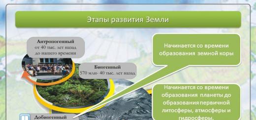
It is not enough just to know what a globe is. You need to learn how to read it correctly in order to learn a lot of new and interesting things. In this lesson we will learn what the colors on the globe mean. Let's learn the names of the oceans and continents, talk about their features and differences. Let's get acquainted with the amazing wonders of nature, flora and fauna.
Why blue and blue color the most on the globe? Most of earth's surface covered with water. In a photograph taken from space, all areas of water appear blue. This color on the globe indicates oceans and seas, rivers and lakes.

Rice. 2. Earth from space ()
But if you look closely, you will notice that in different places the ocean is indicated by different shades. This is done to show depth: the deeper the ocean, the darker Blue colour, and the shallower the depth, the lighter the paint on the globe. - these are huge expanses of bitterly salty water that surround continents and islands.

Pacific Ocean - the largest on Earth.

Rice. 4. Physical card Pacific Ocean ()
This name was given to him by the navigator Ferdinand Magellan, because during his journey to sailing ships this ocean was calm. Although in fact the Pacific Ocean is not quiet at all, especially in its western part, where it raises and drives huge waves - tsunami, bringing a lot of trouble to the inhabitants of the Japanese islands.

Mariana Trench- the deepest place in the world. It is located in the Pacific Ocean, its depth is eleven kilometers and thirty-four meters.

Rice. 6. Mariana Trench ()
Previously, Europeans did not even suspect the existence of the Pacific Ocean. They knew only one ocean - Atlantic, which seemed limitless, so it was named after the most powerful hero of Greek myths, Atlas.

Rice. 7. Physical map of the Atlantic Ocean ()
In fact, the Atlantic Ocean is the second largest after the Pacific Ocean, the greatest depth of the ocean is 5 kilometers. IN Atlantic Ocean There are huge waves as high as a three-story building.
Indian Ocean It is especially restless in its southern part. It is warmer than others, even in the northern part of the water Indian Ocean warm up to + 35 degrees.

Rice. 8. Physical map of the Indian Ocean ()
Arctic- the northernmost region, covered in winter and summer with a thick layer of ice and snow. U North Pole there is a fourth ocean, almost its entire surface is covered with thick strong ice, and there are multi-meter snowdrifts around. That's why this ocean was named Arctic.

Rice. 9. Physical map of the Arctic Ocean
Relatively recently, oceanographers began to identify a fifth, South ocean.

Rice. 10. Physical map of Antarctica ()
Previously, this ocean was considered to be the southern parts of the Indian, Atlantic and Pacific oceans. All oceans together: Pacific, Indian, Atlantic, Arctic and Southern - merge together into one world Ocean, which washes the entire globe.
On the globe, large areas of land called continents are depicted in green, yellow, brown and white. On the ground six continents: Eurasia, Africa, Australia, Antarctica, North America, South America.
Eurasia- the largest continent, within its borders lie two parts of the world: Europe and Asia.

Rice. 11. Physical map of Eurasia ()
It is the only continent on Earth washed by four oceans: the Arctic in the north, the Indian in the south, the Atlantic in the west and the Pacific in the east. Our homeland is located on this continent Russia.

Rice. 12. Russia on the map of Eurasia ()
The surface of the continent is very diverse. Mountains and plains are the main forms of the earth's surface. Brown color indicates the location of the mountains, and green and yellow indicate the location of the plains. The largest of them West Siberian (flat plain), Eastern European(hilly plain).

Rice. 13. West Siberian Plain ()

Rice. 14. Physical map of the East European Plain ()
Rivers are indicated on the globe by uneven blue lines drawn along the surface of the continents. Rivers flow across the East European Plain Volga, Don, Dnieper, By West Siberian a river flows across the plain Ob. Mountains rise above the surface of the plains. The higher the mountains, the darker their color on the globe. Himalayas are the highest mountains in the world.

Rice. 15. Himalaya mountains ()
Jamalungma (Everest)- the highest mountain in the world (8 km 708 m).

Rice. 16. Mount Jamalungma ()
Located in Eurasia Baikal- the deepest lake,

Rice. 17. Lake Baikal ()
The largest lake

Rice. 18. Caspian Sea ()
largest peninsula Arabian,

Rice. 19. Coast of the Arabian Peninsula ()
lowest point of land in the world - depression Dead Sea.

Rice. 20. Dead Sea ()

Rice. 21. Pole of Cold Oymyakon ()
Africa is the second largest continent, which is located on both sides of the equator, washed by the Atlantic Ocean from the west and the Indian Ocean from the east and south.

Rice. 22. Physical map of Africa ()
Africa is known for its diversity of nature: impenetrable tropical forests with orchids,

Rice. 23. Rainforest ()
grassy plains with baobabs (huge trees up to forty meters in circumference),

vast expanses of desert.

Rice. 25. Desert in Africa ()
Africa is the hottest continent on the planet. Here it is Sahara Desert.

Rice. 26. Sahara Desert ()
It is the largest desert in the world and the hottest place on Earth (the maximum recorded temperature is +58 degrees). On this continent flows Nile- the second longest river in the world.

Rice. 27. River Nile ()
Volcano Kilimanjaro- the highest point in Africa.

Rice. 28. Mount Kilimanjaro ()
Victoria, Tanganyika, Chad- the largest lakes on this continent.

Rice. 29. Lake Victoria ()

Rice. 30. Lake Tanganyika ()

Rice. 31. Lake Chad ()
In the Western Hemisphere are North America And South America, they are washed from the west by the Pacific Ocean, from the east by the Atlantic, and North America is also washed by the Arctic Ocean from the north.

Rice. 32. Physical map of North America

Rice. 33. Physical map of South America
North America also includes the largest island on Earth, it is called Greenland.

Rice. 34. Coast of Greenland ()
These continents are rich in rivers and lakes. North America is home to one of the world's greatest rivers Mississippi,

Rice. 35. Mississippi River ()
and in South America there is a river that is the largest in the world in terms of depth and length.

Rice. 36. Amazon ()
There is a bay on the coast of North America Fundy, which, in addition to its incredible beauty, is famous for the largest tides in the world, more than seventeen meters.

Rice. 37. Bay of Fundy ()
Just imagine, millions of tons of water approach the shore in twelve hours and then move away from it. South America is home to the world's tallest waterfall - Angel, its total height is 979 meters.

Rice. 38. Angel Falls ()
It seems as if it is shrouded in fog - a curtain of tiny particles of water that is sprayed, falling from such a great height. The most powerful waterfall in the world is located on the same continent Iguazu.

Rice. 39. Iguazu Falls ()
Although in fact it is a whole complex of 270 individual waterfalls, which is about 2.7 km wide. South America is home to the driest place in the world - the desert. Atacama.

Rice. 40. Atacama Desert ()
In some places in this desert, rain falls once every few decades.
Australia- the fifth continent, which is smaller than all the others. The Pacific Ocean washes the northern and eastern coasts, the Indian Ocean washes the western and southern coasts.

Rice. 41. Physical map of Australia
Most of the continent is occupied by deserts and semi-deserts, there are very few rivers, which is why Australia is considered the driest continent on Earth. Common here screams(English creek - rivulet) - rivers that exist only during the rainy season and completely dry up for most of the year.
A geographic map of the world is an overview map of the relief of the earth's surface. The geographical map of the world has a coordinate grid. This geographic map of the world does not display individual states and countries to generalize and simplify the display of surface relief above sea level (the darker the color, the higher the surface). A geographic map of the world clearly and concisely shows information about the main continents, seas and oceans and allows you to quickly create an image of the relief of the whole world.
Geographic map of the world in Russian:

Geographic map of the world showing all continents. Smaller view of a geographical map of the world:

Geography lessons at school often require contour map world:

Geographic map of the world with continents:

2008 — 2018 © Maps-of-World.ru — detailed maps countries of the world in Russian with cities.
Continents and oceans alternate on the surface of the Earth. They differ in geographical location, size and shape, which affects the characteristics of their nature.
Geographical location and size of continents
Continents are distributed unevenly on the Earth's surface.
In the Northern Hemisphere they occupy 39% of the surface, and in the Southern Hemisphere they occupy only 19%. For this reason North hemisphere The lands are called continental, and the southern one is called oceanic.
Based on their position relative to the equator, continents are divided into a group of southern and a group of northern continents.
Since the continents are located in different latitudes, they receive unequal amounts of light and heat coming from the Sun.
In shaping the nature of a continent, its area plays an important role: the larger the continent, the more areas it contains that are remote from the oceans and not affected by them.
Oceans of the world: map, names, description, area, depth, plants and animals
Has great geographical significance mutual arrangement continents.
Continents
Continents and parts of the world
Formation of oceans and continents
Origin of continents and oceans

Geographical location and size of the oceans
The oceans that separate the continents differ from each other in size, water properties, current systems, and features of the organic world.
The Pacific and Atlantic oceans are similar geographical position: They stretch from the Arctic Circle to Antarctica.
The Indian Ocean lies almost entirely in the Southern Hemisphere. The Arctic Ocean has a special geographical location - it is located around the North Pole within the Arctic Circle, covered sea ice and is isolated from other oceans.
The border between continents and oceans runs along the coastline. It can be straight or rugged, that is, having many protrusions.
In the rugged coastlines many seas and bays. Protruding deep into the land, they have a significant impact on the nature of the continents.
Interaction of continents and oceans
The land and waters of the World Ocean have different properties, but they are constantly in close interaction.
The oceans greatly influence the natural processes on the continents, but the continents also take part in shaping the characteristics of the nature of the oceans.
Continents and oceans on the surface of the Earth Wikipedia
Site search:
Continents of the Earth and parts of the world: names and descriptions
Planet Earth

Scientists believe that the Earth has existed for 4.5 billion years. At the same time, life began to emerge on it approximately 4.2 billion years ago. Formation of the Earth's ozone layer and its magnetic field helped protect and preserve developing life on the planet to this day.
Our planet is located third (after Mercury and Venus) from the Sun, which helps it preserve the necessary conditions for life on the planet.
The distance from the Earth to the Sun is about 150 million kilometers, or this distance is also called 1 astronomical unit. The air temperature on the planet in the coldest place reaches – 85 degrees Celsius in Antarctica and + 70 degrees Celsius in the hottest part of the planet – the Sahara Desert.

Planet Earth rotates around its own axis and makes one revolution around its axis in 24 Earth hours, which are called days.
In one day we have time to see the sunrise, its gradual approach to the horizon, the sunset and the absence of the Sun in the sky, which is again replaced by the sunrise on the horizon. The Earth also revolves around the Sun, and it makes one revolution around the Sun in 365 days or 1 calendar year, as is commonly believed. Over the course of 1 year, the seasons on the planet change on the continents, and changes occur differently in different parts of the planet.
The only one natural companion Throughout its entire history, the Earth has had and remains the Moon.
The Moon always faces the Earth with one side, and the other always looks into space. Today, more than 8,000 revolve around the Earth. artificial satellites that people sent into space.

In its shape, planet Earth is similar to an oblate ellipsoid.
The planet's diameter is 12,742 km and its circumference is 40,000 km. Given its size, the Earth's surface is covered by 70.8% water and only about 29.2% of the planet's surface is land. The highest point of land on our planet is Mount Everest (8,848 km above sea level). And the deepest point on our planet goes 10.994 km below sea level and is called the Mariana Trench.
Geographic map of the world
Oceans and continents of planet Earth
On planet Earth, at one time there were 6 continents (Eurasia, Africa, North America, South America, Australia and Antarctica) and 6 parts of the world (Australia, Asia, America, Antarctica, Africa and Europe), which differ in their borders from each other . All continents and parts of the world are washed by 5 oceans of the planet: the Pacific Ocean, the Indian Ocean, the Atlantic Ocean and the Arctic Ocean.

The structure of planet Earth
In the center of the planet there is a core whose size reaches 7000 km in width.
The average radius of the core is 3500 km, of which inner part The core is solid (1300 km), consists mainly of metal and nickel, and the outer part of the core (2200 km) is liquid. It is the movement of the outer part of the core that forms the Earth's magnetic field, which protects all living things from cosmic radiation.

The core is followed by the mantle (which goes 2800 km deep into the Earth) - it is partially in a liquid state. Scientists have divided the mantle into the Lower and Upper Mantle.
The lower mantle reaches a depth of up to 600 km from the surface of the planet. And the Lower Mantle ends at a depth of 2800 km from the Earth’s surface.
And above the mantle is the earth's crust, which we know as upper layer land.
Its thickness reaches from 10 to 70 km. Earth's crust consists of huge plates that can move and collide with each other, resulting in the formation of mountains and powerful earthquakes.
The atmosphere of planet Earth consists of 77% nitrogen, 22% oxygen and 1% gases. This ratio of substances in the atmosphere turned out to be ideal for all living creatures that live on the planet and plants.
Today the planet is inhabited by millions different forms lives (animals, plants, birds, insects, fish, etc.), including people, whose number in 2011 exceeded the threshold of 7 billion people and continues to grow. Our planet is rich in beautiful and amazing places, which fascinate with their beauty and mystery.
And also has its own records!

Over the years of its existence, humanity has made great progress in terms of technology development, but has caused enormous damage to the planet itself.
I would like to believe that soon people will begin to correct their mistakes and save the planet from their harmful effects. Otherwise, no one will survive on this beautiful planet.

Report-message on the surrounding world for grades 2-3 on the topic “Continents”
 The world's oceans occupy a large area of the Earth.
Land occupies only twenty-nine percent of the surface.
A continent is a large land mass that is surrounded by water.
Today there are 6 continents:
- Eurasia
- North America
- South America
- Africa
- Australia
- Antarctica
Eurasia
Eurasia is the largest continent on Earth.
It occupies more than one third of the land area. The population of this continent is more than five billion people, which is equal to seventy percent of the total population of the Earth. The extreme point in the west is Cape Roka, in the east is Cape Dezhnev. Eurasia is the only continent on the planet washed by four oceans: the Pacific, Atlantic, Indian and Arctic.
The surface of Eurasia is very diverse. The mainland contains the largest plains and mountain systems peace. This continent is the highest continent on the planet. The average height is approximately eight hundred and thirty meters. Eurasia is home to the highest altitude mountains on the planet – the Himalayas.
Africa
The second largest continent by area is Africa.
Its area makes up one fifth of the planet's land mass. On South extreme point is Cape Agulhas, in the north is Cape El Abyad. They are equidistant from the equator. With the exception of the Isthmus of Suez, which is a small strip of land, this continent is almost entirely surrounded by water. The continent is washed by the Indian and Atlantic Oceans and the Mediterranean Sea.
Continents and oceans on the surface of the Earth
The continent's population is located primarily in isolated areas. Most people live on the west coast, in the Nile Valley and around Lake Victoria.
Australia
The smallest continent on the planet is Australia.
This continent is entirely in the southern hemisphere. Australia is washed in the north, west and south by the Indian Ocean, in the east by the Pacific Ocean.
The continent is significantly removed from other continents. There are no land routes with them. Much of the continent is sparsely populated or uninhabited. Australia became a separate continent 65,000,000 years ago. Due to its isolated location, there are many species of flora and fauna not found in other countries.
Antarctica
Antarctica is the fifth largest continent in terms of area and is the coldest continent. This continent is located beyond the Antarctic Circle. Almost the entire area of the continent is covered with ice, the thickness of which is more than three kilometers.
The continent is washed by the Pacific, Atlantic and Indian oceans. There is practically no flora or fauna here.
America
South America ranks fourth in area. This continent makes up thirteen percent of the Earth's total landmass.
In the west it is washed by the Atlantic Ocean, in the north by the Caribbean Sea. Here is the longest chain of mountains on the planet - the Andes. Earthquakes often occur here.
North America lies entirely in the northern hemisphere. This continent ranks third in area. North America is washed by the Pacific, Atlantic and Arctic oceans.
Eurasia and North America are separated by the Bering Strait.
Download the report “Continents”
site menu
The meaning of many modern words was formed a long time ago, sometimes in classical ancient times.
And sometimes it is interesting to find out how the meaning of words has changed or how it was originally formed
their meaning.
This section contains some interesting modern words and concepts whose origin
originates many centuries ago, or, on the contrary, they were formed quite recently.
The selection does not pretend to be unique or academic.
It's simple Interesting Facts and stories...
America. Since 1402 Columbus made four voyages to the shores of America, discovered many islands, and in 1498 entered the mainland.
Oceans and continents, their names, locations
It became clear that new lands unknown to Europeans had been discovered. However, the idea of their existence was first expressed by Amerigo Vespucci, who took part in two expeditions (1499-1504) to open lands. An inquisitive and observant person, he compiled the first description of new lands, his letters about travel received great fame in Europe, and open New World was named after him.
Australia is a continent located in the southern hemisphere, from the Latin “southern”.
Antarctica is a continent located in the southern hemisphere, beyond the Antarctic Circle.
The name of the continent comes from the Greek word “anti” - against, i.e. the region lying opposite the northern polar region of the globe - the Arctic.
The Arctic is the northern polar region of the globe, including the Arctic Ocean with its seas and islands, adjacent parts of the Atlantic and Pacific oceans, as well as the outskirts of the continents of Eurasia and North America.
The name comes from the Greek “arktos” - “bear”; country under the constellation Ursa Major in the Far North.
Africa is the second largest continent on the planet. The origin of its name is interpreted differently:
1) lat. africus - “frost-free, not knowing the cold”;
2) this is what the Romans called a small tribe that lived south of Tunisia, and its location was “Africa”.
Europe is part of the world.
The word is so ancient that it is extremely difficult to trace its origins. The name could come from the Semitic “ereb” or “irib”, which means “west” or from the Phoenician “Erep” - sunset; sunset. Another version: in Ancient Greece the word “Erebos” meant darkness, darkness, the underground kingdom of the dead. Europe is a part of the world, the western part of the Eurasian continent. According to legend, the Greek father gods Zeus, kidnapped the beautiful Europa from Phenicia, took her to Crete and conceived several children with her here.
Aral Sea - from the Turkic Aral, which means “island”.
This is what the area at the mouth of the Amu Darya was first called.
The Sea of Azov - in Arabic Bar el-Azov - “dark blue sea”.
Antilles from the Greek word “anti” - “against”, “ahead”, “against the mainland”.
The Azores are ten large and several small, mostly uninhabited islands. The thick shroud of fog that now and then envelops the Azores has become a kind of symbol of the archipelago; another, less well-known name, which sounds like “Ilhas de Bruma” (foggy islands).
Alaska is a peninsula in the northwest of North America.
From Aleutian alaskhas, means “big land”.
Bay of Bengal - from the Hindu word bangala, which means “home of banga”; (Bangays are ancient inhabitants of the coast).
Bosphorus Strait (Greek) - “cow ford”. By Greek mythology, the beautiful Io, transformed by Zeus's wife, the goddess Hera, into a cow, pursued by a gadfly, fled from Greece and swam across the Bosporus.
The Bab el-Mandeb Strait connects the Red Sea and the Gulf of Aden - the “gate of tears.”
Greenland is an island, “green country” (in Danish), discovered in the 19th century by the Norman Vikings.
Hudson Bay is named after the English navigator Hudson, who discovered the bay in 1610.
California is a peninsula on the west coast of North America.
It means “hot forge”, because In summer the air temperature here is very high.
The Caspian lake-sea is part of a formerly vast sea. The name of the sea is associated with the name of the person who lived on its shores in the first millennium BC. of the Caspian people.
Red Sea - According to one version, the name of the sea depends on the part of the world. In the mythical tales of many peoples of the world, the cardinal directions are associated with certain color shades. For example, red color symbolizes the south, white - the east, black (among a number of Asian peoples) - the north.
Hence the name “Black Sea” does not mean “sea with dark, black water,” but “sea located in the north.” After all, the Turks called this sea Kara-Deniz, the ancient tribes who spoke Iranian languages called it Akhshaena (dark), and the Scythians called it Tama, which is also associated with the meaning “dark.”
As for the Red Sea, the word “red” seems to indicate its southern location, and not at all the color of the sea water.
Madeira - an island in Portugal - “wine island”. In XYv. The famous Portuguese traveler Henry the Navigator planted shoots of Malvasian grapes brought from Crete in Madeira. So the grapes went into exile in Madeira.
Gulf of Mexico - its name is associated with the state of Mexico, which in turn is named after the Aztec god of war - Mehitli.
Newfoundland - from English.
- “newly discovered land.” In 1003 The Viking ships Torfini Karlefni sailed further south from Labrador. Two days later, a new land opened up before the travelers.
The rugged coastline was covered with coniferous forest. Thorfinn named this land Markland - “forest country”.
Florida Peninsula North. America - “blooming” (Spanish).
Aegean Sea (Greek) - “exciting”.
Yucatan Peninsula North.
America - in the language of the local Indians it means “we don’t understand you” (this is how the inhabitants of this peninsula answered the first Europeans who asked “what is the name of this land?”)
They alternate on the surface of the Earth. They differ in geographical location, size and shape, which affects the characteristics of their nature.
Geographical location and size of continents
Continents are distributed unevenly on the Earth's surface. In the Northern Hemisphere they occupy 39% of the surface, and in the Southern Hemisphere they occupy only 19%. For this reason, the Northern Hemisphere of the Earth is called continental, and the Southern Hemisphere is called oceanic.
Based on their position relative to the equator, continents are divided into a group of southern and a group of northern continents.
Since the continents are located at different latitudes, they receive unequal amounts of light and heat from the Sun. In shaping the nature of a continent, its area plays an important role: the larger the continent, the more areas it contains that are remote from the oceans and not affected by them. The relative position of the continents is of great geographical importance.
Geographical location and size of the oceans
The continents that separate them differ from each other in size, water properties, current systems, and features of the organic world.
And they have a similar geographical location: they stretch from the Arctic Circle to. almost entirely in the Southern Hemisphere. It has a special geographical location - it is located around the Arctic Circle, covered with sea ice and isolated from other oceans.
The border between continents and oceans runs along the coastline. It can be straight or rugged, that is, having many protrusions. The rugged coastlines have many seas and bays. Protruding deep into the land, they have a significant impact on the nature of the continents.
Interaction of continents and oceans
Land and water have different properties, but they are constantly in close interaction. The oceans greatly influence the natural processes on the continents, but the continents also take part in shaping the characteristics of the nature of the oceans.
Our home planet Earth consists of continents that are washed by oceans. Scientists believe that our planet formed 4.5 billion years ago, and life 600 million years after the formation of the planet. Since then it has been constantly changing.
The entire surface of our planet consists of water and land. Water takes up more 2/3 surface of the Earth, and the solid part accounts for only 29% . The land consists of continents and islands. The water part of the surface is divided into oceans, seas, lakes and rivers.
How many continents are there on Earth and what are they called?
A continent is a part of the solid surface of our planet, which is washed on all sides by water. Sometimes these parts of the Earth are called continents. The continents are distributed fairly evenly. There are six of them in total. They are called Eurasia, Africa, North America, South America, Australia and Antarctica.
IMPORTANT: Not long ago, scientists doubted that there were only six continents. Recent studies show that their number may today be replenished by another continent.
EURASIA. The largest continent on Earth is Eurasia. Its area occupies 36% the entire solid surface and is about 55 million square kilometers. Ural Mountains divide the continent into two parts of the world: Europe and Asia. Russia occupies the largest part of Eurasia.
The continent was originally called Asia. This term was introduced into use by a German encyclopedist. Alexander Humboldt V late XVIII century. The term appeared in scientific literature in the 1880s at the suggestion of an Austrian geologist Eduard Suess.
The continent was formed after the split of the protocontinent Laurasia into two parts: North America and Eurasia.
Eurasia a few facts:
- Tibet is the highest point in the world
- The Dead Sea Trench is the lowest point in the world
- Oymyakon is the coldest point in the world
- Bosphorus is the most narrow strait in the world
- Eurasia is the birthplace of major civilizations
- All climate zones are located in Eurasia
- Population of Eurasia – 4.5 billion Human ( 75% population of our planet)
AFRICA. The second largest continent on Earth is Africa. The area of this continent is 30 million square kilometers ( 6% sushi). Most scientists agree that Africa is the cradle of our civilization.
Term "afri" introduced by the inhabitants of ancient Carthage. They called them people who lived near their city. Most likely the term comes from the Phoenician word "afar" — dust. The Romans, who defeated Carthage, named their new province Africa. After which the nearby lands, and subsequently the entire continent, began to be called Africa.
INTERESTING: Some scientists believe that the name Africa could come from the Latin word "aprica" (solar). Historian African Lion believed that the term could be formed from the Greek word «φρίκη» (cold). Letter «α-» added at the beginning of this term translates as "without" — « no cold" Russian science fiction writer and paleontologist Ivan Efremov believed that the word came from an ancient language Ta-Kem(Old Egypt. "Afros" - foam country).

The future continent of Africa occupied a supercontinent Gondwana central place. When the plates of this continent diverged, Africa acquired its modern shape.
The most unique place in Africa is undoubtedly the desert. Sahara. In area it occupies 9 million square kilometers (larger than the United States) and covers ten countries. At the same time, the desert area is growing every year. Most of the desert is not sand, but stones and pebbles.
The Sahara is the hottest desert in the world (its surface can warm up to 80 degrees), but underneath there is a huge underground lake ( 375 square kilometers). Thanks to which you can find oases in the Sahara.
Africa a few facts:
- There are places in Africa where no human has ever set foot before.
- On this continent there are tribes with the tallest and shortest inhabitants of the Earth
- Healthcare in African countries is at its lowest level. Because of this, the average life expectancy on this continent 48-50 years
- In Africa they speak 2000 languages. The most popular of them is Arabic
- This continent has large reserves of gold and diamonds. Half of all gold is mined in Africa
- Before 80% Africa's GDP comes from agriculture. The most popular crops grown are cocoa, coffee, dates, peanuts and rubber trees
NORTH AMERICA . North America is located in the northern part of the Western Hemisphere. The area of this continent is 20 million kilometers2. Moreover, almost the entire territory of the mainland is divided between Canada and the United States. Although the continent consists of territories 24 countries The continent was discovered in 1502 year.
It is believed that America was discovered by an Italian explorer Amerigo Vespucci. The continent was named after him. German cartographers proposed to do this Martin Waldseemuller And Mathias Ringman. The first world map in which this continent was designated as America appeared in 1507 year.

 North America
 INTERESTING: There is evidence that Vespucci was not the discoverer of this continent. They did it long before him Scandinavian Vikings led by their legendary leader Eric the Red. IN 986 year they reached the shores of America. But it is believed that the Vikings knew in advance where to sail. This means that they learned about the new lands from someone else.
Like all other continents, North America was formed after the breakup of supercontinent plates. Initially, parts of the plates that form modern North America were part of a supercontinent Pengea. Then it broke away from him Laurasia and from this protocontinent North America and Eurasia were formed.
North America a few facts:
- This continent includes the largest island on our planet - Greenland
- Hawaiian mountain Mauna Ke and is considered the highest in the world. Its height is 2000 meters higher than Chomolungma
- The largest administrative building in the world is considered Pentagon
- The world's largest popcorn factory operates in the US state of Iowa.
- The average continental resident spends 90% of your free time indoors
SOUTH AMERICA . A continent that is predominantly located in Western and Southern Hemispheres of our planet. The mainland occupies about 18 million square kilometers. It is inhabited by over 400 million Human.
During the Cretaceous period, the supercontinent split Pangea. I broke away from him Gondwana. This proto-continent then broke up into Africa, Australia, Antarctica And South America.
Part of South America discovered Columbus. It was he who was the first European to suggest the existence of a large continent.
 South America
 South America a few facts:
- The largest country in South America is Brazil
- The largest river in the world flows through this continent - Amazon
- South America has the largest waterfall in the world - Angel
- Capital city of Bolivia La Paz considered the highest capital in the world
- IN Chile The Atacama Desert is located where there is never any precipitation.
- IN Paraguay duels are still allowed
- South America is home to the largest beetles in the world - woodcutter beetles, the largest butterflies - agrippinas, the smallest monkeys - marmosets and the most poisonous frogs - the red-backed poison frog
AUSTRALIA. A continent located in the Eastern and Southern hemispheres of our planet. Its entire territory is occupied by one country. Which has the same name - Australia.
The mainland was discovered by Dutch sailors in the 17th century. V. Janszon in 1606 discovered the presence of new land in coral sea. It was a peninsula that was later called Cape York. The navigators determined that this piece of land is only a small part of it. And they named her Unknown Southern Land (Terra Australis Incognita). When legendary James Cook completely explored these lands; their name was shortened to "Australia".
The area of this continent is 8 million kilometers. Or 5% of the total land area. A third of the continent's territory is desert.


Australia a few facts:
- The continent has a very low population density. Because of this, it is not indicated by the number of people per square kilometer, as in other continents, but by the number of square kilometers per person
- Australia has built the most long road in the world. It is 145 km long and runs through the Nullarbor Desert.
- The Dingo fence is the longest fence in the world. Its length (5400 km) is twice as long as the Great Wall of China
ANTARCTICA. Name "Antarctica" derived from the word «ἀνταρκτική» (Greek opposite the Arctic). The term first appeared in the book Aristotle "Meteorology". The mainland was discovered by Russian navigators F. F. Bellingshausen And M. P. Lazarev V 1820 year. In 1890 the continent was given official name"Antarctica". This was done by a Scottish cartographer John Bartholomew.
Antarctica a few facts:
- The continent, according to the 1959 Antarctic Convention, does not belong to any of the countries. Only scientific activities are allowed here
- Scientists have found traces of tropical life in the continent's glaciers. Remains of palm trees, araucarias, macadamia, baobab and other heat-loving plants
- Over 35 thousand tourists visit Antarctica every year. They observe colonies of seals, whales and penguins, go scuba diving and visit science centers
- There are two major marathons on this continent: the Antarctic Ice Marathon and the McMurdo Marathon.
SEVENTH CONTINENT . Periodically, funds mass media inform that scientists have “discovered” a new, seventh continent. Most often this education includes New Zealand, Caledonia and nearby islands. They are located on the same plate, which was once part of the supercontinent Gondwana. The plate area is 4.9 million square kilometers, and it fully suits the requirements of the continent.
How many parts of the world are there on Earth and what are they called?
Parts of the world are established historical and cultural formations, which, along with continents, include islands and other parts of land. At the same time, one part of the world can include two continents - America. But one continent can also include two parts of the world. On the continent of Eurasia there are such parts of the world as Europe and Asia.
Today it is customary to distinguish six parts of the world:
- Europe
- America
- Antarctica
- Australia and Oceania
But, in addition to this conventional division, our planet is divided into "New World" And "Old light". The “Old World” includes Europe, Asia and Africa. That is, those parts of the world that were known to the ancient Greeks. During the period of the Great geographical discoveries, America, Australia and other parts of the land appeared on the world map. Which were discovered after 1500. They are classified as the “New World”.
How many continents are there on Earth and what are they called?
Very often, people get confused when mentioning the words continent and continent. Is there a difference between these concepts? Today these terms are considered synonymous. Both continents and continents are huge land masses that are washed by water on all sides. Therefore, it is customary to distinguish six continents. The same ones that we talked about in the first section of this article. Namely:
- North America
- South America
- Antarctica
INTERESTING: The above model is used by Russian geographers. In India, China, Western Europe and some English-speaking countries there are seven continents. They classify Europe and Asia as different continents. In Spanish-speaking countries, Greece and Eastern European countries, North and South America are united into a single continent. Additionally, some scientists use a model of the earth consisting of four continents: Afro-Eurasia, America, Antarctica and Australia.


How many oceans are there on planet Earth and what are they called?
The oceans are the largest water bodies on our planet. They wash the continents and make up about 2/3 surface of the planet ( 360 million square kilometers). As in the case of continents, there are several options for dividing the World Ocean.
- The ancient Romans called the word "oceanus" all the “big” waters that washed the territory known to them. At the same time, they highlighted:
- Oceanus Germanicus or Oceanus Septentrionalis- North Sea
- Oceanus Britannicus- strait of the English Channel
Today, scientists divide the world's oceans into four parts:
QUIET. The largest and deepest ocean. We occupy about 50% the entire surface of our planet. Name "Quiet" gave to the ocean Ferdinand Magellan. He crossed it in four months without encountering any obstacles.

Pacific Ocean a few facts:
- The deepest point on the earth's surface is Challenger Deep
- The largest landform is located in the Pacific Ocean - Great Barrier Reef
- Thor Heyerdahl crossed the Pacific Ocean on a primitive raft, proving the possibility of ancient people traveling over long distances
- More than half of all aquatic biomass is located in the Pacific Ocean
- In the northern part of the ocean there is a “large garbage patch”. This accumulation of human waste products covers an area of 700 thousand up to 115 million km²
ATLANTIC . The second largest area is the Atlantic Ocean. From 92 million square kilometers of its surface more than 16% falls on the seas, bays and straits. For the first time this ocean was called the Atlantic Herodotus. The Greeks believed that Mediterranean Sea, which belongs to this ocean, Atlas stood and held the sky on his shoulders.
Atlantic Ocean a few facts:
- In the center Belize Atoll there is a huge underwater hole. This picturesque place seems bottomless. But in fact its depth 120 meters
- The ocean passes through all the climatic zones of our planet
- The Atlantic Ocean is the area with the most difficult navigation. They call her « Bermuda Triangle» . Thanks to adventure literature and cinema, she was endowed with mythical power
- Through this ocean passes Gulf Stream– a warm current that warms European countries
INDIAN. Occupies a fifth of the World Ocean. The ancient Greeks called the western part of the Indian Ocean Eritrean Sea. But later this part of the World Ocean began to be called the Indian Sea. The final name for the Indian Ocean Oceanus Indicus gave Pliny the Elder in the 1st century AD.


Indian Ocean interesting facts:
- This ocean is considered the first officially discovered
- This ocean is believed to have the lowest fish catch
- The island states of the Maldives, Seychelles and Sri Lanka, washed by the waters of this ocean, are considered by many to be an ideal holiday destination.
- Considered the warmest ocean on our planet
ARCTIC . The smallest and shallowest ocean on Earth. Its area does not reach 14 million square kilometers. Was separated into a separate ocean in 1650 year geographer Varenius and named Hyperborean(ancient Greek Βορέας - mythical god of the north wind). In most countries it is called Arctic.
Arctic Ocean interesting facts:
- All ocean resources are divided between Russia, the USA, Canada, Denmark and Norway
- More than 25% of oil reserves are located in the waters of this ocean
- The main feature of this ocean are icebergs
INTERESTING: In some literature you can find the name of another one - the fifth ocean. He is called Southern and are located around Antarctica. But neither experts nor navigators consider part of the waters of the Atlantic, Pacific and Indian Oceans to be a real ocean. Last attempt to enter geographic Maps the world's Southern Ocean fell into 20 00 year. The International Hydrographic Organization has not ratified the decree separating this part of the World Ocean into an independent entity.
Map of continents and oceans on planet Earth


Video. Traveling around the planet, continents and oceans