Geography teacher Beznogova O.N. Municipal educational institution "Privalenskaya secondary school" of the Omsk region exit Geological chronology Geological chronology Geochronological table Geochronological table Geological map Geological map resources

Geological chronology (geochronology) Relative age Relative age Relative age Relative age Absolute age Absolute age Absolute age Absolute age Determined by the occurrence of rocks not disturbed in a later period and fossil remains - fossils. Determined by the ratio of the content of a radioactive element in a rock and its decay products. Other sciences that study the earth's crust Other sciences that study the earth's crust Other sciences that study the earth's crust Other sciences that study the earth's crust exit back The rocks that make up the earth's crust were formed at different times. The branch of geology that studies the age, duration, and sequence of formation of rocks.

Historical geology Geotectonics Paleontology Mineralogy Petrography What does it study? Studies the patterns of the structure of the earth's crust over geological time. The study of the structure of the earth's crust and the formation of tectonic structures. The science of extinct organisms studied from fossils, preserved hard skeletons, etc. The science that studies minerals. The science that studies rocks. Geochronology - studies the age, duration, sequence of formation of rocks. Branches Geology, studies the structure and history of the development of the Earth. exit back

Geochronological table Era, group The entire geological history of the Earth is divided into eras - large periods of time in the history of the Earth. (AR, PR, Pz, Mz, Kz). The entire geological history of the Earth is divided into eras - large periods of time in the history of the Earth. (AR, PR, Pz, Mz, Kz). The period, the Era system is divided into periods (see the tip for how easier it is to remember them). Hint K Every O Excellent St Student D Must K Smoke P Cigarettes T You Yu Yura M Mal P Wait N A Little Four Years K Every O Excellent St Student D Must K Smoke P Cigarettes T You Yu Yura M Mal P Wait N A Little H Four Years Contains information about the successive change of eras and periods in the development of the Earth and their duration. Contains information about the successive change of eras and periods in the development of the Earth and their duration. Museum (Internet) exit back table

Geological map Conventional signs A geological map allows you to get an idea of the distribution of rocks of different ages and origins. The territory of the southern part of the Omsk region is composed of sedimentary rocks of Neogene age. Example exit back

Slide 2 – drawing from the CD “Geography. Planet Earth" for 6th grade. OJSC Publishing House Prosveshcheniye Screenshots of the maps were taken from the disk maps K and M hammer jpg outcrop 7dbf40b95f96/004.swfhttp://files.school-collection.edu.ru/dlrstore/aa16a505-4efc-4dad-ab71-7dbf40b95f96/004. swf tectonic map exhibits of the museum of paleontology exit back

““Inland Waters of Russia” 8th grade” - Terek. Amur. Dnieper. Pechora. Don. Neva. Volga. Northern Dvina. Caspian lake. Angara. Aldan. Vasyugan swamp. Ladoga lake. Lake Imandra. Inland waters of Russia. Kuban. Lake Onega. Lake Peipus. Yenisei. Lena. Ob.
"Exploration of Antarctica" - Atlantis or Antarctica. Myth or real events. The land of a thousand lakes. The largest lake in Antarctica. Exploration of Antarctica. Atlantis. Endless coniferous forests. An island that has sunk into eternity. Volcanoes of Antarctica. Pennants. 16 years in distant Antarctica. Directions of scientific research. Antarctica was shifted towards the south pole. Methods of water purification. The glacier is creeping away. General information about Antarctica.
“Rivers of Ukraine” - Flows through the territory of Russia. Goryn. Dnieper in Kherson. Dnieper in Zaporozhye. Canals from the Dnieper. The bend of the Psel River. Black grouse. Problems of the Dnieper. River basin area. Dnieper in Dnepropetrovsk. Hydroelectric power stations on the Dnieper. Vorskla. Tributaries of the Dnieper. The source is in Russia. Mouth of the river. Case Rivers of Ukraine. The village of Bocharovo. Pripyat. Dnieper. The largest river basins in Ukraine. Photo from space. Ingulets. The beginning of the Dnieper.
“The position of Russia on the world map” - Borders of Russia. Geographical location of Russia. The longest borders. It is washed by the waters of 3 oceans. Place. Geographical position. Russia. Place of Russia. Length of borders. Gross domestic product. Russia on the world map. Extreme points of Russia.
“Islands of the Arctic” - The latter are represented by species of cladonia, the height of which does not exceed 3 - 4 cm. Saxifraga. Gaga. Now there are three settlements on Novaya Zemlya. Winter is stable; there are no thaws from November to April. Rhodiola rosea. The islands have an arctic climate. Animal world. White seagull. Island Arctic. Southern Capes. Arctic herbaceous annuals also play a significant role. About half the area of the North Island is occupied by glaciers.
“Soil Geography” - Supporting soil fertility. Mechanical composition of the soil. Soil fertility assessment. Impact of economic activities. Lesson objectives. Structural soil. Soil protection products. Erosion lands on the territory of Russia. New words for the lesson. The importance of rational use and soil protection. Soil protection from erosion. The main property of soils is fertility. Soil is the most important natural resource. Land reclamation in Russia.
"Verified"_________________
Short-term geography lesson plan 8.2.1.1.
Lesson No.Class8
date
Lesson topic:
Geological chronology
Target:
Study the features of geological chronology
Educational educational tasks:
To develop knowledge about the absolute and relative ages of rocks. Reveal the structure of the geochronological table. Develop skills and abilities to work with a geochronological table. Develop analytical thinking and the ability to express your own opinion.
Instilling values
Values based on the national idea “Mangilik El”:
Foster an active life position
Lesson type
Learning new material
Forms
Frontal, collective, group individual-isolated
Methods
Verbal, visual, reproductive
Modules
New approaches, RCM, ICT, ODO, ROiT, LU, VO
Equipment and
visual
benefits:
Physical map, tectonic map, geological map, geochronological table PC - presentation “Geological chronology”
Expected Result
All students will be able to name:
1. Stages of development of the Earth: planetary and geological.
2. Methods for determining the age of rocks.
3. Eras of Earth's development
Most students will be able to
Use a geochronological table.
Correlate eras-periods-duration
Some students will be able to
Talk about the patterns of geological processes, work with a geochronological table
Working with terms and concepts
Geology, tectonics, earth's crust, lithosphere, eras, periods, folding, plates and platforms, relief formation
Geographical objects:
Russian Platform, Turanian Plate, Gondwana, Laurasia
During the classes.
Lesson stepsPlanned activities
Resources
Lesson starts 7-10 minutes
Organizing time. Organization optimal conditions for educational activities. Checking student attendance.
Activation of cognitive activity
What is the name of the country we live in?
What continent is Kazakhstan on?
In what part of the Eurasian continent is Kazakhstan located?
Which countries does Kazakhstan border with?
What landforms predominate in Kazakhstan?
In what part of Kazakhstan are the mountains located?
Name the highest peak in Kazakhstan
Name the lowest point in Kazakhstan
What large plains do you know?
What mountain ranges are there in Kazakhstan?
Watch the video “history of the earth in 5 minutes”
Statement of the problem situation:
- Is the appearance of the earth’s surface of our country, its nature, random?
-Have they always been like this?
-If not, how and why did they change?
-How did scientists prove that nature was constantly changing and developing?
We have to answer these questions. Be careful.
Reception "Pass" - ball
PC - video
Mid-lesson 20-25 min
1. Introduction “People guessed that the nature of the Earth was not always the way people see it when they encountered fossils, plants and animals that no longer exist, and shells. Gradually, the science of ancient life—paleontology—was formed. What are the names of scientists involved in this science?
For many years, scientists around the world have been studying the preserved remains of animals and plants found in strictly defined layers of rocks. This means that the development of nature is inextricably linked with geological development, so they must be considered in unity. Currently, scientists have reconstructed a picture of the Earth's past by creating a geochronological table.
Determining the age of rocks allows us to establish the relative and absolute time that has passed since some moment or event in the history of the Earth. If the occurrence of rocks is not disturbed, then each layer is younger than the one on which it lies. The topmost layer was formed later than all those lying below. The time during which each group of rocks accumulated is called an era. Era name reflects relative time
– How is the absolute age of rocks determined?
Absolute age is the time elapsed since the rock was formed. It is determined by radioactive elements - for example, uranium. The rate of its decay is known and always remains unchanged (uranium decays into helium and lead, helium is seeded, lead remains) by the amount of lead the age of the rock is determined
Conclusion : Rocks are witnesses to the evolution of life
2. Working with a geochronological table pp. 34-35
Individual work turns into group work: students write down everything they know on this topic, or can extract from the table:
Which graphs stand out in it?
Read the names of the periods of each era from the oldest to the youngest.
What was the longest era in Earth's history?
Which periods were the longest?
Which period is the shortest?
What changes occurred in nature in each era?
What is the name of the era and period in which we live?
They exchange baskets, read and discuss.
3. Group work
1. group – Archean and Proterozoic era
Group 2 – Paleozoic era
Group 3 – Mesozoic era
Group 4 – Cenazoic era
Using atlas maps, a geochronological table and the textbook text, answer the questions and complete tasks on the contour map:
What periods does the era cover?
Duration of era
What type of mountain building took place?
What territories does the era cover?
Designate the areas where these rocks are found
What minerals are found
Defense of projects, discussion, distribution of points in the group: 1,2,3,4.
1. Pre-Paleozoic rocks (crystalline rocks: schists, gneisses - Tien-Shan village, Mugodzhary, Ulytau, Kokshetau).
2. Paleozoic sedimentary and igneous rocks (limestone, shale, sandstone - Tien-Shan village, Zhetysu Alatau, Tarbagatai, Altai; intrusions - copper, manganese, iron, tin, tungsten, gold).
3. Mesozoic rocks (Karatau, Pre-Uralsok plateau, Ileyskaya, Torgai depression).
4. Cenozoic rocks (throughout Kazakhstan):
A. Paleogene - basins: Shuiskaya, Ileyskaya, Zhaisan, plains - Ustirta, Aral region, Torgai plateau.
B. Neogene foothills of high mountain regions: sandy clays, loams.
B. Anthropogenic - everywhere.
Peer assessment - comment
Reception "Basket of Ideas"
Textbook
pp. 34 – 35
FO, mutual assessment
End of lesson 7-10 min
Individual work - test
Do a test job
1. How many eras are there in the development of our Earth?
A) 6; B) 5; AT 3; D) 4
2. How many periods are there in the development of the Earth?
A)12; B) 14; AT 6; D) 10
3.Which era in the history of the Earth was the longest?
A) Paleozoic; B) Proterozoic; B) Archean
4.The first organisms arose in:
A) soil; B) air; In water.
5. When did mammals appear on Earth?
A) Proterozoic; B) Paleozoic; B) Mesozoic.
6. The appearance of primitive birds is the time:
A) Proterozoic; B) Paleozoic; B) Kainaza.
7. In what era and period were the first deserts formed on Earth?
A) Paleozoic; B) Cenozoic; B) Mesozoic;
D) Devonian; D) Perm; E) Jurassic
8.When did the first man appear?
A) Cenozoic era; Quaternary period;
B) Paleozoic era; Permian period;
B) Cenozoic era; Paleogene period
9. The most ancient folding on earth was formed in:
A) Archean era; B) Proterozoic era;
B) Paleozoic era.
10.Which minerals were the first to form on Earth?
A) Oil; B) Iron ore; B) Coal.
Peer review
1-b, 2-a, 3-c, 4-c, 5-c, 6-b, 7-d, 8-a, 9-a, 10-b
Grading
13 – 14 – “5”
12 – 10 – “4”
9 – 7 – “3”
Reflection “Boats at Sea”
Differentiation - How do you plan to support students?
How do you plan to encourage bright students?
Assessment - How do you plan to check student learning?
Health and safety precautions.
Reflections
Were the lesson/learning objectives realistic? What did students learn today? What was the atmosphere in the class? Did the differentiation I made work? Was the training time maintained? What deviations were there from the lesson plan and why?
final grade
Which two aspects of the learning went very well (in terms of teaching and learning)?
What two things could improve the lesson (taking into account teaching and learning)?
What did you learn about students as a whole or individuals?
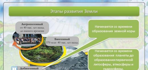
Geological history of the EarthThe Earth was formed about 4.5 billion years
back from the protoplanetary disk -
masses of gas and dust remaining from
formation of the Sun, which gave
the beginning of the solar system.
The geological stage of planet Earth began about 2.5 billion years ago with the formation of the earth's crust, oceans and continents, the gas shell
Geological stage of the planetEarth began around 2.5 billion
years ago since formation
earth's crust, oceans and
continents, gas
shells of the planet.
Distinguish between absolute and relative geological age
To establish the absolute age, the ratio of the content of isotopes of radioactive chemical elements (uranium, thorium, potassium) is used
To establishabsolute age
use the ratio
isotope content
radioactive chemicals
elements (uranium, thorium,
potassium, etc.) and their products
radioactive decay in
rocks
The age of geologically young rocks is calculated by the content of the radioactive carbon isotope C14 in the rocks - the so-called ra
Age of young people in geologicalmeaning breeds are calculated by
radioactive content in rocks
carbon isotope C14 –
so-called radiocarbon dating
analysis.
Due to the relatively short
half-life of C14
radiocarbon dating method is applicable
only for deposits, absolute
whose age does not exceed 60
thousand years
Absolute age shows the duration of existence of a geological formation in years (thousand years, million years, billion years)
To establish the relative age, stratigraphic (by studying the sequence of occurrence of layers) and paleontological
To establishrelative age
use
stratigraphic (by
study
sequences
occurrence of layers) and
paleontological methods
Undisturbed horizontal occurrence of layers of sedimentary rocks
It is believed thatthe youngest at
such a occurrence
there will be layer 3, the most
ancient – layer 1
(according to
geological
sequences
layer deposits) Thin, corrugated bedding in limestone from
masonry of the Roman aqueduct. Bedding rate
limestones in situ was equal to 1 mm/year. Above sample
a centimeter ruler is provided
The paleontological method is based on the study of fossil organisms and plants buried in rock strata
Fossil organisms and animals (lead species)
Leading fossils are representatives of flora or fauna characteristic of a certain geological period. They don't meet anywhere else
ancient, no moreyoung breeds.
The paleontological method is used to determine the age of rocks, mainly in combination with other methods (stratigraphic and radioisotope).
Paleontologicalthe method is used for
determining the age of rocks in
mainly in conjunction with
other methods
(stratigraphic and
radioisotope).
The age of rocks and geological processes is given in accordance with the geological time scale (geochronological scale). On geological
Age of rocks and geologicalprocesses is given in
according to the scale
geological time
(geochronological scale).
On geological documents
age is indicated
in Latin letters with
index numbers -
for example, PZ, D3 – C1, QIII, etc.
Geological history of the Mesozoic and Paleozoic eras
Geological history of the Cenozoic era
Quaternary (Q)
This is the shortest geological periodbut it was in him that it was formed
most modern landforms,
river valleys and a lot happened
significant events in the history of the Earth (from
point of view of modern history),
the most important of which are the ice ages
and the emergence of man. Last era
Quaternary period - Holocene (QIV) time of formation of floodplains and channels
modern rivers, soil formation.