We bring to your attention the 30 best photos from the views of the night side of the Earth, taken since May 1, 2003 from the ISS. Photos taken from album by Marshall Space Flight Center, NASA
(Total 30 photos)
1. Aurora over New Zealand, Tasman Sea. (NASA)
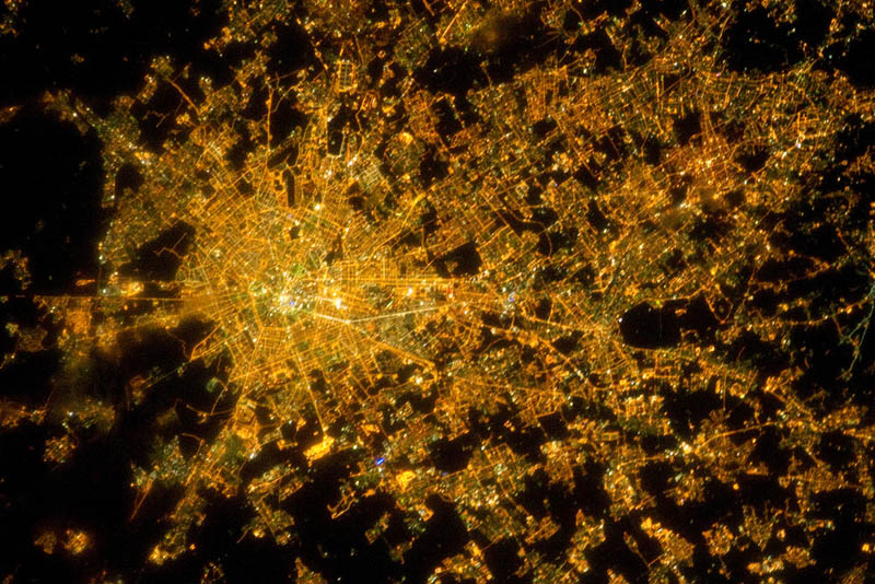
2. Milan, Italy, February 22, 2011. The lights of Milan are reminiscent of a checkered fabric pattern. Bright white lights - the historic center of the city, where the Milan Cathedral is located. The dark areas to the north are the fields that separate small towns. Due to low clouds, some areas look washed out. Milan is the largest city in Italy and the fifth largest in the European Union. It is one of Europe's transport, commercial and industrial centers and a worldwide center of fashion and culture. The Globalization and Exploration of the World's Cities Network categorized it as "alpha". (NASA)
3. Tokyo, January 9, 2011. The photo was taken from a height of 350 km above the Earth. Most of the territory in the photo belongs to Tokyo. On the left, just below the middle of the picture, is Yokohama. (NASA)
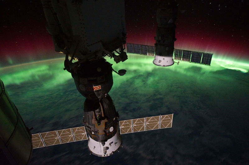
5. Europe and Africa, 28 October 2010. At the top of the picture - the "boot" of Italy and Sicily. Most of the visible water spaces are the Mediterranean Sea. To the right of the center is the Adriatic Sea. Part of Tunisia is visible on the left. In the foreground is a docked Russian ship and parts of the ISS. (NASA)
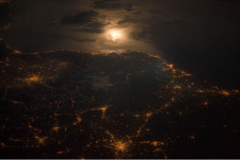
6. City lights near the Italian-French border, April 28, 2011. Torino (Italy), Lyon and Marseille (France) are the brightest. The island of Corsica is visible at the top of the picture. The surface of the water reflects bright light full moon. At the time the photo was taken, the ISS was over Luxembourg. Astronauts often take photographs in which moonlight reflected off the surface of the Earth is directed directly at them. That is, when photographing, they look forward, and not vertically at what is directly under the station. (NASA)
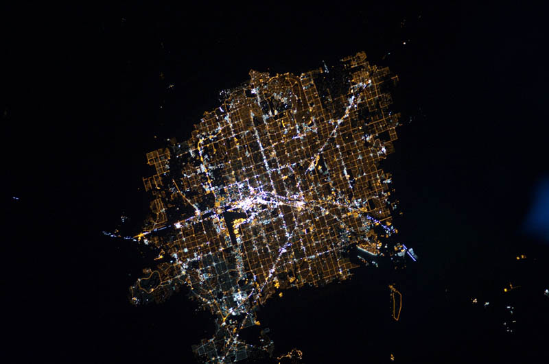
7. Las Vegas, Nevada, November 30, 2010 The dark desert is a contrasting background for the brightly lit regular network of city streets. The center of Las Vegas is considered the brightest place on Earth, due to the numerous lights of hotels and casinos. McCarran Airport and Nellis Air Force Base seem dark compared to the streets of the city. To take such a picture at night, the astronauts need to manually accompany the camera to the object being filmed, as the station moves at a speed of 7 km / s relative to the Earth's surface. (NASA)

9. Brasilia, Brazil, January 8, 2011 From orbit, the capital of Brazil cannot be confused with another city day or night. It is located on a plateau in the west-central part of the country and is considered one of the finest examples of urban planning of the 20th century. One of distinctive features city, when viewed from above, is the silhouette of a bird (or plane, or butterfly) moving from the northwest to the southeast. In the 1960s, other settlements began to grow around the city, and satellite cities soon appeared near the capital. Large unlit area in the lower left of the photo - Brazilian national park. Other dark areas are fields or tropical savanna. (NASA)
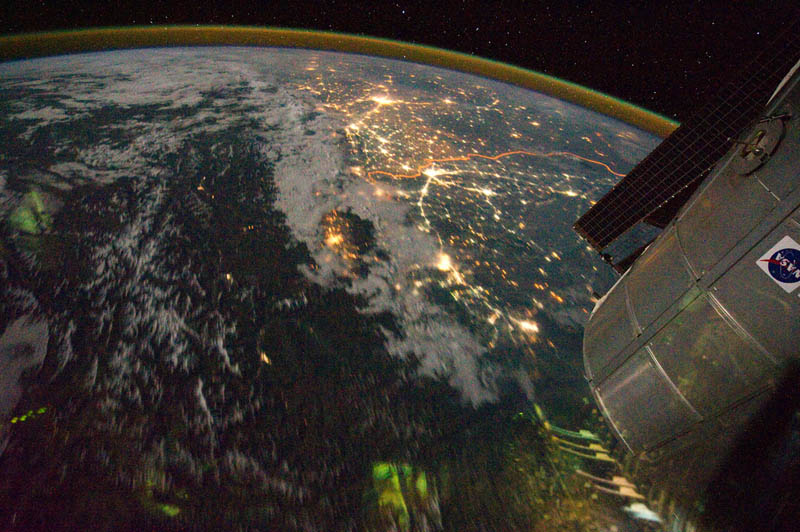
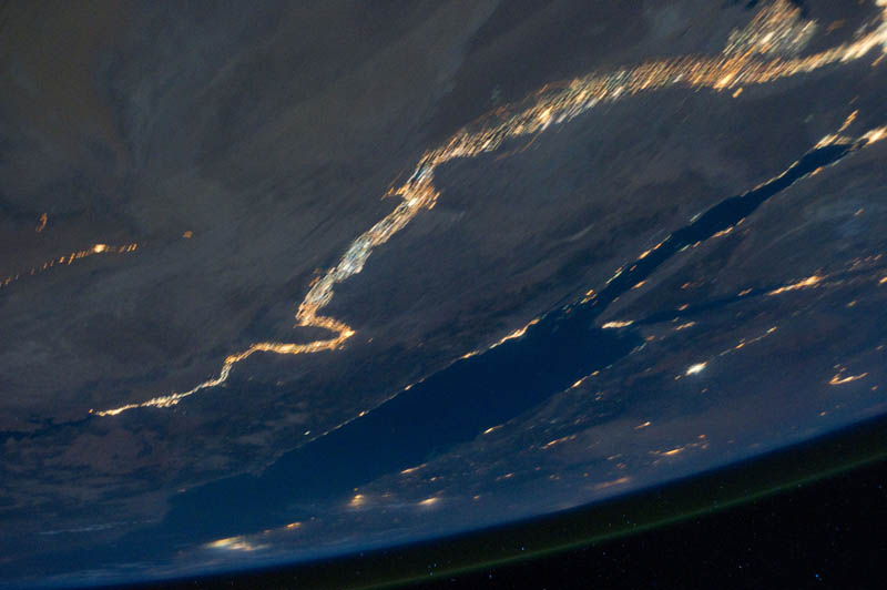
11. India-Pakistan border, August 21, 2011. On the Indo-Gangetic plain, out of hundreds of luminous spots, the largest are Islamabad (Pakistan) and New Delhi (India). These cities are located at a distance of about 700 km from each other. The roads connecting big cities. To the north (on the left side of the image) are the cloud-covered Himalayas. The orange stripe is the brightest part of the image - the India-Pakistan border. Barriers and bright lighting on it are designed to prevent smuggling and illegal arms trade between countries. (NASA)
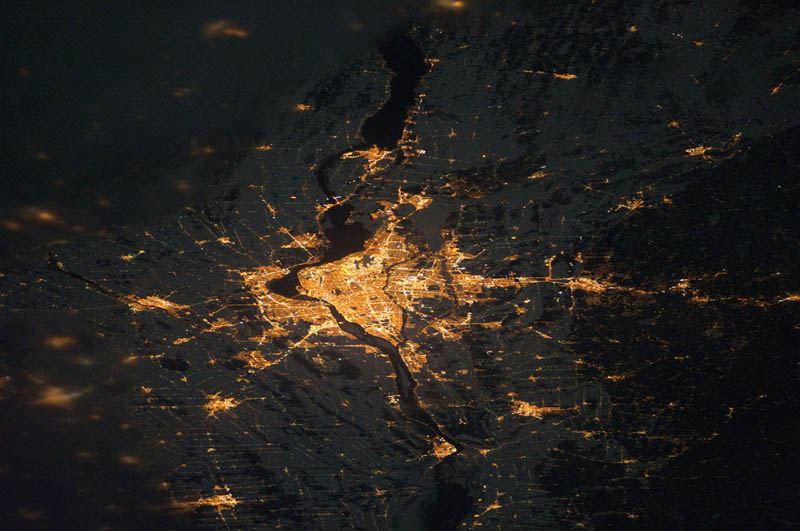
12. Montreal, December 24, 2010. Montreal is the most Big city French-speaking Quebec and second in the country after Toronto. Main roads and industrial areas are highlighted with white light, while residential and commercial areas are illuminated with golden yellow. Rivers and other bodies of water appear black, the earth is illuminated by moonlight. The blur on the left side of the photo is caused by cloudiness. (NASA)


14. Northwest Europe, August 10, 2011. London, Paris, Brussels and Amsterdam are clearly visible. Milan is also visible in the lower left. For scale, the centers of London and Paris are at a distance of 340 km. (NASA)


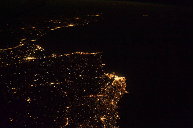
18. Atlantic coast of Europe and Africa, May 11, 2010. City lights can be traced from Lisbon, across the Strait of Gibraltar and down to the coast of Morocco, Casablanca. (NASA)
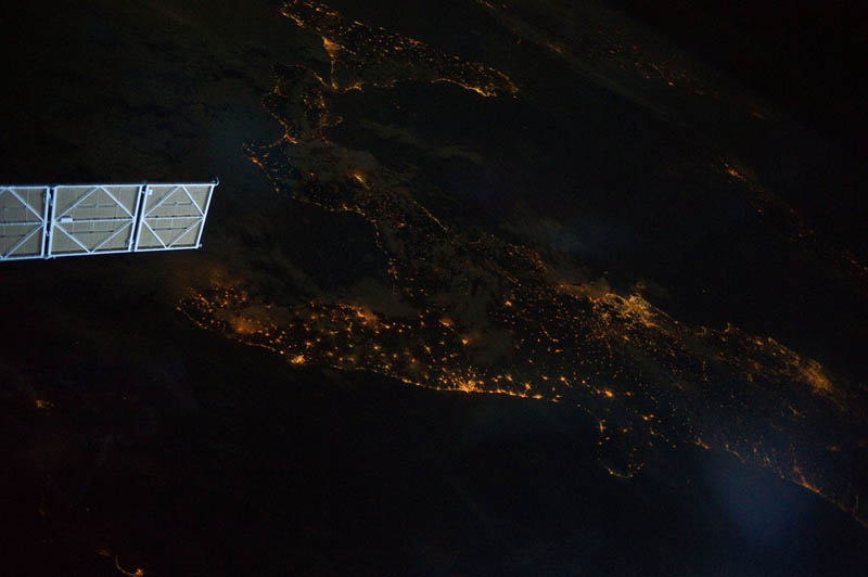
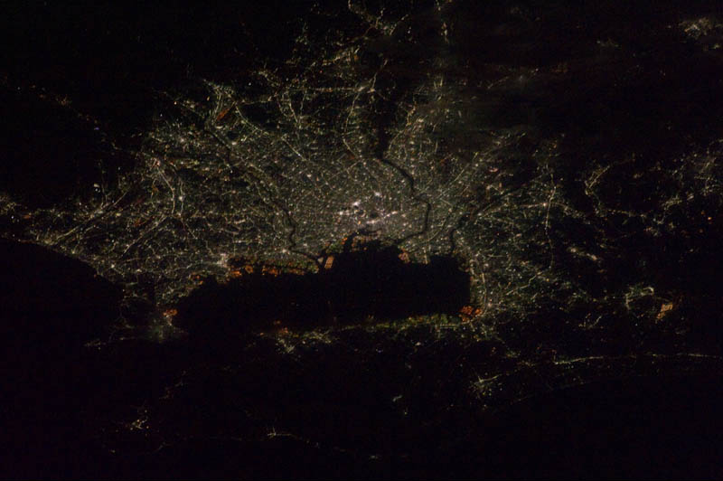
19. Southern part of Italy, June 11, 2011. The lower part of the "boot" and Sicily are illuminated by the lights of Naples, Bara and Brindisi. The Adriatic, Tyrrhenian and Ionian seas appear black. The lights of Palermo and Catania are visible in the lower center of the image. (NASA)
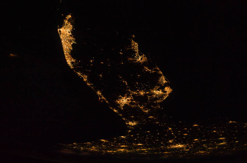
20. Florida Peninsula, December 28, 2010. On the left side (on the coast of the Atlantic Ocean), the lights of the brightly lit Cape Canaveral and the Kennedy Space Center are clearly visible. (NASA)
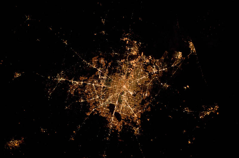
21. Houston, Texas, February 8, 2010 Houston is called the "energy capital of the world" because of its role in the production of gasoline and other energy products. Houston has an area of almost 2,331,000 hectares, with an average altitude of only 13 meters and a population of 5 million people. (NASA)

NASA astronomers presented A New Look to Earth: with the help of a recently launched satellite, they were able to show with unprecedented clarity what the planet looks like in dark time days. In addition to the "glow" of cities, super-sensitive equipment also captured the lights of ships plowing rivers at night, and torches in oil and gas fields, according to the NASA website.
NASA astronomers have presented a new view of the Earth: with the help of a recently launched satellite, they were able to show with unprecedented clarity what the planet looks like at night. Photo: nasa.gov
The Suomi NPP satellite, equipped with the ultra-sensitive VIIRS radiometer, was launched last year. To take a picture of every piece of land and all the islands, the satellite needed to circle the Earth 312 times. Pictures taken in cloudless weather in April and October 2012 were combined with photographs 40 years ago - then the Apollo 17 team took the famous photographs of the Earth, calling them "blue marble", specifies Reuters. By analogy, the current footage of the night planet was nicknamed "black marble".

For all the reasons we need to observe the Earth during the day, we need to observe it at night as well. Photo: nasa.gov
The Earth has been photographed from satellites for about 40 years (including for the purpose of weather forecasting). However, Suomi NPP is the first device that is designed to take pictures at night. "For all the reasons we need to observe the Earth during the day, we need to observe it at night as well," said Steve Miller of the Suomi NPP satellite. "Unlike humans, the Earth never sleeps," Miller added.

Unlike humans, the Earth never sleeps. Photo: nasa.gov
At first glance at the night planet, it is noticeable that it glows extremely heterogeneously: "In some places, the luminous city resembles a lone star in the night sky, in others it is a dense cluster of galaxies," NASA notes.
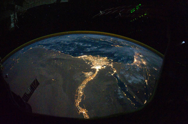
Surprisingly, navigable rivers are highlighted - for example, the Nile is very different from the general background. Also at night from space it is clear that humanity is still limited to natural landscapes, NASA notes, showing a view from above of the Himalayas. In addition, the "black marble" reflected in some way political problems. modern world: for example, the Northern and South Korea, and in the Middle East there are clusters of lights - torches in oil and gas developments, the authors explain.
The device has already been tested for meteorological purposes: Suomi NPP presented scientists with a top view of Hurricane Sandy, which hit the US east coast on October 29. The satellite camera also captured the impact of the elements, because in the first days of the storm, millions of people were left without electricity, and there were significantly fewer lights at night.
In order to capture such unparalleled clarity at night, the satellite's equipment operates differently than a conventional camera. Suomi NPP cameras take pictures of the opening panorama in small areas, and then these pixels are combined into an overall picture. Each fragment is considered separately - if the frame turned out to be too dark or too light, it has to be finalized to the desired quality. In addition, three cameras operate simultaneously on the satellite so that the best shot can be selected.

Night glow of Europe, Asia and Africa in the image of the Suomi-NPP satellite. (NASA Earth Observatory)

Northern and South America. (NASA Earth Observatory)

Asia, Australia and Oceania. (NASA Earth Observatory)

Glowing map of the world. (NASA Earth Observatory/NOAA NGDC)

Night glow of Western Europe. (NASA Earth Observatory)
NASA astronomers have presented a new view of the Earth: with the help of a recently launched satellite, they were able to show with unprecedented clarity what the planet looks like at night. In addition to the "glow" of cities, super-sensitive equipment also captured the lights of ships plowing rivers at night, and torches in oil and gas fields, according to the NASA website.
NASA astronomers have presented a new view of the Earth: with the help of a recently launched satellite, they were able to show with unprecedented clarity what the planet looks like at night. Photo: nasa.gov
The Suomi NPP satellite, equipped with the ultra-sensitive VIIRS radiometer, was launched last year. To take a picture of every piece of land and all the islands, the satellite needed to circle the Earth 312 times. Pictures taken in cloudless weather in April and October 2012 were combined with photographs 40 years ago - then the Apollo 17 team took the famous photographs of the Earth, calling them "blue marble", specifies Reuters. By analogy, the current footage of the night planet was nicknamed "black marble".
For all the reasons we need to observe the Earth during the day, we need to observe it at night as well. Photo: nasa.gov
The Earth has been photographed from satellites for about 40 years (including for the purpose of weather forecasting). However, Suomi NPP is the first device that is designed to take pictures at night. "For all the reasons we need to observe the Earth during the day, we need to observe it at night as well," said Steve Miller of the Suomi NPP satellite. "Unlike humans, the Earth never sleeps," Miller added.
Unlike humans, the Earth never sleeps. Photo: nasa.gov
At first glance at the night planet, it is noticeable that it glows extremely heterogeneously: "In some places, the luminous city resembles a lone star in the night sky, in others it is a dense cluster of galaxies," NASA notes.
Surprisingly, navigable rivers are highlighted - for example, the Nile is very different from the general background. Also at night from space it is clear that humanity is still limited to natural landscapes, NASA notes, showing a view from above of the Himalayas. In addition, "black marble" reflected in some way the political problems of the modern world: for example, North and South Korea contrast sharply in the pictures, and clusters of lights - torches on oil and gas developments stand out in the Middle East, the authors explain.
The device has already been tested for meteorological purposes: Suomi NPP presented scientists with a top view of Hurricane Sandy, which hit the US east coast on October 29. The satellite camera also captured the impact of the elements, because in the first days of the storm, millions of people were left without electricity, and there were significantly fewer lights at night.
In order to capture such unparalleled clarity at night, the satellite's equipment operates differently than a conventional camera. Suomi NPP cameras take pictures of the opening panorama in small areas, and then these pixels are combined into an overall picture. Each fragment is considered separately - if the frame turned out to be too dark or too light, it has to be finalized to the desired quality. In addition, three cameras operate simultaneously on the satellite so that the best shot can be selected.
Night glow of Europe, Asia and Africa in the image of the Suomi-NPP satellite. (NASA Earth Observatory)
North and South America. (NASA Earth Observatory)
Asia, Australia and Oceania. (NASA Earth Observatory)
Glowing map of the world. (NASA Earth Observatory/NOAA NGDC)
Night glow of Western Europe. (NASA Earth Observatory)


