Which moves with a certain cyclicity and frequency. Differs in constancy physical and chemical properties and specific geographic location. It can be cold or warm, depending on belonging to the hemispheres. Each such flow is characterized by increased density and pressure. The flow rate of water masses is measured in sverdrupa, in a broader sense - in units of volume.
Varieties of currents
First of all, cyclically directed water flows are characterized by such features as stability, speed, depth and width, Chemical properties, influencing forces, etc. Based on the international classification, there are three categories of flows:
1. Gradient. Occur when exposed to isobaric layers of water. A gradient ocean current is a flow characterized by horizontal movements of the isopotential surfaces of the water area. According to their initial features, they are divided into density, baric, stock, compensation and seiche. As a result of the runoff flow, precipitation and ice melting are formed.
2. Wind. Determined by the slope of the sea level, the strength of the air flow and fluctuations in mass density. A subspecies is drifting. This is a flow of water caused purely by the action of the wind. Only the surface of the pool is exposed to oscillations.
3. Tidal. They appear most strongly in shallow water, in estuaries and near the coast.
A separate type of flow is inertial. It is caused by the action of several forces at once. According to the variability of movement, constant, periodic, monsoon and trade wind flows are distinguished. The last two are determined by direction and speed seasonally.
Causes of ocean currents
At the moment, the circulation of waters in the world's waters is only beginning to be studied in detail. By and large, specific information is known only about surface and shallow currents. The main snag is that the oceanographic system has no clear boundaries and is in constant motion. It is a complex network of flows due to various physical and chemical factors.
Nevertheless, the following causes of ocean currents are known today:
1. Cosmic impact. This is the most interesting and at the same time difficult to learn process. In this case, the flow is determined by the rotation of the Earth, the impact on the atmosphere and hydrological system of the planet of cosmic bodies, etc. A striking example is the tides.
2. Wind exposure. The circulation of water depends on the strength and direction of air masses. In rare cases, we can talk about deep currents.
3. Density difference. Streams are formed due to uneven distribution of salinity and temperature of water masses.
atmospheric effect
In the world's waters, this kind of influence is caused by the pressure of heterogeneous masses. Coupled with cosmic anomalies, water flows in the oceans and smaller basins change not only their direction, but also their power. This is especially noticeable in the seas and straits. A prime example can serve as the Gulf Stream. At the beginning of his journey, he is characterized by increased speed.

During the Gulf Stream, it is accelerated simultaneously by opposite and fair winds. This phenomenon forms a cyclic pressure on the layers of the pool, accelerating the flow. From here, in a certain period of time, there is a significant outflow and inflow of a large amount of water. The lower the atmospheric pressure, the higher the tide.
When the water level drops, the slope of the Florida Strait becomes less. Because of this, the flow rate is significantly reduced. Thus, it can be concluded that increased pressure reduces the force of the flow.
wind impact
The connection between the flows of air and water is so strong and at the same time simple that it is hard not to notice even with the naked eye. Since ancient times, navigators have been able to calculate the appropriate ocean current. This became possible thanks to the work of the scientist W. Franklin on the Gulf Stream, dating back to the 18th century. A few decades later, A. Humboldt indicated precisely the wind in the list of the main extraneous forces affecting the water masses.

From a mathematical point of view, the theory was substantiated by the physicist Zeppritz in 1878. He proved that in the World Ocean there is a constant transfer of the surface layer of water to deeper levels. In this case, the wind becomes the main influencing force on the movement. The current velocity in this case decreases in proportion to the depth. The determining condition for the constant circulation of waters is an infinitely long time of action of the wind. The only exceptions are the trade winds of air, which cause the movement of water masses in the equatorial strip of the World Ocean seasonally.
Density difference
The impact of this factor on water circulation is the most important cause of currents in the World Ocean. Large-scale studies of the theory were carried out by the international expedition Challenger. Subsequently, the work of scientists was confirmed by Scandinavian physicists.
The heterogeneity of the densities of water masses is the result of several factors at once. They have always existed in nature, representing a continuous hydrological system of the planet. Any deviation in water temperature entails a change in its density. In this case, it is always observed back proportional dependence. The higher the temperature, the lower the density.
Also, the difference in physical indicators is affected by state of aggregation water. Freezing or evaporation increases density, precipitation decreases it. Affects the strength of the current and salinity of water masses. It depends on the melting of ice, precipitation and the level of evaporation. In terms of density, the World Ocean is quite uneven. This applies to both surface and deep layers of the water area.
Currents of the Pacific Ocean
The general scheme of flows is determined by the circulation of the atmosphere. Thus, the east trade wind contributes to the formation of the North Current. It crosses the waters from the Philippine Islands to the coast of Central America. It has two branches that feed the Indonesian Basin and the Equatorial Ocean Current Pacific Ocean.

The largest currents in the water area are the Kuroshio, Alaska and California currents. The first two are warm. The third stream is the cold ocean current of the Pacific Ocean. The basin of the Southern Hemisphere is formed by the Australian and Tradewind currents. A little to the east of the center of the water area, the Equatorial countercurrent is observed. Off the coast South America there is a branch of the cold Peruvian current.
During the summer, the El Niño ocean current operates near the equator. It pushes back the cold masses of water of the Peruvian Stream, forming a favorable climate.
Indian Ocean and its currents
The northern part of the basin is characterized by a seasonal change of warm and cold flows. This constant dynamics is caused by the action of the monsoon circulation.
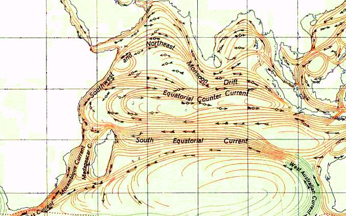
In winter, the Southwest Current dominates, which originates in the Bay of Bengal. A little further south is Western. It's an ocean current indian ocean crosses the water area from the coast of Africa to the Nicobar Islands.
In summer, the east monsoon contributes to a significant change in surface waters. The equatorial countercurrent shifts to a depth and noticeably loses its strength. As a result, its place is occupied by powerful warm Somali and Madagascar currents.
Arctic ocean circulation
The main reason for the development of the undercurrent in this part of the World Ocean is a powerful influx of water masses from the Atlantic. The fact is that the centuries-old ice cover does not allow the atmosphere and cosmic bodies to influence the internal circulation.

The most important course of the Arctic Ocean is the North Atlantic. It drives huge volumes of warm masses, preventing the water temperature from dropping to critical levels.
The Transarctic current is responsible for the direction of ice drift. Other major streams include the Yamal, Svalbard, North Cape and Norwegian currents, as well as a branch of the Gulf Stream.
currents of the atlantic basin
The salinity of the ocean is extremely high. The zonality of water circulation is the weakest among other basins.

Here the main ocean current is the Gulf Stream. Thanks to him, the average water temperature is kept at around +17 degrees. This warm ocean warms both hemispheres.
Also the most important streams of the basin are the Canary, Brazilian, Benguela and Tradewind currents.
All currents of the World Ocean are divided into surface and deep. They have different properties. There are 60 surface currents in the World Ocean.
general information
The main cause of surface currents in the oceans is the wind. Because of this, water flows are also called trade winds. There are several varieties of them:
- south trade wind;
- northern trade wind;
- inter-trade countercurrent.
Connecting, they form a ring, which is clearly visible on the current map. Since the occurrence of the surface currents of the World Ocean is associated with the blow of the winds, they are not always constant. Some currents come and go at certain times of the year. The pattern of surface currents coincides with the pattern of winds.

Rice. 1. Scheme of surface currents
How do current rings form? The trade winds move the water to the west, and the westerly winds move it to the east. In addition, the currents depend on the strength of the rotation of the planet, so they deviate to the right and left.
A surface current is considered to be a current that occupies no more than 350 m in depth.
in the atlantic ocean
There are north and south currents, as well as a countercurrent between them. The northern one originates from Cape Verde and comes to the Antilles, and from there it enters the Gulf of Florida. Then it enters the Gulf Stream.
TOP 3 articleswho read along with this
The southern current completely crosses the Atlantic Ocean, and off the coast of South America it splits into the Brazilian and Guiana. The cold Canary Current is forming off the coast of Africa.
The trade wind countercurrent can only be observed in summer.
In the Pacific
There are also north and south currents, and an inter-trade countercurrent. The northern one begins at the Philippine Islands and forms the Kuroshio Current. Opposite to it is the cold current Oyashio.
In the northern part of the ocean, the currents are unstable. In winter, the Southwest Current is observed here, going from the Bay of Bengal to East Africa. In summer, the Somali current is formed, passing in the opposite direction.

Rice. 2. Currents of the Pacific Ocean
In the Indian Ocean
The formation of surface currents in the Indian Ocean is influenced not only by the trade winds, but also by monsoon winds. Only one ring of surface currents is formed here - in the Southern Hemisphere. A large warm current is Madagascar. The main cold is Western Australian.

Rice. 3. The island of Madagascar in the Indian Ocean.
In the Arctic Ocean
There is one main current - the Antarctic Circumpolar. It is the largest in the oceans. This current crosses three oceans, covers vast water areas.
What have we learned?
On the surface of the oceans there is a large number of varied currents. Some of them are observed constantly, some are formed at certain times of the year. In general, the pattern of currents coincides with the pattern of winds.
Report Evaluation
Average rating: 3.9. Total ratings received: 27.
Reference table ocean currents contains information on the sea currents of the world ocean, warm, cold, current speed, temperature, salinity, in which ocean they flow. The information contained in the table can be used in independent work students of geographers and ecologists, when writing term papers and preparing manuals for every continent and part of the world.
Map of ocean currents
World ocean currents warm and cold table
|
ocean currents |
flow type |
Features of sea currents |
|
|
Alaska Current |
Neutral |
Pacific Ocean |
It flows in the northeastern part of the Pacific Ocean, is the northern branch of the North Pacific Current. It flows at great depths to the very bottom. Flow velocity from 0.2 to 0.5 m/s. Salinity 32.5 ‰. The temperature on the surface is from 2 to 15 C° depending on the season. |
|
Antilles Current |
Atlantic |
The warm current in the Atlantic Ocean is a continuation of the Trade Wind current, in the north it connects with the Gulf Stream. Speed 0.9-1.9 km/h. Surface temperature 25 to 28 C°. Salinity 37 ‰ |
|
|
Benguela current |
Cold |
Atlantic |
The cold Antarctic current that flows from the Cape of Good Hope to the Namib in Africa. The surface temperature is 8 C° below the average for these latitudes. |
|
brazilian |
Pacific Ocean |
A branch of the South Passat Current, flows along the coast of Brazil to the southwest in top layer water. The flow velocity is from 0.3 to 0.5 m/s. The temperature on the surface is from 15 to 28 C° depending on the season. |
|
|
East Australian |
Pacific Ocean |
It flows along the coast of Australia deviating to the south. average speed 3.6 - 5.7 km/h. Surface temperature ≈ 25 C° |
|
|
East Greenland |
Cold |
Arctic Ocean |
It flows along the coast of Greenland in a southerly direction. The flow velocity is 2.5 m/s. Surface temperature from<0 до 2 C°. Соленость 33 ‰ |
|
East Icelandic |
Cold |
Atlantic |
It flows along the eastern coast of the island of Iceland in a southerly direction. Temperature from -1 to 3 C°. Current speed 0.9 - 2 km/h. |
|
East Sakhalin Current |
Cold |
Pacific Ocean |
It flows along the eastern coast of Sakhalin in a southerly direction into the Sea of Okhotsk. Salinity ≈ 30 ‰. Surface temperature from -2 to 0 C°. |
|
Guiana Current |
Neutral |
Pacific Ocean |
It is a branch of the South Trade Wind and flows along the northeastern coast of South America. Speed > 3 km/h. Temperature 23-28 C°. |
|
Gulfstream |
Atlantic |
Warm current in the Atlantic Ocean, flows along the east coast North America. Powerful jet stream 70-90 km wide, flow rate 6 km/h, decreases at depth. The average temperature is from 25 to 26 C° (at a depth of 10 - 12 C°). Salinity 36 ‰. |
|
|
Western Australian |
Cold |
Indian |
It flows from south to north off the western coast of Australia, part of the current of the West Winds. The current speed is 0.7-0.9 km/h. Salinity 35.7‰. The temperature varies from 15 to 26 °C. |
|
West Greenland |
Neutral |
Atlantic, Arctic Oceans |
It flows along the western coast of Greenland in the Labrador and Baffin Seas. Speed 0.9 - 1.9 km/h. |
|
West Icelandic |
Cold |
Atlantic |
This is a branch of the East Greenland Current, which flows along the western coast of Greenland. The flow velocity is 2.5 m/s. Surface temperature from<0 до 2 C°. Соленость 33 ‰ |
|
needle flow |
Atlantic, Indian |
The Current of Cape Agulhas, the most stable and strongest current in the world's oceans. Runs along the east coast of Africa. Average speed up to 7.5 km/h (on the surface up to 2 m/s). |
|
|
Irminger |
Atlantic |
It flows not far from Iceland. Moves warm waters north. |
|
|
california |
Cold |
Pacific Ocean |
It is the southern branch of the North Pacific Current, flows from north to south along the California coast. Superficial. Speed 1-2 km/h. Temperature 15 -26C°. Salinity 33-34‰. |
|
Canadian current |
Cold |
Arctic |
|
|
canary current |
Cold |
Atlantic |
Passes along the Canary Islands, then passes into the North Equatorial Current. Speed 0.6 m/s. Width ≈ 500 km. Water temperature from 12 to 26 C°. Salinity 36 ‰. |
|
caribbean |
Atlantic |
Current in the Caribbean Sea, continuation of the north-trade current. Speed 1-3 km/h. Temperature 25-28 C°. Salinity 36.0‰. |
|
|
Kuril (Oyashio) |
Cold |
Pacific Ocean |
Also called Kamchatka, it flows along Kamchatka, the Kuril Islands and Japan. Speed from 0.25 m/s to 1 m/s. Width ≈ 55 km. |
|
Labrador |
Cold |
Atlantic |
It flows between Canada and Greenland to the south. Flow velocity 0.25 - 0.55 m/s. The temperature varies from -1 to 10C°. |
|
Madagascar Current |
Indian |
The surface current off the coast of Madagascar is a branch of the South Trade Wind Current. Average speed 2-3 km/h. Temperature up to 26 C°. Salinity 35 ‰. |
|
|
Intertrade countercurrent |
Powerful surface countercurrent between the North and South trade winds. They also include the Cromwell Current and the Lomonosov Current. The speed is very variable. |
||
|
Neutral |
Pacific Ocean |
||
|
mozambican |
Indian |
Surface current along the coast of Africa to the South in the Mozambia Strait. Branch of the South Trade Wind Current. Speed up to 3 km/h. Temperature up to 25 C°. Salinity 35‰. |
|
|
monsoon current |
Indian |
Caused by monsoon winds. Speed 0.6 - 1 m/s. In summer they change direction in the opposite direction. Average temperature 26C°. Salinity 35‰. |
|
|
New Guinea |
Pacific Ocean |
It flows in the Gulf of Guinea from west to east. The average temperature is 26 - 27C°. Average speed 2 km/h. |
|
|
norwegian current |
Arctic |
Current in the Norwegian Sea. The temperature is 4-12C° depending on the season. Speed 1.1 km/h. It flows at a depth of 50-100 meters. Salinity 35.2‰. |
|
|
North Cape |
Arctic |
A branch of the Norwegian Current along the northern coast of the Kola and Scandinavian Peninsulas. Is superficial. Speed 1 - 2 km/h. The temperature ranges from 1 to 9 C°. Salinity 34.5 - 35 ‰. |
|
|
Peruvian Current |
Cold |
Pacific Ocean |
Surface cold flow of the Pacific Ocean from south to north near the western coasts of Peru and Chile. Speed ≈ 1 km/h. Temperature 15-20 C°. |
|
seaside current |
Cold |
Pacific Ocean |
It flows from north to south from the Tatar Strait along the coasts of the Khabarovsk and Primorsky Territories. Salinity is low 5 - 15 ‰ (diluted with Amur water). Speed 1 km/h. The width of the stream is 100 km. |
|
Northern Tradewind (North Equatorial) |
Neutral |
Quiet, Atlantic |
In the Pacific Ocean, it is a continuation of the California current and passes into Kuroshio. In the Atlantic Ocean, it arises from the Canary Current and is one of the sources of the Gulf Stream. |
|
North Atlantic |
Atlantic |
A powerful surface warm current of the ocean, a continuation of the Gulf Stream. Influences the climate in Europe. Water temperature 7 - 15 C°. Speed from 0.8 to 2 km/h. |
|
|
North Pacific |
Pacific Ocean |
It is a continuation of the Kuroshio Current east of Japan. Moves to the shores of North America. The average speed slows down from 0.5 to 0.1 km/h. The temperature of the surface layer is 18 -23 C°. |
|
|
Somali Current |
Neutral |
Indian |
The current depends on the monsoon winds and flows near the Somali peninsula. The average speed is 1.8 km/h. Temperature in summer 21-25C°, in winter 25.5-26.5C°. Water consumption 35 Sverdrup. |
|
Pacific Ocean |
Current of the Sea of Japan. Temperature from 6 to 17 C°. Salinity 33.8-34.5 ‰. |
||
|
Taiwanese |
Pacific Ocean |
||
|
The course of the West Winds |
Cold |
Pacific, Atlantic, Indian oceans |
Antarctic Circumpolar Current. The surface cold large current of the ocean in the Southern Hemisphere, the only one that passes through all the meridians of the Earth from west to east. Caused by westerly winds. Average speed 0.4 - 0.9 km/h. The average temperature is 1 -15 °C. Salinity 34-35 ‰. |
|
The course of Cape Horn |
Cold |
Atlantic |
Surface cold current in Deyka Prospect near the western shores of Tierra del Fuego. Speed 25-50 cm/s. Temperature 0-5 °C. Brings icebergs in summer. |
|
Transarctic |
Cold |
Arctic |
The main course of the Arctic Ocean is caused by the runoff of the rivers of Asia and Alaska. carries ice from Alaska to Greenland. |
|
Florida current |
Neutral |
Atlantic |
It flows along the southeast coast of Florida. Continuation of the Caribbean current. Average speed 6.5 km/h. Carries a volume of water in the amount of 32 Sv. |
|
Falkland Current |
Cold |
Atlantic |
The surface cold current of the ocean flows along the southeastern coast of South America. The average temperature ranges from 4 to 15 °C. Salinity 33.5 ‰. |
|
Svalbard |
Arctic |
The warm current of the ocean near the western shores of arch. Svalbard. Average speed 1 - 1.8 km/h. Temperature 3-5°C. Salinity 34.5 ‰ |
|
|
El Niño |
Pacific Ocean |
This is the process of fluctuations in the temperature of the surface layer of waters in the equatorial part of the Pacific Ocean. |
|
|
South Passatnoye |
Neutral |
Pacific, Atlantic, Indian oceans |
Warm currents of the oceans. In the Pacific Ocean, it starts from the coast of South America and goes west to Australia. In the Atlantic - is a continuation of the Benguela Current. In the Indian Ocean, a continuation of the West Australian Current. Temperature ≈ 32 °C. |
|
Japanese (Kuroshio) |
Pacific Ocean |
It flows off the eastern coast of Japan. Current speed from 1 to 6 km/h. The average water temperature is 25 - 28°C, in winter 12 -18°C. |
_______________
The source of information: Reference manual "Physical geography of continents and oceans". - Rostov-on-Don, 2004
Navigators learned about the presence of ocean currents almost immediately, as soon as they began to surf the waters of the oceans. True, the public paid attention to them only when, thanks to the movement of ocean waters, many great geographical discoveries were made, for example, Christopher Columbus sailed to America thanks to the North Equatorial Current. After that, not only sailors, but also scientists began to pay close attention to ocean currents and strive to explore them as best and as deeply as possible.
Already in the second half of the XVIII century. sailors studied the Gulf Stream quite well and successfully applied their knowledge in practice: they went with the flow from America to Great Britain, and kept a certain distance in the opposite direction. This allowed them to be two weeks ahead of ships whose captains were not familiar with the terrain.
Oceanic or sea currents are large-scale movements of the water masses of the World Ocean at a speed of 1 to 9 km / h. These streams do not move randomly, but in a certain channel and direction, which is the main reason why they are sometimes called the rivers of the oceans: the width of the largest currents can be several hundred kilometers, and the length can reach more than one thousand.
It has been established that water flows do not move straight, but deviating slightly to the side, they obey the Coriolis force. In the Northern Hemisphere they almost always move clockwise, in the Southern Hemisphere it is vice versa.. At the same time, currents located in tropical latitudes (they are called equatorial or trade winds) move mainly from east to west. The strongest currents were recorded along the eastern coasts of the continents.
Water flows do not circulate on their own, but they are set in motion by a sufficient number of factors - the wind, the rotation of the planet around its axis, the gravitational fields of the Earth and the Moon, the bottom topography, the outlines of continents and islands, the difference in temperature indicators of water, its density, depth in various places of the ocean and even its physico-chemical composition.
Of all types of water flows, the most pronounced are the surface currents of the World Ocean, the depth of which is often several hundred meters. Their occurrence was influenced by trade winds, constantly moving in tropical latitudes in a west-east direction. These trade winds form huge streams of the North and South Equatorial currents near the equator. A smaller part of these flows returns to the east, forming a countercurrent (when the movement of water occurs in the opposite direction from the movement of air masses). Most, colliding with the continents and islands, turns to the north or south.
Warm and cold water streams
It must be taken into account that the concepts of "cold" or "warm" currents are conditional definitions. So, despite the fact that the temperature indicators of the water flows of the Benguela Current, which flows along the Cape of Good Hope, are 20 ° C, it is considered cold. But the North Cape Current, which is one of the branches of the Gulf Stream, with temperatures ranging from 4 to 6 ° C, is warm.


This happens because the cold, warm and neutral currents got their names based on a comparison of the temperature of their water with the temperature indicators of the ocean surrounding them:
- If the temperature indicators of the water flow coincide with the temperature of the waters surrounding it, such a flow is called neutral;
- If the temperature of the currents is lower than the surrounding water, they are called cold. They usually flow from high latitudes to low latitudes (for example, the Labrador Current), or from areas where, due to the large flow of rivers, ocean water has a reduced salinity of surface water;
- If the temperature of the currents is warmer than the surrounding water, then they are called warm. They move from the tropics to subpolar latitudes, such as the Gulf Stream.
Main water flows
At the moment, scientists have recorded about fifteen major oceanic water flows in the Pacific, fourteen in the Atlantic, seven in the Indian and four in the Arctic Ocean.
It is interesting that all the currents of the Arctic Ocean move at the same speed - 50 cm / s, three of them, namely the West Greenland, West Svalbard and Norwegian, are warm, and only the East Greenland belongs to the cold current.
But almost all the oceanic currents of the Indian Ocean are warm or neutral, while the Monsoon, Somali, West Australian and the Cape of Needles (cold) move at a speed of 70 cm / s, the speed of the rest varies from 25 to 75 cm / s. The water flows of this ocean are interesting because, along with the seasonal monsoon winds, which change their direction twice a year, ocean rivers also change their course: in winter they mainly flow west, in summer - east (a phenomenon characteristic only of the Indian Ocean). ).
Since the Atlantic Ocean stretches from north to south, its currents also have a meridional direction. Water streams located in the north move clockwise, in the south - against it.


A striking example of the flow of the Atlantic Ocean is the Gulf Stream, which, starting in the Caribbean Sea, carries warm waters to the north, breaking up into several side streams along the way. When the waters of the Gulf Stream end up in the Barents Sea, they enter the Arctic Ocean, where they cool and turn south in the form of a cold Greenland current, after which at some stage they deviate to the west and again adjoin the Gulf Stream, forming a vicious circle.
The currents of the Pacific Ocean are mainly latitudinal and form two huge circles: northern and southern. Since the Pacific Ocean is extremely large, it is not surprising that its water flows have a significant impact on most of our planet.
For example, trade winds move warm water from the western tropical coasts to the eastern ones, which is why the western part of the Pacific Ocean in the tropical zone is much warmer than the opposite side. But in the temperate latitudes of the Pacific Ocean, on the contrary, the temperature is higher in the east.
deep currents
For quite a long time, scientists believed that the deep ocean waters were almost motionless. But soon, special underwater vehicles discovered both slow and fast-flowing water flows at great depths.
For example, under the Equatorial Pacific Ocean at a depth of about one hundred meters, scientists have identified the Cromwell underwater stream, moving eastward at a speed of 112 km / day.
A similar movement of water flows, but already in the Atlantic Ocean, was found by Soviet scientists: the width of the Lomonosov current is about 322 km, and the maximum speed of 90 km / day was recorded at a depth of about one hundred meters. After that, another underwater stream was discovered in the Indian Ocean, however, its speed turned out to be much lower - about 45 km / day.
The discovery of these currents in the ocean gave rise to new theories and mysteries, the main of which is the question of why they appeared, how they formed, and whether the entire ocean area is covered by currents or there is a point where the water is still.
The influence of the ocean on the life of the planet
The role of ocean currents in the life of our planet cannot be overestimated, since the movement of water flows directly affects the planet's climate, weather, and marine organisms. Many compare the ocean to a huge heat engine powered by solar energy. This machine creates a continuous water exchange between the surface and deep layers of the ocean, providing it with oxygen dissolved in water and affecting the life of marine life.
This process can be traced, for example, by considering the Peruvian Current, which is located in the Pacific Ocean. Thanks to the rise of deep waters, which lift phosphorus and nitrogen upward, animal and plant plankton successfully develop on the ocean surface, as a result of which the food chain is organized. Plankton is eaten by small fish, which, in turn, becomes a victim of larger fish, birds, marine mammals, which, with such food abundance, settle here, making the region one of the most highly productive areas of the World Ocean.
It also happens that a cold current becomes warm: the average ambient temperature rises by several degrees, which causes warm tropical showers to fall on the ground, which, once in the ocean, kill fish accustomed to cold temperatures. The result is deplorable - a huge amount of dead small fish ends up in the ocean, large fish leave, fishing stops, birds leave their nests. As a result, the local population is deprived of fish, crops that were beaten by downpours, and profits from the sale of guano (bird droppings) as fertilizer. It can often take several years to restore the former ecosystem.
Sea currents have a significant impact on the climate not only of the coasts along which they flow, but also on weather changes on a global scale. In addition, sea currents are of great importance for navigation. This is especially true for yachting, they affect the speed and direction of movement of both sailboats and motorized vessels.
To select the optimal route in one direction or another, it is important to know and take into account the nature of their occurrence, the direction and speed of the current. This factor should be taken into account when charting the movement of the ship both near the coast and on the high seas.
Classification of sea currents
All sea currents, depending on their characteristics, are divided into several types. Classification of sea currents as follows:
- By origin.
- By sustainability.
- By depth.
- By type of movement.
- By physical properties (temperature).
Reasons for the formation of sea currents
Formation of sea currents depends on a number of factors that have a complex effect on each other. All causes are conditionally divided into external and internal. The first ones include:
- Tidal gravitational influence of the Sun and Moon on our planet. As a result of these forces, not only daily tides and tides arise on the coast, but also steady movements of water volumes in the open ocean. The gravitational influence in one way or another affects the speed and direction of movement of all ocean currents.
- The action of winds on the sea surface. Winds blowing in one direction for a long time (for example, trade winds) inevitably transfer part of the energy of the moving air masses to surface waters, dragging them along. This factor can cause the appearance of both temporary surface flows and stable movements of huge masses of water - the Trade Wind (Equatorial), Pacific and Indian oceans.
- The difference in atmospheric pressure in different parts of the ocean, bending the water surface in a vertical direction. As a result, there is a difference in water level, and, as a result, sea currents are formed. This factor leads to the appearance of temporary and unstable surface flows.
- Wastewater flows occur when sea levels fluctuate. A classic example is the Florida Current flowing out of the Gulf of Mexico. The water level in the Gulf of Mexico is significantly higher than in the Sargasso Sea adjacent to it from the northeast due to the surge of water into the Gulf by the Caribbean current. As a result, a stream arises, rushing through the Florida Strait, and giving rise to the famous Gulf Stream.
- Runoff from mainland coasts can also cause steady currents. As an example, one can cite powerful streams that arise at the mouths of large rivers - the Amazon, La Plata, Yenisei, Ob, Lena, and penetrate hundreds of kilometers into the open ocean in the form of desalinated streams.

Internal factors include uneven density of water volumes. For example, increased evaporation of moisture in the tropical and equatorial regions leads to a higher concentration of salts, and in regions of heavy rainfall, salinity, on the contrary, is lower. The density of water also depends on the level of salinity. Temperature also has an effect on density; in higher latitudes or in deeper layers, the water is colder, and, therefore, denser.
Types of sea currents by stability
The next feature that allows classification of sea currents, is their stability. On this basis, the following types of sea currents are distinguished:
- Permanent.
- Fickle.
- Periodic.
Constants, in turn, depending on the speed and power are divided into:
- Powerful - Gulf Stream, Kuroshio, Caribbean.
- Medium - Atlantic and Pacific trade winds.
- Weak - California, Canary, North Atlantic, Labrador, etc.
- Local - have low speeds, small length and width. Often they are so weakly expressed that it is practically impossible to determine them without special equipment.
Periodic currents are currents that change direction and speed from time to time. At the same time, a certain cyclicity is manifested in their character, depending on external factors - for example, on the seasonal change in the direction of the winds (wind), the gravitational action of the Moon and the Sun (tidal), and so on.
If the change in direction, strength and speed of the flow is not subject to any repetitive patterns, they are called non-periodic. These include the emerging movements of water masses under the influence of atmospheric pressure differences, hurricane-force winds, accompanied by a surge of water.
Types of sea currents by depth
Movements of water masses occur not only in the surface layers of the sea, but also in its depths. On this basis, the types of sea currents are:
- Surface - pass in the upper layers of the ocean, up to 15 m deep. The main factor in their occurrence is the wind. It also affects the direction and speed of their movement.
- Deep - occur in the water column, below the surface, but above the bottom. The speed of their flow is lower than that of the surface ones.
- Bottom currents, as the name implies, flow in close proximity to the seabed. Due to the constant friction force of the soil acting on them, their speed is usually low.

Types of sea currents by the nature of the movement
Sea currents differ among themselves and in the nature of their movement. On this basis, they are divided into three types:
- Meandering. They have a sinuous, in a horizontal direction, character. The bends formed in this case are called “meanders”, similar to the Greek ornament of the same name. In some cases, meanders can form eddies along the edges of the main flow, up to hundreds of kilometers long.
- Rectilinear. They are characterized by a relatively rectilinear nature of movement.
- Circular. They are closed circulation circles. In the northern hemisphere, they can go clockwise (“anticyclonic”) or against it (“cyclonic”). For the southern hemisphere, respectively, the order will be reversed - .

Classification of sea currents by their temperature
The main classification factor is sea current temperature. On this basis, they are divided into warm and cold. At the same time, the concepts of "warm" and "cold" are very arbitrary. For example, the North Cape, which is a continuation of the Gulf Stream, is considered warm, having an average temperature of 5-7 o C, but the Canary is classified as cold, despite the fact that its temperature is 20-25 o C.
The reason for this is that the temperature of the surrounding ocean is taken as the reference point. So, the 7-degree North Cape current invades the Barents Sea, which has a temperature of 2-3 degrees. And the temperature of the waters surrounding the Canary Current, in turn, is several degrees higher than in the current itself. However, there are also such currents, the temperature of which practically does not differ from the temperature of the surrounding waters. These include the North and South trade winds and the current of the West winds around the Antarctic.