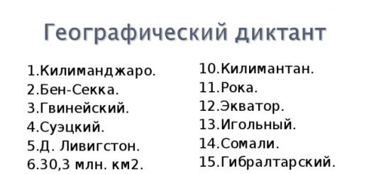
Game exercise system
Stage I
(Classes for children 4 years old)
1. Exercises performed in a group room and at home:
“Show and name what is in front (behind, left, right)”;
“Explain where the toy is”;
“Take the pyramid and put it on the shelf on the right”;
Task: find a toy in the room according to the verbal instructions of an adult (for example: “Go straight, turn left at the table, go to the outer window and look for the doll on the right”);
Various tasks to find an object according to the number of steps.
2. Similar tasks performed on the territory of the kindergarten and in the courtyard of the house:
Introductory tour of the kindergarten site and the yard of the house (task: to formulate where everything is located in relation to the child);
Finding a toy according to the verbal instructions of an adult (for example: “Walk straight along the path to the sandbox, turn left, go to the house, there you will find a toy”).
Stage II
(Classes for children 5 years old)
1. Working with a model of a doll’s room with furniture (joint examination of the doll’s room and depicting it to adults using simple geometric shapes).
2. Creation by adults, with the active help of children, of a map diagram of a play or living room, the boundaries of which are walls with windows and doors.
3. Conversation with examination of the map diagram of the premises. Tasks: show and name an object in the room, find its image on a map (you can use color as an assistant).
4. Children individually draw up a diagram of the group or their room on a sheet of paper. (Adult assistance is required in maintaining the scale of the diagram.)
5. Exercises with a diagram map.
The adult draws with a dotted line on the diagram map the route that the child is asked to “go” along.
Competition: who will complete their route faster and more accurately.
Important Tips:
when moving, the map-scheme must be held in front of you so that its main details - walls, windows, doors - coincide with their actual location;
constant reference point: look at the door first.
Games “Find where the toys are hidden”, “Arrange the toys as indicated on the diagram map.”
6. Orientation at the kindergarten site (in the courtyard of the house).
Studying the symbols of trees, bushes, equipment, coloring of symbols.
Drawing up a site plan for adults and children.
Exercises: “Walk along our site from the veranda to the sandbox, moving in accordance with the arrows shown on the map,” “How to get from the veranda to the sandbox?”
Joint drawing up by adults and children of a schematic map of two or three group areas.
Drawing up “small” maps by every child who wishes.
Game with a card.
The site is conventionally divided into 4 routes: for example, red, blue, yellow, green. Objects or toys familiar to children in the indicated four colors are placed along the routes as landmarks. On the schematic map, the routes are depicted with color signs corresponding to the placed landmarks, which at the same time serve as turn signals along the route.
Each team member (a team of about four children) is given a map with the upcoming route marked on it. Children must follow their route, remember landmarks, and then draw them with felt-tip pens on a general map. You can also cycle along the route.
Independent games like “Cossacks-Robbers”: one of the teams runs away, marking its direction with arrows, the other looks for it.
Stage III
(Classes for children 6 years old)
1. Study of a map-scheme drawn up by adults of the entire territory of the kindergarten (you can focus on several map options).
2. Joint drawing up of a map of the kindergarten territory by adults and children.
3. Orienteering exercises using miniature maps. First, the place of “start” and “finish” is a door, gate or gate, then other landmarks.
"Street Labyrinths"
"Beast Hunting" Pictures depicting various predatory animals are attached to small cardboards. The pictures are placed on the territory of the kindergarten, serving as route markers. The list of animals on a particular route is sketched by the teacher on a control card. As they progress along the route, children collect pictures of animals and give them to an adult to evaluate the completion of the task.
Exercises to develop memory: a part of the kindergarten territory is covered on the map and children are asked to draw it from memory.
Treasure Hunt game. Children are given a map diagram of two areas indicating the point where the “treasure” is hidden. You need to find the “treasure” according to the plan.
Competition games on bicycles along the route.
Game “Traffic Light”: participants follow the map in the hands of an adult: “green” means fast running, “yellow” means slow, “red” means stopping.
Games: “The most observant”, “Who is faster”, “Pathfinders”, “Don’t get lost”, “Find and remember”, “The most attentive”.
4. Introducing the compass.
Examination, examination, and a story from an adult about the design of the device and its purpose.
Exercises and games with a compass (choosing the direction of movement using a compass).
5. Orientation by the sun, moon, stars.
6. Orientation by natural phenomena and objects.
7. Orienteering competitions in the kindergarten area.
8. Tourist walks to nearby parks.
9. Family hiking trips (walking, cycling, driving).
10. Possible prospect: holding a family tourist gathering.
Olga SAPOZHNIKOVA,
senior teacher of preschool educational institution No. 213,
Rostov-on-Don
Svetlana Romanova
Classes for children of the older age group to familiarize themselves with spatial relationships “Gifted Child”
Subject "School of Cartographers"
Program content:
Systematize children's knowledge about spatial relations and methods of orientation using a compass, globe and geographical map, give children the concept "parts of the world": north, west, east, south:
To increase level educational activity in children through the organization of search activities with a compass and a geographical map. Continue to develop children's interest in acquiring new knowledge about the use of navigation skills in everyday life by people of different professions.
Continue work on developing the intellectual sphere preschoolers: teach children to plan and coordinate actions to obtain the desired result, as well as analyze the resulting result of joint work using existing skills in experimental work.
Continue to develop children's communication skills through joint search activities.
Introduce names and terms: compass, magnet, north, west, east, south, cardinal directions, cartographer. Explain the meaning expressions: "get your bearings", "graphic plan".
Materials for occupation:
Technical means training: TV, computer, interactive whiteboard.
Demo: video recording of an excerpt from a cartoon "Smeshariki", "Cartography"; drawing of the map of Smeshariki; measurements (tape, strip of paper, string, wooden stick, chips; presentation "The History of the Invention of the Compass"; drawing "Rose of Wind", globe, geographical atlas.
Dispensing: for everyone child pencils, cards, compasses, 5 circles from dense cardboard with a diameter of about 1.5 cm, 5 magnetized needles, a container for water.
Previous work: introducing children to a geographical atlas and natural areas; organization of role-playing games using various constructors on the topic "Travelers and Seafarers"; orientation using graphic plans of premises, made on paper at different scales, for the premises of the second floor of the kindergarten; use of computer games for orientation in space and familiarization with the surroundings; introducing preschoolers to various types of transport and means of transportation.
Progress of the lesson:
The teacher enters group with a toy“Smeshariki. Nyusha", refers to children:
Educator: - Guys, Nyusha came to visit us today. You know, Nyusha really wanted to be with you today see you, she has something for you request. One not very pleasant story happened to her back in the fall, but why tell it, let’s remember it together.
(View excerpt from an animated film "Smeshariki", "Cartography")
Educator: - Guys, I’ll show you the map that Nyusha the Hedgehog drew once again, and you will show me Tell: Why didn’t Nyusha find the mushroom clearing according to the drawn map? Let's take a look and find out what was not indicated on the map? Was the route given correctly?
Nyusha:- Yes, guys, tell me why?
(An image of the Hedgehog’s map appears on the screen. Children express their guesses why it is so difficult to use such an inaccurate by card: it’s difficult to navigate on such a map (correlate it with the site); directions are not indicated on the map; landmarks are not clearly indicated (stream, spring, cliff); conditionals are unclear object designations; the distance from one object to another is not indicated)
Educator: - Guys, if you don’t have the skill to use adult measuring instruments (ruler, meter, tape measure), then how can you measure the distance between landmarks?
Nyusha: - You know, guys, after such an unsuccessful search for mushrooms and "help" Smeshariki's friends in drawing maps, I want to learn how to draw maps myself. Please teach me how to properly use a map, indicate directions, move in indicated directions, and measure distances. And most importantly, I want to learn how to find a way out of a difficult situation the way you can, and do it all thoughtfully, having discussed the solution question with friends.
Educator: - Guys, do you agree to help Nyusha? Let's first tell Nyusha about the sequence of drawing up a route using the Hedgehog map as an example.
(The teacher invites the children to sit on the carpet in the center group room, look at the map and tell Nyusha:
Is there an indication on the Yozhik map of the beginning of Nyusha’s route? (Nyusha's house)- the teacher places a dot on the map in the indicated place.
What was the first sign Nyusha should have reached? (up to 2 oaks)
What is the distance between the start of the route and the first turn? (it is not specified)
Did Hedgehog indicate which direction Nyusha should turn near the oak trees? (left)
What other landmarks did Hedgehog Nyusha name? (spring, stream, cliff, mushroom meadow)
Did Hedgehog indicate the distances between them? (did not indicate)
What denote drawings on the map along Nyusha's path? (Christmas trees, trees,
Educator: - Guys, do you think we can help Nyusha correct the inaccuracies on the map? What can you offer Nyusha? (children's answers)
Educator: - Guys, I want to invite you to model the Hedgehog card on our carpet, we can arrange it in group all the landmarks indicated by Hedgehog, measure all the distances, draw a map on paper, and Nyusha will have to repeat all the actions, but on the ground, in her forest.
(The teacher places the indicated landmarks on the carpet (house, 2 oak trees, spring, cliff, mushroom meadow)
Educator: - Guys, check if we have arranged everything and tell me what measures we can use when measuring the distances between landmarks? (tape, strip of paper, string, stick, etc.).
Educator: - I want to invite you today to use such a measure as steps person: "short and long".
Educator: - Tell me, please, which steps are more convenient for us to use when measuring distances between landmarks and why? (short, we have very small distances between landmarks)
Educator: - What steps will be more convenient for Nyusha to use in the forest? (long, there the distances between landmarks are longer)
Educator: - I suggest you team up in pairs. Agree who in your pair will measure the distance and who will put aside the chips. Why do we need chips, what could be chips? (chips are needed to record how many measurements were taken on a given section of the path; chips can be any small objects.) And don’t forget, rule: a chip is placed at the end of each set aside measurement - today it will be the toe of your shoe. (The teacher places pairs of children between the indicated landmarks on the carpet (house - 2 oaks, 2 oaks - spring, spring - cliff, cliff - mushroom clearing. Children taking chips with them) begin to work)
Educator: - How far did the first couple travel from the beginning of the path to 2 oak trees? (children's answer)- How many measurements were taken from the second pair from 2 oak trees to the spring? (children's answers)- How many measurements were taken from the third pair from the spring to the cliff? (children's answers)- How many measurements were taken from the fourth pair from the cliff to the mushroom clearing? (children's answers)
Educator:- Nyusha, the guys learn something new and useful every time in order to become real cartographers. Do you know who they are "cartographers"? Guys, did you guess what? stands for word"cartographer"?
(Profession of adults associated with drawing maps)
Educator:- That’s right, cartography - (from Greek - "map" And- "paint") science of exploration, modeling and display spatial arrangement, combinations and relationships of objects and phenomena of nature and society.
The subjects of cartography are the Earth, celestial bodies, starry sky and the Universe. The result of the work of cartographers are figurative and symbolic models space in the form: flat maps, relief and volumetric maps, globes. They can be presented on solid, flat or voluminous materials (paper, plastic) or as an image on a video monitor.
Cartography probably appeared even before the advent of writing in primitive society. This is evidenced, for example, by the fact that peoples who did not have writing at the time of their discovery had developed cartographic skills. Travelers who asked the Eskimos of North America about the location of the surrounding islands and coasts received from them relatively clear descriptions, in the form of maps drawn on pieces of bark, on sand or on paper (if she was). Maps have been preserved in the form of rock paintings. First known maps belong to the sky, and not to the ground. Dots (rock art found on the walls of a cave in Turkey depict part of the night sky, three bright stars Vega, Deneb and Altair (constellation Summer Triangle).
The earliest maps in China were found during archaeological excavations of tombs, these were silk maps, and maps drawn in black ink on wooden blocks.
(Display of the oldest maps on blackboard: Turin papyrus map - the oldest paper map in the world; Babylonian world map.)
Educator:- Guys, would you like to know the secrets of cartographers when drawing up maps? If you don’t know these secrets, then you and I will end up with a map very similar to the Smeshariki map. I invite you and Nyusha to "School of Cartographers".
(Children are invited to sit at the table)
Educator:- To accurately depict maps, since ancient times, people have determined the cardinal directions (west, north, east, south): approximate south direction according to the position of the sun at zenith, east - according to the place of sunrise, and west - according to the place of sunset. Vintage cards, unlike modern maps, were oriented to the south. I suggest you sketch all 4 cardinal directions as shown on the screen.
(Children are offered a card for cardinal directions. Slide show “wind rose)
Educator: - Knowledge of the cardinal directions was one of the secrets of cartographers.
But the invention of one mysterious object allowed sailors and travelers to chart a course on the open sea. Armed with this item, Spanish and Portuguese sailors at the end of the 15th century ventured on long voyages. They left the sea shores (to which navigation had been tied for several millennia) and set sail across the ocean. Listen riddle:
It will fall all over your palm. There is not a clock, but a hand.
It will come in handy on the road - you won’t get lost anywhere with it.
(Children guess the riddle (compass). The teacher offers to listen to the history of the invention of the compass and look at its illustrations.)
(Teacher's story about the history of the compass, slide show)
1. The first compass, translated from Chinese, was called “knowing the south” and had the appearance of a magnetite pouring spoon with a thin handle and a spherical, carefully polished convex part. With this convex part, the spoon was mounted on a polished copper or wooden plate, so that the handle did not touch the plate, but hung freely above it, and at the same time the spoon could easily rotate around the axis of its convex base. The plate was marked designations countries of the world in the form of cyclic zodiac signs. By pushing the handle of the spoon, it was set into rotation. Having calmed down, the compass pointed with its handle (which played the role of a magnetic needle) due south.
2. A monument to the first compass was erected in China.
3. The next invention was considered to be a magnetized compass in the form of an iron fish. The fish was heated red-hot and dropped into a vessel with water. She swam freely in the water, pointing her head in the direction where south was. (When heated again, the fish lost its magnetic properties.)
Next, the scientists tried to magnetize an ordinary sewing needle using a natural magnet and attach it with wax in the center of the body to a freely hanging silk thread. This compass indicated the direction more accurately than the floating one, since it experienced much less resistance when turning. Another compass design, proposed by the Chinese scientist Shen Gua, was even closer to the modern one. compass: a magnetized needle was mounted on a pin here.
Educator:- Guys, would you like to take part today as the inventors of the compass? (The teacher invites the children to go to the table and watch the first experiment)
EXPERIMENTS WITH MAGNETIZED NEEDLES
Educator:- Guys, now take 5 circles of cardboard with magnetized needles pierced exactly in the center. To the surface of the water at ease (not iron) lower 2 mugs with needles, point up. Place them side by side at a distance of 1 cm. What happened to the needles?
(The needles floated some distance away from each other and froze.)
Magnetic forces are balanced. Lower the float with the third needle into the water. What shape are your floats in? (Shaped like a triangle)
Add one float at a time and examine the resulting shapes each time. Three needles form a triangle, 4 - a square, 5 - a pentagon or square with one needle in the center. (slide show)
(If the degree of magnetization of the needles and the cardboard circles themselves are the same, then symmetrical figures will be obtained.)
Educator: - Guys, you have become real inventors. I suggest you look at a modern compass and compare its readings with those of ours. "water compass"
(Children each receive a compass and examine it. The adult talks about the structure and purpose of the compass. He says that the compass needle always points in the same direction, it cannot be turned in the other direction (if it is free and is not clamped by a special shutter, calls directions indicated on compass: North South East West. Indicates that the arrow always points to the north, and the opposite end of the arrow points to the south; if you stand facing north, then the east will be on your right, the west on your left, and the south behind your back.
An image appears on the screen "wind roses".
Children are offered cards, teacher asks guys, sketch the cardinal directions) Stand facing north, where the compass needle points, tell what will happen behind, to the right, to the left. (south, east, west)
Educator:- Guys, who do you think needs a compass at work?
(Children's answers : travelers, sailors, pilots, tourists.)
Educator:- Guys, there are currently a variety of compasses, let's take a look at them.
(Show slides showing different types of compass.)
Educator: - Guys, we worked so well with you, and at the same time Nyusha learned a lot of new things. Nyusha, you really were a good student.
Nyusha: – Guys, thank you very much from me and from all Smeshariki for teaching me how to use a compass, I learned about the existence of 4 main cardinal directions, I learned how to measure distances, how to draw symbols correctly designations and be sure to use this knowledge when drawing a map.
Educator: - Guys, what else did we manage to tell Nyusha today? (Use a conventional measure and scale to depict different sizes and distances, use to record the number of measurements with counters)
Nyusha:- I want to thank you very much for being so attentive, active and friendly, without your help I would not have been able to teach Nyusha.
(Teacher thanks each child for participating) .
Orienteering– non-Olympic, but popular kind of sport. The task orienteers is the passage of checkpoints in a given, random or semi-random order. The winner is the one who covers the distance faster (sometimes taking into account the penalty time) or who scores the most points.
About types of competitions, equipment, history, orienteering on envelopes, stamps and cakes, as well as others Interesting Facts will tell today

To become an orienteer...
Like anyone kind of sport, orientation requires a certain equipment. You will definitely need a compass, a special large-scale terrain map (sports map), legends, marking chips (SFR, SportIdent, Emit) and, of course, a comfortable tracksuit.
Depending on the type of orienteering, additionally you need spikes (running orienteering), a flashlight (night orienteering), a tablet (ski and bike orienteering), skis and poles, or a bicycle.
History and types of orienteering
Since the times of the Ancient World, people have developed their own skills and abilities orientation in the area, which at the end of the 19th century became kind of sport. Discoverers competitions became military garrisons in Great Britain, Norway and Sweden.
The first large-scale civil orienteering championships were held by the Norwegian club Tjalve near Oslo in 1897. And already in 1918 - President of the Stockholm Amateur Sports Association Ernst Killander modified the military experience by inventing cross-country competitions. Athletes had to run their own route using a map and compass. By 1934, the phenomenon had spread to Switzerland, the USSR and Hungary. And the beginning of World War II coincided with the founding date annual national competitions for men and women in Sweden, Norway and Finland.
On May 21, 1961, at a congress in Copenhagen, the International Orienteering Federation, which still manages four types of orienteering today:
- First World Championship (WC) running orienteering was held in 1966.
- Since 1975, the World Cup has been allocated ski orienteering. Its peculiarity is that during competitions in a given direction, ski tracks are marked on the map and the types of ski tracks are shown in relation to the speed of movement.
- 2002 was the debut year for the World Cup orienteering on bicycles. Where on the sports map the types of roads are shown in relation to the speed of travel.
- World Cup precise orientation (orientation along trails) have been held since 2004. This is perhaps the most difficult type of orienteering. The participant can only choose how to start: on foot (run), on a bicycle or in a single-seat wheelchair. Then he moves only along permitted terrain and must identify which/none of the checkpoints are indicated on the map.
Our address is not a house or a street, our address is...
Luise-Finke-Weg…
In 2011, one of the streets Hanover (Germany) named after the outstanding orienteer Louise Finke ( Louise Finke). Having started playing this sport at the age of “over 40”, she became a pioneer orienteering early 60s in Germany. And in the last years of her life, she gave a head start to rivals 30 years younger and passed away at 85. And which of Ukrainian orientation girls known to you?


Orienteering stamps
Stamps, dedicated to orienteering, constitute a separate subsection of sports philately or cartophilia - thematic collecting.
The first postage stamps were dedicated to Second World Orienteering Championships(World Orienteering Championships) 1968 in Sweden. Postage stamps were also issued on the occasion of the 2008 European Championships, the 2003 Junior World Championships, and the 2009 Jukola relay race. And at the philatelic exhibition LAPOEX 2010 in Finland, a stamp with the image of the Finnish orienteer Minna Kauppi was presented.

Total in the world 16-18 varieties of stamps dedicated to orienteering. They were created by representatives of Sweden, East Germany, Denmark, Bulgaria, Finland, Åland Islands, Switzerland, Estonia and Latvia.
One of the most important areas in pedagogy is patriotic education. Love for the Fatherland begins with love for your small homeland. The foundation of patriotism is rightfully considered the purposeful familiarization of children with their native land, city, street.
Therefore, one of the priority areas of work in our group was getting to know our city, in particular the creative project “Journey through the streets of our city.”
Download:
Preview:
To use presentation previews, create a Google account and log in to it: https://accounts.google.com
Slide captions:
Information-practice-oriented project “Journey through the streets of our city” Protvino 2015 Completed by: teacher of the 1st qualification category Mamykina I.I.
About the project Project participants: children of the senior group, teachers, parents. Project classification - long-term (annual)
Relevance One of the most important areas in pedagogy is patriotic education. Love for the Fatherland begins with love for your small homeland. The foundation of patriotism is rightfully considered the purposeful familiarization of children with their native land, city, street. Therefore, one of the priority areas of work in our group was getting to know our city, in particular the creative project “Journey through the streets of our city.”
The goal of the project is to introduce children to the history and culture of their hometown through familiarization with the streets of their immediate surroundings.
Objectives 1. To instill in children a love for their hometown. 2. Expand children’s understanding of the history of the streets of their hometown, enrich their vocabulary and coherent speech. 3. To form spatial concepts in children, the ability to navigate the streets of their hometown, using maps and diagrams. 4. Promote the active involvement of parents in joint activities with the child. 5. Enrich parent-child relationships with the experience of joint activities through the formation of ideas about the streets of their hometown. 6. Teach how to apply the acquired knowledge in practical activities.
Expected result For children: Initial formation of knowledge about the streets of their hometown, their history, and attractions. An idea of orientation based on a map, diagram. Ability to organize role-playing games based on acquired knowledge. For parents: Increasing interest in joint activities of children, teachers and parents. Positive changes in child-parent interaction style.
Stage I - preparatory Activities: Surveys and conversations revealing the knowledge and ideas of preschoolers and parents about who the street they live on is named after. Design of a parent's corner with recommendations on the topic of the project. Selection of teaching aids, demonstration material, methodological literature, books on the topic of the project. Collection of photographs, illustrations, books, calendars, postcards with views of the city. Planning work by month.
Month Work content Goal September 1 Collection of photographs, illustrations, books, calendars, postcards with views of the city. Arouse children’s interest in the project “Streets of Our City” 2 Acquaintance with the history of their hometown Consolidate children’s knowledge about the streets and sights of their hometown. 3 Design of the album “My Hometown” To consolidate children’s knowledge of city streets and residential areas. Maintaining interest in the project. 4 Targeted walk on Detsky Prospect Expand children’s understanding of the history of the streets of their hometown, enrich their vocabulary and coherent speech. Stage II - main October 1 NOD “Names of our streets” - Introduce children to the history of streets; - Instill love for your city, a sense of pride. 2 Didactic game “City Tour” Strengthen orientation skills, knowledge of administrative and cultural buildings, residential areas. 3 Evening of poems about Protvino - Cultivate interest in literature; - Strengthen the ability to listen, memorize, and understand poetry. 4 Targeted walk to Sosnovy Prospect and “Fairytale Town” To consolidate children’s knowledge of city streets and residential areas To arouse children’s interest in traveling on the map November 1 Conversation “On the streets of our city.” Introduce children to the history of our streets, instill a love for their city. 2 GCD “What was before, what is now” - Using photographs, postcards, show the difference between what the city looked like before and what it looks like now; - Instill love for your native land, cultivate a sense of pride in your city. 3 Club of Connoisseurs “Do you know your city?” To identify children’s knowledge and ideas about the names of streets in our city. 4 Targeted walk on Parkovy Prospect To form spatial concepts in children, the ability to navigate the streets of their hometown, using maps and diagrams.
December 1 Composing stories “The street where I live” Develop the ability to compose a story, the ability to listen 2 Learning poems about the city Consolidate children’s knowledge about their hometown 3 Printed board game “Tell about your city.” Enrichment of knowledge about social and cultural objects located in the city 4 Excursion to Shkolnaya Street Strengthen orientation skills, knowledge of administrative and cultural buildings, residential areas. January 1 Reading stories about the city and streets Develop interest in your hometown and its attractions. 2 Game "Trip around the city." - To consolidate children’s knowledge on the topic “City Streets”; - Arouse children's interest in traveling around the map. 3 Application “Streets of our city”. Strengthen the skills of compositional drawing 4 Target walk to the street “Victory” - Aleev Square E.A. Introduce children to the history of the street. Instill love for your city, town, and a sense of pride in your fellow countrymen. February 1 Presentation “Streets of our city” Instill a love for your city, consolidate children’s knowledge of the streets of their immediate environment. 2 Speech game “Who can name the most streets” Involving children in active cognitive activity, intensifying children’s speech. 3 Quiz “Our city”. Summarize children's knowledge about their city, its streets; 4 Targeted walk to Pobeda Street - Mirabell Park To consolidate children’s knowledge about nature, the components of the street (roadway, sidewalk, buildings), the location of the street, its name.
March 1 Didactic games “Traveling through the streets of our city” To consolidate children’s knowledge on the topic “Streets of our city” 2 Role-playing game “Traveling around the city” Arouse children’s interest in traveling on the map. 3 NOD “The street where I live” Summarize children’s knowledge about their city, about its streets. Introduce children to historical places, attractions, and beauties of our city. April 1 Reading fiction by S. Mikhalkov “My Street”, “My City” Development of the ability to listen and remember information. 2 Watching videos, photos about the city. Instill love for your native land, cultivate a sense of pride in your city. 3 Didactic games “Here is my street, here is my house” To consolidate children’s knowledge of the streets on which they live. 4 Excursion to the street “Central Prospect 5” Children's library. Strengthen children's knowledge about the streets and attractions of their hometown; May 1. Didactic game “Recognize the building by description.” Will consolidate children's knowledge about administrative, cultural, and residential buildings. 2.Hike to the Line of Glory in honor of the 70th anniversary of the victory in the Great Patriotic War. Form patriotic consciousness. Promote the involvement of parents in joint activities with the child. 3. Speech game “Who can name the most streets” Involving children in active cognitive activity. 4. Festive carnival procession dedicated to City Day. Instill love for your city. Enrich child-parent relationships with the experience of joint activities.
Stage III - final Final event: inviting parents and children to the presentation of the project products. Presentation “Our journey through the city” Increasing interest in the joint activities of children, teachers and parents Exhibition of drawings “The Street Where I Live” (joint work of children and parents) Summarize children’s knowledge about their street and city.
Planned result of the project The knowledge gained during the project helped to increase the importance of patriotic education of children and the formation of patriotic feelings among preschoolers. Parents and educators were convinced of how relevant the topic of studying one’s hometown is. The project interested children and adults, united parents and children as citizens of their city and country. Parents together with their children presented interesting works on the topic of the project, and the children independently narrated the story while showing their drawings and photographs. All stages of the project went through different types of activities; a developmental, differentiated approach to each child was used. In the future, we plan to continue work on this topic and create a data bank on the history of the streets of our city and get acquainted with the administrative and cultural part of the city.
Used literature: 1. Pozdnyakova E. A. “Civic education in a preschool educational institution.”/g. Volgograd, Publishing House "Founder" 2007 2. Kereeva T.I. “Love and know your fatherland” Moscow 2006. 3. Arnautova E. P. “Fundamentals of Cooperation between a teacher and a preschooler’s family” Moscow 1994. 4. Kondrykhinskaya L. A. “Where does the Motherland begin? "(Work experience in patriotic education in preschool educational institutions) M: TC Sfera 2004.
Preview:
MUNICIPAL BUDGETARY PRESCHOOL EDUCATIONAL INSTITUTION
GENERAL DEVELOPMENTAL TYPE WITH PRIORITY IMPLEMENTATION OF ACTIVITIES
IN ONE OF THE DIRECTIONS OF CHILDREN'S DEVELOPMENT
KINDERGARTEN No. 3 “Forget-me-not”
Municipal seminar
"Children's tourism in preschool educational institutions -
an innovative approach to preserving and strengthening children's health"
Information and practice-oriented project “Journey through the streets of our city”
Performed:
teacher of the 1st qualification category
Mamykina I.I.
G. Protvino 2015
Project participants: senior children, teachers, parents.
Project classification - long-term (annual)
Relevance of the project.
One of the most important areas in pedagogy is patriotic education. Love for the Fatherland begins with love for your small homeland. The foundation of patriotism is rightfully considered the purposeful familiarization of children with their native land, city, street.
Therefore, one of the priority areas of work in our group was getting to know our city, in particular the creative project “Journey through the streets of our city.”
Objective of the project:
Introducing children to the history and culture of their hometown through familiarization with the streets of their immediate surroundings.
While working on the project, the following tasks are performed:
1. Instill in children a love for their hometown.
2. Expand children’s understanding of the history of the streets of their hometown, enrich their vocabulary and coherent speech.
3. To form spatial concepts in children, the ability to navigate the streets of their hometown, using maps and diagrams.
4. Promote the active involvement of parents in joint activities with the child.
5. Enrich parent-child relationships with the experience of joint activities through the formation of ideas about the streets of their hometown.
6. Teach how to apply the acquired knowledge in practical activities.
Expected Result:
For children:
Initial formation of knowledge about the streets of one’s hometown, their history, and attractions.
An idea of orientation based on a map, diagram.
Ability to organize role-playing games based on acquired knowledge.
For parents:
Increasing interest in joint activities of children, teachers and parents.
Positive changes in child-parent interaction style.
Each project involves stages:
Stage I – preparatory.
Activity:
- A survey and conversations revealing the knowledge and ideas of preschoolers and parents about who the street they live on is named after.
- Design of a parent's corner with recommendations on the topic of the project.
- Selection of teaching aids, demonstration material, methodological literature, books on the topic of the project.
- Collection of photographs, illustrations, books, calendars, postcards with views of the city.
At the second main stage of the project, we developed a plan and moved on to its practical part.
Stage II - main
Month | Target |
|
September | 1 Collection of photographs, illustrations, books, calendars, postcards with views of the city. | Arouse children’s interest in the “Streets of Our City” project |
2 Getting to know the history of your hometown | Strengthen children's knowledge about the streets and attractions of their hometown. |
|
3 Album design “My Hometown” | To consolidate children's knowledge of city streets and residential areas. Maintaining interest in the project. |
|
4 Excursion to the street “Detsky pr-d” | Expand children's understanding of the history of the streets of their hometown, enrich their vocabulary and coherent speech. |
|
October | 1 NOD “Names of our streets” | Introduce children to the history of streets; Instill love for your city and a sense of pride. |
2Didactic game “City Tour” | ||
3 Evening of poems about Protvino | Cultivate interest in literature; Strengthen the ability to listen, memorize, and understand poetry. |
|
4 Target walk – Sosnovy Avenue “Fairytale Town” | Strengthen children's knowledge of city streets and residential areas |
|
November | 1 Conversation “On the streets of our city.” | Introduce children to the history of our streets, instill a love for their city. |
2 GCD “What was before, what is now” | Using photographs, postcards, show the difference between what the city looked like before and what it looks like now; Instill love for your native land, cultivate a sense of pride in your city. |
|
3 Club of Connoisseurs “Do you know your city?” | To identify children’s knowledge and ideas about the names of streets in our city. |
|
To form spatial concepts in children, the ability to navigate the streets of their hometown, using maps and diagrams. |
||
December | 1 Compilation of stories “The street where I live” | Develop the ability to write a story, the ability to listen |
2 Learning poems about the city | Strengthen children's knowledge about their hometown |
|
3 Printed board game “Tell about your city.” | Enriching knowledge about social and cultural objects located in the city |
|
4Excursion to Shkolnaya Street | Strengthen orientation skills, knowledge of administrative and cultural buildings, residential areas. |
|
January | 1 Reading stories about the city and streets | Develop interest in your hometown and its attractions. |
2 Game "Trip around the city." | To consolidate children’s knowledge on the topic “City Streets”; Arouse children's interest in traveling around the map. |
|
3 Application “Streets of our city”. | Strengthen compositional drawing skills |
|
4 Targeted walk to Pobeda Street and to the Impulse sports complex | Introduce children to the history of the street. Instill love for your city, town, and a sense of pride in your fellow countrymen. |
|
February | 1 Presentation “Streets of our city” | To instill a love for your city, to reinforce children’s knowledge of the streets of their immediate surroundings. |
2 Speech game “Who can name the most streets” | Involving children in active cognitive activity, activating children's speech. |
|
3 Quiz “Our city”. | Summarize children's knowledge about their city, its streets; |
|
4 Targeted walk to Pobeda Street - Mirabell Park | To consolidate children's knowledge about nature, about the components of the street (roadway, sidewalk, buildings), about the location of the street, its name. |
|
March | 1 Didactic games “Journey through the streets of our city” | Strengthen children's knowledge on the topic “Streets of our city” |
2 Role-playing game “Trip around the city” | Arouse children's interest in traveling around the map. |
|
3 GCD “The street where I live” | Summarize children's knowledge about their city and its streets. Introduce children to historical places, attractions, and beauties of our city. |
|
4 4 Excursion to Gagarin Street | To consolidate children's knowledge about nature, about the components of the street (roadway, sidewalk, buildings, front gardens), about the location of the street, about its name. |
|
April | 1 Reading fiction by S. Mikhalkov “My Street”, “My City” | Developing the ability to listen and remember information. |
2 Watching videos, photos about the city. | Instill love for your native land, cultivate a sense of pride in your city. |
|
3 Didactic games “Here is my street, here is my house” | Strengthen children's knowledge of the streets on which they live. |
|
4 Excursion to the street "Parkovy pr-d" | Strengthen children's knowledge about the streets and attractions of their hometown; |
|
May | 1. Didactic game “Recognize the building by description.” | Will consolidate children's knowledge about administrative, cultural, and residential buildings. |
2. Targeted walks to places of military glory.
| Form patriotic consciousness. Promote the involvement of parents in joint activities with the child. |
|
3. Speech game “Who can name the most streets” | Involving children in active cognitive activities. |
|
4. Festive carnival procession dedicated to City Day (55th anniversary). | Instill love for your city. Enrich child-parent relationships with the experience of joint activities. |
Stage III - final
Project result:
The knowledge gained during the project helped to increase the importance of patriotic education of children and the formation of patriotic feelings among preschoolers. Parents and educators were convinced of how relevant the topic of studying one’s hometown is. The project interested children and adults, united parents and children as citizens of their city and country. Parents together with their children presented interesting works on the topic of the project, and the children independently narrated the story while showing their drawings and photographs. All stages of the project went through different types of activities; a developmental, differentiated approach to each child was used. In the future, we plan to continue work on this topic and create a data bank on the history of the streets of our city and get acquainted with the administrative and cultural part of the city.
Used Books:
1. Pozdnyakova E. A. “Civic education in a preschool educational institution.”/g. Volgograd, Publishing House "Founder" 2007
2. Kereeva T.I. “Love and know your fatherland” Moscow 2006.
3. Arnautova E. P. “Fundamentals of Cooperation between a teacher and a preschooler’s family” Moscow 1994.
4. Kondrykhinskaya L. A. “Where does the Motherland begin? "(Work experience in patriotic education in preschool educational institutions) M: TC Sfera 2004.
After reading this article, you will become familiar with the concept of orientation. What does this concept mean, what are its methods and types, the history of orienteering - we will touch on all this in our story. First of all, you need to decide on the key term. Let's talk about such a concept as orientation. Each of us knows that such a concept exists. And many can even explain it: this is the ability to correctly determine the cardinal directions, as well as imagine the location of settlements and the direction of roads to the place where you are. You can always find your way if you know the location of the four cardinal directions. These are south (S), north (N), west (W) and east (E). Let's now talk in more detail about such a concept as orientation.
What is terrain orientation
This is a very broad concept. You can navigate by compass, map, sun, stars, clock, natural phenomena and signs, as well as various tips. For example, if you look out the window in the morning and see people walking with umbrellas, you will understand that it is raining outside. If you notice snow, dress warmer. This is, so to speak, “everyday” orientation.
What is orientation and why is it necessary? It represents one of the most important conditions ensuring human life, as well as necessary for the successful solution of assigned tasks. Using the or card is easy. However, sometimes it is necessary to act without having either a compass or a map with you. Therefore, you should know other ways to navigate the terrain.

When preparing for a hike, you need to pay special attention to instilling the appropriate skills, methods, rules and techniques that will help you do without the use of a compass and map.
Orientation by the Sun
You may know that its rising and setting locations vary depending on the time of year. The sun rises in the southeast in winter and sets in the southwest. In summer, it rises in the northeast and sets in the northwest. In autumn and spring, the Sun rises in the east and sets in the west. It must be remembered that at noon it is always located towards the south, regardless of the time of year. At 13 o'clock the shortest shadow from objects is observed. At this time, its direction from objects located vertically points to the north. If the Sun is hidden by clouds, you can put a knife on your fingernail. A shadow will appear, at least a small one, and it will be clear where it is.

According to the Sun and the clock
You should point the hour hand towards the Sun. The angle formed between the number 1 (13 o'clock) and the clockwise direction must be divided in half using an imaginary line. She will show you the direction: behind is north, in front is south. It must be remembered that the left corner should be divided before 13 o'clock and the right corner in the afternoon.
By the North Star
There are many ways to navigate the terrain. One of the most famous is based on the North Star. This star is always in the north. In order to find it, you must first find the constellation Ursa Major. This constellation resembles a bucket, which is formed from 7 stars, quite bright. Next, you should mentally draw a line through the 2 rightmost stars. On it you need to plot the distance between them, multiplied by five. At the end of the line we will find the North Star. It is located in the tail of Ursa Minor, another constellation. If we face this star, we will be facing north.

By the Moon
In order to navigate the terrain well, you need to remember that the Moon is visible in the south at 20 o’clock in the first quarter, and in the west at 2 o’clock in the morning. If we are talking about the last quarter, then in the east the Moon will be at 2 am, and in the south - at 8 am. The sides of the horizon at night during a full moon are determined in the same way as by the Sun and the clock. In this case, the Moon is used instead of the Sun. It must be remembered that when it is full, it opposes the Sun. In other words, it is located against him.
Method of orientation by melting snow
We continue to talk about what orientation in geography is. We have not yet described all of its methods. This article only talks about the main ones. One of the most common methods is to navigate by melting snow. The south side of all objects is known to heat up more than the north. This means that snow melts faster on this side as well. This is clearly visible in early spring, as well as in winter, during thaws, from the snow stuck to stones, holes near trees, and the slopes of ravines.

By the shadow
At noon, the shadow is shortest and its direction points north. To avoid waiting for it to appear, you can proceed as follows. You need to stick a stick into the ground, the length of which is approximately 1 m. Next you need to mark the end of its shadow. Then you should wait about 10-15 minutes, and then repeat the procedure. From the first to the second position of the shadow, you need to draw a line, and then extend it beyond the second mark by about a step. Stand with the toe of your left foot opposite the 1st mark, and place the toe of your right foot at the end of the line you drew. You are now facing north.
By buildings
A certain type of building is oriented strictly to the cardinal points. These include churches, synagogues, and mosques. The chapels and altars of Lutheran and peasant churches always face east, and the bell towers of these buildings always face west. You can also navigate by the dome of the Orthodox Church, or rather, by the cross on it. The edge of its lower crossbar, which is lowered, faces south, and is raised to the north. On the western side there are altars of Catholic churches. The doors of Muslim mosques and synagogues face approximately north.
Usually the exit from the yurts is to the south. In villages, houses have more windows on the south side. Another important sign is that on the south side, the paint on the walls of buildings fades more and takes on a faded color.
Clearings in the forest
You can determine the cardinal directions in cultivated forests by clearings. They are usually cut along east-west and north-south lines. You can also get your bearings by the inscriptions of block numbers, which are made on pillars placed at the intersection of clearings. At the top of each such pillar and on each of the 4 faces, numbers are placed. The north direction shows the edge between the two edges that have the smallest numbers on them.
no watch
If you lose or break your watch, you can find the local time with relative accuracy using a compass. For this purpose, azimuth orientation is used. What it is? It is necessary to measure the azimuth to the Sun. Once you determine it, you need to divide the resulting value by 15. This is the amount by which the Sun rotates per hour. The resulting number will indicate the time. For example, the azimuth to the Sun is 180°. Therefore, the time is 12 hours.
Orienteering
Surely you are familiar with the phrase “orienteering”. The sport is based on the fact that participants must pass control points located on the ground using a compass and a sports map. As a rule, results are determined by the time spent completing the distance (sometimes penalty time is taken into account). A calculation method based on the number of points scored by participants can also be used.

Today, competitions in this sport are held in various groups. They can be both by skill level and by age. The length of the distance and its difficulty are determined by the difficulty of the terrain and age group. The route (distance) must be unknown to all participants, and also contain certain difficulties that must be overcome, having good physical shape and the ability to navigate.
History of orienteering
Since ancient times, people have known what terrain orientation is. It is known that even then they used the skills and abilities associated with it. However, a review of historical facts usually begins with military competitions that were held in the northern states of Europe. It is believed that orienteering as a sport appeared at the end of the 19th century. It was then that the first competitions were organized between a number of military garrisons in Norway, Sweden, and Great Britain. On October 31, 1897, the first mass competitions among citizens were held. Thus, many people learned about what orienteering is, the definition of which in our time every schoolchild can give. However, the real birth of this sport took place in 1918. It was then that Major E. Killander from Stockholm decided to use the environment of the Swedish countryside to organize. During the competitions he invented, runners not only ran, but also had to choose their own routes using a compass and map.

By 1934, orienteering as a sport had spread to Switzerland, Hungary and the USSR. National championships for women and men began to be held annually in Sweden, Finland and Norway by the beginning of World War II. In 1960, Open International competitions took place in the Stockholm area. Representatives from 7 countries took part in them. Today this sport is very popular. There are several of them: running, skiing, cycling, trail orienteering, etc. Competitions are held for each of them.
Now you can talk about what orienteering is. Tourism, sports, and survival in extreme conditions combine this concept. Orientation allows you to find your way anywhere on our planet in an unfamiliar area. Knowing its basics, you will not be afraid of getting lost in the forest or anywhere else.