A topographic map that graphically displays the tactical or special situation with all its changes in the course of combat operations using conventional tactical signs with the necessary explanatory inscriptions is called the commander's working map.
The process of displaying a tactical or special situation on a map or other graphic document is called "situation mapping". The set of conditional tactical signs is called "tactical situation" or abbreviated "situation".
Completeness of the situation:
1. About the enemy:
- the location of weapons of mass destruction, with details down to a single weapon, rocket launcher;
- infantry, motorized infantry, tank, artillery units with details up to platoon, guns;
- radiation environment in the amount necessary for work.
2.About your troops:
- the position of subunits with the detail two steps below their level (for example, the regimental commander applies the signs of battalions and companies).
- tasks assigned by the senior manager.
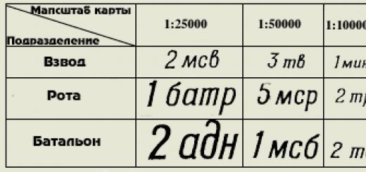
Applied topographic maps:
- 1:25000 - commanders of inputs and companies;
- 1:50000 - battalion commanders;
- 1:100000 - commanders of regiments, divisions, corps;
- 1:200000 - commanders of armies, fronts;
- 1:500000 - overview maps of the fronts, the main command.
The following colors are used for decorating:
- Basic - red, blue, black;
- Auxiliary - brown, green, yellow.
The use of other colors, as well as shades of primary or secondary colors is not allowed.
- RED It is used when designating for our troops the position, tasks, actions, weapons and equipment of motorized rifle, airborne, tank, aviation, and naval units. The same color indicates fire zones, regardless of who created these zones.
- BLUE It is used when designating for enemy troops the position, tasks, actions, weapons and equipment of all types of troops. Also, all inscriptions related to the enemy are applied with this color. The same color indicates flood zones, regardless of who created these zones.
- BLACK used when designating for our troops positions, tasks, actions, weapons and equipment of the missile troops, artillery, anti-aircraft troops, engineering troops, chemical troops, radio engineering troops, signal troops, railway and other special troops. Also, this color is used for all inscriptions related to all branches of our troops.
- BROWN It is used to draw roads, routes, columns of our troops, to fill in the zones of use of bacteriological (biological) weapons, to mark the outer border of the zone of radioactive contamination V.
- GREEN used to mark the outer boundary of the zone of radioactive contamination B.
- YELLOW used to fill the zone of chemical contamination.
All inscriptions are made in straight or oblique standard drawing font. The roman type is used for the title of the map and signatures of officials. In other cases, an oblique font is used (75 degree inclination). Italic capital letters are used for official headings and signatures, as well as at the beginning of a sentence and for abbreviations. Lowercase letters are used to write legends, explanatory inscriptions and a large number of abbreviations. All inscriptions are made only horizontally. Vertical or oblique inscriptions are not allowed.
The size of labels should be proportional to the scale of the map and commensurate with the significance of the subdivision. The table shows the size of the labels depending on the scale of the map and the subdivision (size of the actual size). The font size for designating smaller units, individual objects, explanatory inscriptions cannot be larger than the font size for a platoon.

Drawings of tactical signs of our troops are always directed towards the enemy and vice versa. The exception is anti-aircraft weapons, which are always directed towards the top edge of the map.
If the tactical sign is clearly larger than the actual size of the object on the map scale, then the center of the tactical sign is considered the location of the object on the ground (for flags, the lower part of the flag stem, for arrows, the front end of the arrow).
Control points and means of communication
The command post of the regiment is in place. The inscription KP means - command post, TPU - rear control point. The inscription inside the flag is the number of the regiment.
Battalion command post. The inscription 1/10 MSP means 1 battalion of the 10th motorized rifle regiment.
The same is in motion.
1- Command and observation post of the company commander in place. 2- Infantry fighting vehicle of the company commander (respectively, the armored personnel carrier, the tank of the company commander is designated. A tact mark of this type of equipment and two dashes are put. The platoon commander has one dash.
Observation post of the 10th motorized rifle regiment. If there is a letter inside the sign, then this means that the NP is specialized (A-artillery, I-engineering, X-chemical, B-air surveillance, T-technical). In artillery, special forces, the badge is black.
Traffic control post (R-regulator, checkpoint-checkpoint, KTP-control and technical point.
Communication node. 1- field movable. 2- stationary
Radio. 305 is the brand of the receiver.
Radio station. 1-mobile, 2-wearable. 3- tank
Mobile radio relay station
Radar reconnaissance station. 1- air targets. 2 ground targets.
Radio network of wearable stations.
Radio direction of mobile stations.
March, reconnaissance and protection
1-foot column of troops. Regiment with number designation, battalion with three dashes, company with two dashes, platoon with one dash, squad without dashes.
2. A column of troops on vehicles. There are 2 MSRs on the BMP. if a tank column, then the tank badge, if an armored personnel carrier column, then the armored personnel carrier badge, etc.
1- Column of special troops. Here is the fifth engineer-sapper battalion.
2-Column artillery battalion (battery - two dashes, platoon - one dash, a separate gun on the march - the arrow is shorter and without dashes
The head marching outpost as part of the first motorized rifle company on an infantry fighting vehicle, reinforced by the first platoon of the second tank company (BPZ - side marching outpost, TPZ - rear.
Mobile barrier detachment of the tenth motorized rifle regiment.
Logistics platoon column (VOB), if the company mat. ensure that the inscription - rmob, battalion mob
Column technical closing of the battalion (P-regiment).
Reconnaissance squad.
Patrol squad on BMP
 Combat reconnaissance patrol of the 2nd tank battalion by 0900 on 15 November. (ORD - separate reconnaissance patrol, RD - reconnaissance patrol, OFRD - officer reconnaissance patrol, IRD - engineering reconnaissance patrol, KhRD - chemical reconnaissance patrol), Color of the badge according to the type of troops.
Foot watch.
Foot patrol of the 7th tank company and its patrol route
1 platoon of reconnaissance company of the 10th motorized rifle regiment in search (raid)
1 platoon of the 9th tank company in ambush.
Location and actions of units
The area (area) occupied by the subdivision. There are 3 motorized rifle battalions here. An inscription indicating the unit is mandatory, the tactical sign of the unit's equipment is optional. The sign is large-scale, on the map it covers the entire area occupied by the unit. A dashed line indicates that the area is scheduled to be occupied by that unit. The letter "L" indicates that this is a false area.
The area occupied by a unit whose tactical color is black. Here is the area of the 5th engineer-sapper battalion.
Direction of attack of the unit.
The immediate task of the department. Here 1 is a common sign of a battalion (as indicated by three dashes on the arrow), 2 is a battalion on an infantry fighting vehicle. If a battalion or a company, or a tank platoon, then tank badges, if on an armored personnel carrier, then armored personnel carrier badges, if the battalion is on foot, then sign No. 1 is used. Scale sign!
Follow-up task. Here 1 is the general badge of the battalion, 2 is the badge of the tank battalion. Big sign!
The position (line) reached by the unit by a certain time. Scale sign.
Machine-gun platoon in battle order. Below is the general sign of the battalion and company on the BMP. Scale sign.
The line of a probable meeting with the enemy.
Starting line (regulation line, line for entering second echelon battles, etc. lines
Front (line) occupied by units. Line of contact with the enemy
Deployment line in battalion columns (company - two dashes, platoon - one dash)
Line of transition to the attack. 1-general sign, 2-motorized rifle units.
The line of dismounting motorized rifle units
Firing line of a tank unit. Here is the third firing line of the third tank battalion.
Deployment line of an anti-tank unit
Mining line.
Landing area for tactical airborne troops. Here is the second battalion of the third motorized rifle regiment. disembarkation is expected at 09:00 on 10 July. If the landing has taken place, then the line is solid.
Helicopter landing pad.
Landing area and points for amphibious assault.
The unit was stopped at this turn.
Departure of the unit from the occupied line.
Dividing line between shelves
dividing line between battalions.
Line (position) not occupied by units.
The location of the unit in the defense.
1 - common sign, 2 - motorized rifle unit.
 The place where the prisoner was taken. Here, a soldier of the 2nd Battalion, 26th Infantry Regiment, 19th Mechanized Division was captured at 05:00 on 12 August.
The place of seizure of documents of the murdered.
Weapons of mass destruction and defense against it
Our planned nuclear attack. 015 - target number, 1/5 order - the first battery of the fifth cancer division. -40 - ammunition power 40 kilotons, B - air explosion. "H + 1.10 - the time of the explosion.
Safe removal line (protrusions towards the explosion).
The area of destruction from the explosion of the enemy. The inner ring is a zone of continuous destruction, then - a zone of continuous blockages, weak destruction; the outer ring is the zone of neutron impact on openly positioned personnel.
The area of fire and the direction of the spread of fire.
The location of a nuclear explosion produced by the enemy, indicating the type of explosion, power and time, and the zone of radioactive contamination. The direction and size of the zones are scaled
A point for measuring the level of radiation with an indication of the level. time and date of infection.
Enemy nuclear mine with indication of charge power, depth of laying and detection time.
Field of chemical bombs.
The area contaminated with toxic substances and the direction of displacement of the OM cloud.
Bioweapon site.
Small arms and artillery
light machine gun
easel machine gun
Hand-held anti-tank grenade launcher
Automatic grenade launcher
Anti-aircraft missile wearable complex.
Anti-aircraft gun mount
Mounted anti-tank grenade launcher
Man-portable anti-tank missile systems (ATGMs). Here 1 - ATGM anti-tank-machine gun platoon, 2 - ATGM anti-tank platoon.
Flamethrowers. Here 1-reactive light, 2-reactive heavy.
Antitank gun. 1 - general designation, 2 - up to 85 mm, 3 - up to 100 mm, 4 - more than 100 mm.
A gun. 1 - general designation, 2 - up to 100 mm, 3 - up to 152 mm, 4 - more than 152 mm.
Howitzer. 1 - general designation, 2 - up to 122 mm., 3 - up to 155 mm., 4 - more than 155 mm.
Howitzer with a caliber over 155mm., firing nuclear weapons.
Self-propelled howitzer. Here the caliber is up to 122 mm.
Rocket artillery combat vehicle. 1 is a general designation. 2- medium caliber.
Mortar. 1 - general designation, 2 - small caliber, 3 - medium caliber, 4 - large caliber.
Anti-aircraft gun. 1 is a general designation. 2-small caliber, 3-medium caliber.
Anti-aircraft self-propelled gun. 1 - without radar, 2 - with radar.
Combat vehicle of the anti-aircraft missile system. The inscription of the sign depends on the type of the base machine, the icon inside depends on the type of rocket.
Anti-aircraft missile launcher. 1-short range. 2-short range, 3-medium range. The sign in the circle is the Zen.PU battery.
The area of firing positions of the artillery division. Here is the first division of the 12th artillery regiment. The signs of batteries are off-scale, the area is large-scale.
The firing position of the battery is 100mm. guns.
Firing position of a mortar battery
Separate target. 28 is the number of the target. The blue sign inside the circle is the location of the enemy weapon.
Areas of concentrated fire. The numbers are CO numbers. Scale signs.
A single fixed barrage with its code name.
Deep fixed barrage fire at three lines, indicating the code name So and the numbers of the lines.
A single mobile barrage with indication of its code name and line numbers.
Double mobile barrage
Sequential concentration of fire with indication of the conditional names of the lines and numbers of targets (solid lines - the lines on which it is planned to fire simultaneously; with a double PSO, targets at two lines are connected with solid lines, with a triple one at three. Lines and areas of targets are large-scale.
 Massive fire with indication of its conditional name and section numbers.
A barrage of fire indicating the conditional names of lines, sections for divisions and their numbers, and numbers of intermediate lines.
Firing sector boundary line
The boundary line of the additional sector of fire.
Concentrated fire of a motorized rifle company (SO-1 - section number, 1,2,3 - numbers of platoon sections.
Line of barrage fire of a grenade launcher platoon with indication of its number and sections of squad fires.
Armored vehicles, cars and helicopters
Tank. 1 - general designation, 2 - battalion commander's tank, 3 - amphibious tank, 4 - flamethrower tank
Tank with a complex of anti-tank weapons.
Tank and infantry fighting vehicle with minesweeper
Tank with BTU
Tank with STU
Combat reconnaissance vehicle and combat reconnaissance patrol vehicle (BRDM)
Car and trailer
1-tank tractor, 2-caterpillar tractor, 3-vehicle tractor
Motorbike
ambulance car
Helicopter. 1- general designation, 2-combat, 3-transport.
Engineering equipment and facilities
Tank bridgelayer
Tracked floating conveyor
Caterpillar self-propelled ferry (ferry-bridge vehicle).
Engineering equipment on a wheelbase (Here is a heavy mechanized bridge TMM)
Engineering equipment on a caterpillar base (BAT here).
Pontoon-bridge park with an indication of its type.
Trench of a motorized rifle unit with a covered slot
Trench with communication.
The weapon in the trench. The color of the trench mark according to the type of troops. (same sign for all mobile weapons)
Observation structure of an open type (closed type with a black filled triangle.
Shelter for vehicles (vehicle icon by type)
Shelter indicating the degree of protection and capacity
Open slot
Covered gap
Escarp (counter-scarp) indicating the length.
Inconspicuous wire fence (spiral, net on low posts.
Anti-tank ditch with indication of the length.
Nadolby indicating the type, number of rows and length.
Mined obstruction with an indication of the length.
Wire fence (number of strokes - number of rows).
a section of hedgehog barriers indicating the number of rows and length
anti-tank minefield
Anti-personnel minefield (mixed minefield is indicated by alternating filled and unfilled circles)
Minefields set by means of remote mining.
1 - unguided land mine, 2 - radio-controlled land mine, 3 - land mine, controlled by wire.
Passage in barriers with indication of number and width.
Bridge destroyed by the enemy
A section of the road destroyed by the enemy, indicating the extent of the destruction.
Landing crossing with an indication of the number and type of landing craft.
Crossing tanks under water indicating 3-depth, 180-width of the river, 40-width of the route, P-character of the bottom, 0.8-speed of the current.
Ferry crossing, indicating the number of ferries, their carrying capacity and type of fleet
Ferry crossing of three GSP ferries and 3 ferries of 40 tons each from PMM vehicles.
Bridge on rigid supports. N-low-water 120m long, 4m wide. and a load capacity of 60 tons.
Pontoon bridge 120 m long, with a carrying capacity of 60 tons from the PMP park
The ford is 0.8 m deep, the width of the river is 120 m, the bottom is solid, the speed of the current is 0.5 m/sec.
Ice crossing number five for loads of 60 tons.
Technical support and logistics units and their facilities
Collecting point for damaged cars. P-regimental, 1- its number, bt- for armored vehicles
Repair and evacuation group on an armored personnel carrier. P-regimental, bt - for armored vehicles.
Regimental warehouse. G- fuel, 10tp - tenth tank regiment.
Medical post of the regiment.
Medical center of the battalion.
Company medical post
Rifleman.
Ambulance post
Battalion fueling station
Battalion ammo station
Ammunition point of the company
Service point on the route. G-GSM.
Combined-arms units and divisions
- Motorized Rifle. regiment, battalion, company, platoon, squad - SME, SME, MSR, MSV, MSO
- Tank regiment, battalion, company, platoon tp, tb, tr, tv
- Machine-gun artillery battalion, company poolab, poolar
- Airborne battalion, company, platoon pdb, pdr, pdv
- Air assault battalion, company, platoon dshb, dshr, dshv
- Reconnaissance company, platoon, squad rr, rv, ro
- Machine-gun company, platoon, squad- pull, pull, pull
- Anti-tank platoon ptv
- Grenade launcher squad gv, go
- Anti-tank machine gun platoon ptpulv
Artillery units and divisions
- Artillery regiment, division, battery- up, adn, batr
- Self-propelled artillery battalion, battery- sadn, sabatr
- Battery of anti-tank guided missiles batr ATGM
- Mortar battery, platoon minbatr, minv
- control platoon- woo
Air defense units and divisions
- Anti-aircraft missile battery, platoon, squad - zrbatr, zrv, zro
- Anti-aircraft artillery battery, platoon, squad - zabatr, head, zo
- Anti-aircraft missile and artillery battery- zrabatr
- Battery, platoon of anti-aircraft self-propelled guns - batr ZSU, vzv. ZSU
Special Forces Units
- Engineering and sapper company, platoon, squad- isr, isv, iso
- Engineering assault company, platoon, squad ishr, ishv, isho
- Ferry-landing company- pdesr
- Pontoon company, platoon mon, mon
- Platoon, separation of caterpillar floating conveyors - vzvv. GPT, dep. GPT
- Platoon, department of caterpillar self-propelled ferries - vzvv. GSP, dep. GSP
- Department of Bridgelayers- otd. MTU
- Company, chemical protection platoon - rhz, vhz
- Platoon, department of radiation and chemical reconnaissance - vrhr, orhrr
- Platoon, department of special processing - wso, oso
- Flamethrower platoon, squad- ow, ooh
- Company, platoon, communications department - rs, sun, os
- Commandant's company, platoon kr, kv
Technical Support and Logistics Units
- Separate battalion, material support company- obmo, rmo
- Automobile company, platoon, squad avtr, avtv, auto
- Repair company- remr
- Economic platoon, branch - hozv, hoz
- Supply platoon, supply platoon- vob, sun
- Maintenance department- oto
Control points
- Command post- KP
- Rear control point - TPU
- Command and observation post KNP
- Alternate command post point- ZKP
- Observation post- NP
- Air observation post- PVN
- Artillery observation post ANP
- Point of technical supervision - PTN
- Engineering observation post INP
General terminology
- Vanguard (rearguard) - Av (Ar)
- Bacteriological (biological) weapon- BO
- Bacteriological (biological) infection - BZ
- Battalion filling point - BZP
- Fighting machine- bm
- Infantry fighting vehicle- BMP
- Combat reconnaissance vehicle BRM
- Combat reconnaissance patrol vehicle BRDM
- Lateral marching outpost - BPZ
- Armored personnel carrier armored personnel carrier
- Combat kit- bq.
- Explosives- BB
- Height- high
- Head marching outpost - GPZ
- head watch- DG
- Diesel fuel- DT
- Long-term firing structure (long-term fortification) - DOS (DFS)
- Incendiary weapons (incendiary means) - ZZhO (ZZhS)
- Filling- ban
- Protection against weapons of mass destruction- ZOMP
- Zone of radioactive, chemical, bacteriological (biological) contamination - ZRZ, 3X3, ZBZ
- Anti-aircraft self-propelled installation - ZSU
- Starting line (starting point) - ref. r-zh, (outgoing)
- Kiloton- kt
- Command vehicle - KShM
- Set- set
- Commander of the 1st motorized rifle, 2nd tank battalion - kmsb-1, ktb-2
- Commander of the 1st motorized rifle, 2nd tank company - kmsr-1, ktr-2
- Commander of the 1st motorized rifle, 2nd tank platoon kmsv-1, ktv-2
- Mine-explosive barrier- cost center
- Regiment medical center WFP
- Battalion medical center BCH
- Company medical post MNR
- Emergency ration- NZ
- Irreducible stock- NHS
- firing position- OP
- Outskirts- env.
- Poisonous substances (persistent poisonous substances, unstable poisonous substances) - 0V (OWN, NOW)
- Mark- elev.
- Separate- otd.
- Advance Squad- BY
- Mobile detachment of barriers - POS
- Field filling point - PZP
- Consistent concentration of fire- PSO
- Enemy- pr-to
- Air defense (anti-tank defense) - Air defense (PTO)
- Anti-personnel minefield- PPMP
- Anti-tank minefield- PTMP
- Antitank reserve- PTres.
- radioactive contamination- RZ
- Radioactive substances- RV
- Radiation and chemical reconnaissance- RHR
- Reconnaissance Squad- RO
- dividing line- boundary line
- Radio network (radio direction) - r/s (r/n)
- Area- district
- Repair and evacuation group (repair group) - REG (Rem. G)
- Limit of regulation (regulation point) - rr per. (p. per.)
- Collecting point for damaged cars - SMTA
- Guard detachment (outpost, outpost) - St.O (St.Z, St.P)
- North, south, east, west north, south, east, west
- northwest, northeast, west, southeast southwest northwest, northeast, southeast, southwest
- Focused fire - SO
- Daily dacha- s/d
- Tactical airborne Tact. VD
- Tank bridge layer MTU
- Rear outpost - TPZ
- Communication node- mustache
- Fortified area- UR
- Chemical observation post HNP
- Chemical contamination - HZ
- Chemical weapon- XO
- Chemical mine- HF
- Nuclear weapon- nuclear weapons
- nuclear mine-
- NM Nuclear-mine barrier- YaMZ
Selected local items
Plants, factories and mills with chimneys, expressed (1) or not expressed (2) at the scale of the map |
||
Tower-type capital structures |
Light towers |
power plants |
Transformer booths |
Points of the state geodetic network |
Aerodromes and hydroaerodromes |
Water mills and sawmills |
Windmills |
wind turbines |
 Plants, factories and mills without chimneys: 1) expressed on a map scale; 2) not expressed in the scale of the map. |
Radio stations and television centers |
Radio and television masts |
Fuel depots and gas tanks |
Separate trees that have the value of landmarks: 1) coniferous; 2) deciduous |
 Individual groves of significant landmarks |
Narrow strips of forest and protective afforestation |
Narrow strips of shrubs and hedges |
Individual bushes |
Communication lines |
 Mounds, height in meters |
Rocks-outliers |
Power lines on metal or reinforced concrete poles |
 Pits, depth in meters |
Clusters of stones |
Power lines on wooden poles |
Weather stations |
Separately lying stones, height in meters |
Ground oil pipelines and pumping stations |
 Open pit mining sites |
Peat mining |
Underground oil pipelines |
Churches |
Monuments, monuments, mass graves |
Stone, brick walls |
Dams and artificial ramparts |
Foresters' houses |
Roads
 Three-track railways, semaphores and traffic lights, turntables |
Highway: 5 is the width of the covered part, 8 is the width of the entire road from ditch to ditch in meters, B is the coating material |
 Double track railways and stations |
 Improved dirt roads (8-way width in meters) |
 Single track railways, sidings, platforms and stopping points |
dirt roads |
 Electrified railways: 1) three-track; 2) double-track; 3) single track |
Field and forest roads |
Narrow gauge railways and stations on them |
hiking trails |
 Freeways, embankments |
 Fashinny sections of roads, gati and rowing |
 Improved highways, cuts |
 Crossings: 1) under the railway; 2) over the railway; 3) on the same level |
Hydrography
 Small rivers and streams |
 The banks are steep: 1) without a beach; 2) with a beach that does not end at the scale of the map |
 Canals and ditches |
 Lakes: 1) fresh; 2) salty; 3) bitter-salty |
 Wooden bridges Bridges metal Bridges made of stone and reinforced concrete |
 Bridge characteristics: K-material of the building (K-stone, M-metal, reinforced concrete concrete, D-wooden); 8-height above water level (on navigable rivers); 370 - bridge length, 10 is the width of the carriageway in meters; 60-capacity per ton |
 Water level marks Arrows showing the direction of the flow of rivers (0.2 is the speed of the flow in m / s.) |
 Characteristics of rivers and canals: 170-width, 1.7-depth in meters, P-character of the bottom soil piers Brody: 1.2-depth, 180-length in meters, T-character of the soil, 0.5-flow rate in m / s. |
 Dams: K-material of the structure, 250-length, 8-width of the dam along the top in meters; in the numerator - the mark of the upper water level, in the denominator - the lower |
 Gateways Ferries: 195-river width, 4x3-ferry dimensions in meters, 8-capacity in meters |
Surface water pipelines |
Wells |
Underground water pipelines |
Sources (keys, springs) |
The system of basic conventional signs used in graphic documents of peacetime and wartime tactical level Part 4 "Motorized Rifle Battalion" -
The procedure for the formation of a combat graphic document. Fire card of a motorized rifle squad when planning offensive operations. Conditions of the situation: COMBAT ACTIVITIES. Type of hostilities - OFFENSIVE -
SYMBOLS FOR TOPOGRAPHIC PLANS -
In general, when hunting, a certain tactic is also needed, similar to the one that will be described in this article. And for hunting you do not need to buy firearms, just take A pistol-type rifles and start hunting. In general, it is more convenient and pleasant. Also, this kind of crossbow can be used for ordinary sports purposes - target shooting.
A topographic map is a graphic representation of an area. This document contains accurate information about the terrain, objects and objects located on it. A topographic map is a reduced in size, universal image of the earth's surface.
Classification of topographic maps
Topographic maps are divided into different types according to the following criteria: scale, special content of information, purpose of use. Various maps of the area are also classified according to scientific areas.
Types of topographic maps:
- Geographic.
- Topographic.
- Geological.
- Historical.
- Political.
- Soil.
Topographic map scales
When compiling maps of the area, depending on the tasks, it is necessary to use different scales. Scale is the mathematical relationship between the length of the segment between certain points shown on the map and the actual distance between these points located on a particular area.
With the help of scales, you can determine the multiplicity of the reduction in the length on the plan in relation to the corresponding size on the ground. For example, a scale of 1: 10,000 indicates that all distances between points on the ground are reduced by a map of 10,000 times. Or 1 cm on the map is equal to 100 meters on the ground.

The number in the denominator affects the amount of zoom out. Smaller scale (small scale map) has more value in the denominator. For example, survey-topographic small-scale maps have values such as 1: 1,000,000 or 1: 500,000, etc. Large-scale documents contain more detailed information about the area depicted. More details can be seen here.
Data on the numerical value of the scale is located at the very bottom of the image (beyond the southern frame of the document). The entry is in the form of a fraction. The numerator is always one. The denominator indicates the number of times the image has been reduced.
The scale value is how many real kilometers physically fit in one centimeter on the plan.
Conditional topographic designations
Objects and objects located on the ground are depicted on a topographic document in the form of conventional signs. For a competent reading of the information depicted, it is necessary to familiarize yourself and study the basic alphabet of the document - its conventional signs. Without this, it is impossible to study the area according to the topographic drawing.
Conventional topographic signs are divided into the following categories:
- large-scale conditional topographical signs;
- off-scale symbols;
- explanatory.

With the help of scale symbols, a description and image of local objects and objects is given, which can be shown on the drawing in the form of occupied areas and outlines on the scale of a plan or map. This is how rivers, lakes, swamps, mountains, forests, large buildings, bridges, railways and roads, settlements are designated.
Off-scale conventional signs denote objects that occupy small areas; they cannot be depicted on a scale: wells, radio masts, factory pipes, poles, individual buildings, etc.
With the help of explanatory topographic signs, additional information is given that characterizes the features of objects or objects located in a given area in combination with large-scale and off-scale signs: the direction of the flow of rivers, an indication of the type of forest plantations, etc.
In addition to graphic signs, topography uses various inscriptions for explanation, the purpose and purpose of the object is specified, for example, shk. - school. Numerical values and proper names are also used to indicate specific settlements, rivers, roads, characteristics of their parameters (width, height, etc.).
For each locality, there is a specific system of conventional signs, with their help they designate: relief, hydrography, a network of roads and road junctions, local objects, boundaries, features of soil and vegetation cover. Conventional signs help to create a visual representation of the actual state of the area under study.
The purpose of topographic maps is to present a section of a particular area in a three-dimensional three-dimensional image. With the help of the so-called contour lines, the terrain is depicted. These are lines connecting equal heights above sea level. The reference point is the zero of the Kronstadt water-measuring station - the average level of the Baltic Sea.
If a separate relief cannot be shown using horizontal lines, they are depicted in the form of special conventional signs: cliffs, gullies, pits, mounds, ravines, rocks, etc.
Distance measurements on the map
Measurements on the map are made using a measuring compass. The needles of the compass are applied to the end points of the segments on the plan. And then the resulting compass solution is deposited on a regular ruler, where the length of each segment is determined. If the lines are larger than the linear scale, the measurement is made in several steps.
The distances between points in the drawing along curved lines are measured step by step using small compass solutions. On average, the step length is 0.5 - 1.0 cm.
Long winding lines are measured with a special device called a curvimeter. It consists of a wheel and an arrow combined with a dial. The wheel moves along a specific line on the plan, the arrow indicates the distance traveled. The division price on the scale of the dial is equal to one kilometer or centimeter. The resulting readings in cm are multiplied by the scale of this plan.
Before the start of the journey, the arrow is set to zero. If, when rolling the wheel, the readings of the device decrease, it is necessary to turn the curvimeter by 180 °.
If you do not have a ruler with divisions or a curvimeter at hand, you can use a strip of paper or graph paper.
Orientation with a map
When orienting on the map, the standing point and comparison of the map with the surrounding area are first determined. The document is placed in such a position that its directions coincide with a specific area. In this case, the south is below, the north is above, the east and west are respectively on the right and left. Orientation of the map is carried out approximately by eye or with the help of a special line of sight or a compass.
Determination of the standing point
To determine the standing point, landmarks are used according to the following criteria:
- Local items.
- Characteristic details and landforms.
- The notches left when passing distances.
The standing point is determined by near landmarks after the map is oriented to the cardinal points and identified on the ground, as well as on the plan of nearby objects or relief elements. Taking into account the scale and approximate distance to the identified objects, a standing point is marked on the document.


Topographic symbols- these are symbolic symbols of terrain objects used to depict them on topographic maps and plans. Topographic conventional signs convey the appearance, location and some qualitative and quantitative characteristics of objects, contours and relief elements reproduced on maps and plans.
Types of topographic symbols
The area on maps and plans is depicted by topographic symbols. All conventional signs of local objects according to their properties and purpose can be divided into the following three groups: contour, scale, explanatory.
Contour symbols
Contour cartographic symbols are used to designate local objects that are expressed on the scale of a topographic map, for example, forests, gardens, swamps, etc. The contours (boundaries) of such objects are depicted on a map or plan by figures similar to their actual outlines in nature. They are usually drawn with a dotted line, if they do not coincide with other lines marked on the ground (for example, ditches, fences, etc.).
The area inside the contours is filled with monotonous icons established for each local object - contour conventional signs. By itself, a contour symbol does not indicate on a topographic map or plan either the location of an individual object within the contour (for example, a tree in a forest), or its linear dimensions (for example, the height or thickness of a tree).
Scale symbols
TO large-scale cartographic symbols include images of smaller objects that cannot be expressed to scale. They are called large-scale because their number and size depend on the scale of the topographic map or plan: the smaller the scale, the fewer such signs and they themselves are smaller.
Some local objects are depicted with such conventional signs on topographic maps of all scales, for example, wells, kilometer posts, individual trees, etc. Others, depending on the scale of the map, can change the type of their sign. For example, settlements on a large scale are depicted by contour symbols with almost all of their details. As the map is zoomed out, the same points are shown in less detail and more generally; on topographic maps of small scales, they can be depicted only by small circles, that is, by large-scale conventional signs.
Unlike contour symbols, large-scale conventional signs always indicate the exact location of the objects they designate, while the position of wells, water mills, oil wells, mounds, geodesic signs and other objects depicted on maps by circles, squares, asterisks and other symmetrical figures are determined by the centers of the latter. .
The places of standing of kilometer posts, road signs, individual trees, etc., are the top of the right angle formed by the vertical line of the sign and its base (cutting). The location of telephone and meteorological stations, elevators, yurts, etc. is determined by the middle of the base of the sign. Finally, the position of roads, ditches and other elongated objects depicted on a topographic map or plan by one or more lines is determined by the axis (middle) of the sign.
Thus, with accurate measurements on the map, the distances between objects depicted by scale marks should be determined using the above points and lines that determine the actual position of the points and the lines that determine the actual position of the points on the ground.
Large-scale cartographic symbols by themselves do not indicate the size of objects, so it is impossible, for example, to measure the width of a road or the size of a silo on a map.
Explanatory symbols
TO explanatory cartographic symbols includes all other symbols on a topographic map or plan that are used to additionally characterize local objects. They are always used in combination with conventional topographical signs of the first two types. For example, when marking a forest on a map, inside the contour, in addition to the contour signs of the forest (circles), an explanatory sign is placed in the form of a deciduous or coniferous tree indicating the species and age of the trees; when depicting some types of roads, they are indicated by strokes perpendicular to the axis of the road, slopes steeper than 10 degrees on rivers, the direction of the flow is indicated by an arrow, etc.
The explanatory topographic symbols also include various signatures and numbers accompanying some conventional signs.
Signatures are used to indicate their own names of objects, such as settlements, rivers, etc., as well as for a more detailed description of local objects depicted on maps. For this, for example, next to the topographic symbols of industrial and agricultural enterprises, mining developments and some other items, the type of production, extraction or other characteristic is abbreviated. For example, kirp. - brick factory, grain. - grain state farm, angry. - gold mines, dry. - dry well
In the same way, abbreviated captions explain some local objects and landmarks that do not have their own cartographic symbols, but stand out in their meaning. For example, a patient's signature is put at the hospital building, B. at the railway booth, etc. The list of abbreviated signatures used on maps is given below.
Numerical designations are used to indicate the number of households in rural settlements, the heights of the most characteristic points of the relief, the low water level (the most stable water level during the summer) of water in rivers or lakes, etc.
Conventional signs maps of scales 1:25,000, 1:50,000 and 1:100,000 are basically the same in outline and differ only in their sizes.
Conventional signs and designations for some old maps and plans
| Interpretation of conventional topographic signs and designations used on maps from the atlas of the Russian Empire of 1745: “The Russian Atlas, consisting of nineteen special maps representing the All-Russian Empire with border lands ...” | |
| Conventional signs and designations used on general survey plans | |
 |
Explanation of conventional topographic signs and designations used on maps from the atlas of the Russian Empire of the early 19th century: "Geographical Atlas of the Russian Empire, the Kingdom of Poland and the Grand Duchy of Finland, located in the provinces ..." |
 |
Conventional topographic signs and designations for one-verst military topographic maps |
| Conditional topographic signs and designations used on the Special Map of the Western Part of the Russian Empire (Schubert Map) | |
 |
Conditional topographic signs and designations used in the Special Map of European Russia with the adjoining part of Western Europe and Asia Minor (Strelbitsky's map) |
 |
Conditional topographic designations and signs used in the Detailed Military Map along the Russian-Prussian Border, 1799 |
 |
Explanations of topographic signs and designations used on maps from the atlas of 1910: "Marx's Large World Desktop Atlas" |
| Conventional topographic designations and signs used on the map of Asiatic Russia, 1901 |
Declassified topographic maps of the General Staff of the USSR freely roam the Internet. We all love to download them, view them, and often print them on sheets of paper for further use for their intended purpose - i.e. go hiking with them.
Topographic maps of the General Staff are the most accurate and best. Any other purchased cards printed in modern times will not carry so much accuracy and specificity. Symbols and designations on the topographic maps of the General Staff are much more complex than any other designations of maps bought in the store. We all remember them from geography lessons at school.
As an experienced user of such maps, I would like to describe at the beginning of this article the most important, in my opinion, designations. If the rest are more or less understandable, since they are almost all identical with other types of maps (not the General Staff), then these are something new and still incomprehensible. Actually, I will start with the symbols of rivers, fords, forests and roads.
Rivers and water resources
| River speed and direction (0.6 m/s) | |
|
Characteristics of rivers and canals: 30 - Width (m), 0,8 - Depth (m), TO- Soil type ( TO - rocky P - sand, T - solid, IN - viscous) |
 |
| Water level mark, coast height above sea level (393m) |  |
| Brody: 0,3 - depth, 10 - length, TO- rocky ground 1,0 - speed (m/s) |  |
| swamp passable |  |
| swamp impassable |  |
| Bridge characteristics: D- building material D - wood, TO - stone, JB - reinforced concrete) 43 - the length of the bridge, 4 - width of the carriageway (m), 10 - carrying capacity in tons |  |
| Forest clearing and width in meters (2m) |  |
| Field and forest roads |  |
| Zimnik, operating road only in the winter season, during the cold period. Can pass through swamps. |  |
| Dirt road, 6 - width of the carriageway in meters |  |
| Gat - a road with a wooden surface, a flooring made of logs, 3 - roadway width |  |
| gat |  |
| Railway canvas |  |
| gas pipeline |  |
| Power lines (TL) |  |
| Dismantled railroad |  |
| Single track, narrow gauge railway. Also railway bridge |  |
| Highway: 6 — the width of the covered part, 8 - the width of the entire road from ditch to ditch in meters; SCH- coating material ( B - cobblestone, G - gravel, TO - crushed stone Shl - slag SCH - crushed stone) |  |
Relief
| Steep banks of rivers, rocky outcrops, parmas |  |
| Relief contours with relative height designation (260 m) |  |
| Mountainous area without vegetation cover, covered with kurum stones and remnant rocks |  |
| Mountainous area with vegetative cover and sparse trees, forest border visible |  |
| Rocks-outliers with a height in meters |  |
| Glaciers |  |
| Rocks and cliffs |  |
| Elevation mark (479.2 m) |  |
| Steppe region. near the edge of the forest |  |
| Sands, deserts |  |
Photo of some geographical objects


The main winter road, laid through the taiga forest. Thickets here in summer (Yakutia)

Forest dirt road (Ivdelsky district, Northern Urals)

Gat - a road with a wooden surface (Lobnensky forest park, Moscow region)

Rock outcrop, parma (Stone "Giant", Middle Urals)

Rocks-outliers (rock Old Man-Stone, Middle Urals)
It should be understood that all available topographic maps of the USSR General Staff have long been outdated. The information contained on them can date back to the 70-80s of the last century. If you are interested in the details of passing along certain trails, roads, the presence of settlements and geographical objects, then you should check the accuracy of information from other sources in advance. Paths and roads may no longer exist at all. Small settlements can be abandoned and represent wastelands, often already overgrown with young growth.
But, in any case, the maps of the General Staff still carry more accurate information, and you can more productively calculate your route and distance from them. In this article, I did not fill your heads with unnecessary symbols and conventional signs of topographic maps. I posted only the most important and significant for the mountain-taiga and steppe region. Those who are interested in the details can look.
Maps of the General Staff of the USSR were made using the Soviet system of layout and nomenclature of topographic maps. This system is still used in the Russian Federation and in some former Soviet republics. There are newer maps, the state of the terrain on which is approximately 60-80s of the last century, and older maps, the so-called General Staff of the Red Army, made by pre-war geodetic intelligence. "The maps are compiled in the Gauss-Kruger conformal transverse-cylindrical projection, calculated from the parameters of the Krasovsky ellipsoid for the six-degree zone," - And if you don't understand, don't worry! The main thing is to remember (or write down, save this article) those points that I cited above. Knowing them, you can skillfully use maps and plan your route without using gps.

Geography. Modern illustrated encyclopedia. - M.: Rosman. Under the editorship of prof. A. P. Gorkina. 2006 .
See what "conventional signs" are in other dictionaries:
Symbolic, dashed and background designations of terrain objects, combat and meteorological conditions used on topographic and other geographical maps, as well as on graphic documents. Depending on the purpose, they distinguish ... ... Marine Dictionary
Conventional signs- Signs... Geographic atlas
Graphic, alphabetic and digital designations of objects and elements of the terrain, operational tactical and meteorological conditions used on topographic and other geographical maps, as well as on graphic documents. Depending on the… … Emergencies Dictionary
Conventional signs- graphic symbols and standard abbreviations of explanatory inscriptions to them, used in military operational documents, on diagrams, maps, report cards, etc. to indicate the position of troops, rear units (units) ... ... Brief dictionary of operational-tactical and general military terms
conventional signs- sutartiniai ženklai statusas T sritis Gynyba apibrėžtis Vietovės objektų, kovinės ir meteorologinės situacijos žymėjimo žemėlapiuose ir kt. koviniuose grafiniuose dokumentuose ženklai. Pagal paskirtį jie būna taktiniai, topografiniai ir… … Artilerijos terminų žodynas
conventional signs- sutartiniai ženklai statusas T sritis ekologija ir aplinkotyra apibrėžtis Grafiniai simboliai, kuriais žemėlapiuose reiškiamas jų turinys. Simboliais vaizduojami fiziniai Žemės paviršiaus objektai (jų padėtis, kiekybiniai ir kokybiniai… … Ekologijos terminų aiskinamasis žodynas
Conventional signs- signs used in the preparation of plans and diagrams of the scene and other places of investigative actions. They are a set of standard topographic signs and designations of objects found in the investigative ... ... Forensic Encyclopedia
Conventional signs- symbolic line and background designations of terrain objects, combat and meteorological conditions used on geographical maps and graphic documents. Topographic, tactical, and meteorological U. z. They can… … Dictionary of military terms
SYMBOLS- GENERAL INFORMATION ABOUT THE continent Name of the mainland Area in thousand square meters. km Coordinates of extreme points The highest height above sea level The lowest height above sea level Eurasia 54 870 north. metro Chelyuskin 77º43′ N 104º18′ E south m. ... ... Geographic atlas
Cartographic conventional signs are a system of symbolic graphic designations used to depict various objects and phenomena on maps, their qualitative and quantitative characteristics. Conventional signs used on the map ... ... Wikipedia
Books
- , . Conventional signs for topographic plans. Scales 1: 5000, 1: 2000, 1: 1000 and 1: 500 Reproduced in the original author's spelling of the 1973 edition (Nedra Publishing House). ...
- Symbols for topographic plans , . Conventional signs for topographic plans. Scales 1: 5000, 1: 2000, 1: 1000 and 1: 500 Reproduced in the original author's spelling of the 1973 edition (Nedra publishing house ...