The territory of Russia, in comparison with other states located in seismically active regions, is generally characterized by moderate seismicity. But in our country there are also places where there is strong shaking, and therefore it can be extremely dangerous to live.
Kuril Islands and Sakhalin
The Kuril Islands and Sakhalin are part of the volcanic Belt of Fire of the Pacific Ocean. In fact, the Kuril Islands are the tops of volcanoes rising above the surface of the ocean, and volcanoes played an important role in the formation of Sakhalin. Every day, seismic stations record tremors in this area.
On the night of May 28, 1995, the largest earthquake in Russia in the last hundred years occurred on Sakhalin. Neftegorsk was completely destroyed. Despite the fact that the intensity of the tremors barely exceeded 7 points on a 12-point scale, large-block earthquake-resistant houses collapsed. 2040 people were killed, more than 700 were injured. The real tragedy was that on this day the high school students had their graduation. The building where the school ball was held collapsed, burying the graduates.
As always during earthquakes, rescuers recorded miraculous rescues. For example, one man fell into the basement of a house, where he was able to eat leftover pickles for many days and survived.
Kamchatka
The peninsula is also part of the Pacific volcanic belt. There are 29 active volcanoes and dozens of “dormant” ones in Kamchatka. Small tremors associated with tectonic processes and volcanic activity are recorded every day. Fortunately, most earthquakes occur at sea and in sparsely populated areas.
An earthquake with a magnitude of 8.5 that occurred on November 4, 1952 in Avacha Bay was included in the 15 most powerful earthquakes of the 20th century and was called the “Great Kamchatka”. It caused a tsunami that washed away Severo-Kurilsk and reached Japan, Alaska, Hawaii and even Chile.
After this, a network of seismic stations was created in the Far East.
North Caucasus and Black Sea coast
For the danger of this region, residents should “thank” the Arabian Plate, which collides with the Eurasian Plate. Seismologists have a complex name for the region: Crimea-Caucasus-Kopet Dag zone Iran-Caucasus-Anatolian seismically active region. Earthquakes of magnitude 9 and higher often occur here. On the Russian side, the territories of Dagestan, Chechnya, Ingushetia and North Ossetia are considered dangerous.
The largest events are called the nine-magnitude earthquake in Chechnya in 1976 and the Chkhalta earthquake in 1963. Everyone who was born in the USSR remembers the Armenian Spitak, in which 25 thousand people died.
The Stavropol region is also uneasy. Tremors are felt in the cities of Anapa, Novorossiysk and Sochi. The great Crimean earthquake of 1927 is described in the famous novel “The Twelve Chairs”.
Lake Baikal is located in the middle of a huge rift zone - a fault in the earth's crust. Up to 5-6 thousand tremors are recorded here per year. On the rift line going into Mongolia, there is also its own “valley of dormant volcanoes” on the Oka Plateau in Buryatia.
The most famous earthquake on Lake Baikal, the Tsagan earthquake, occurred on January 12, 1863. Then, on the southeastern shore of Baikal, an entire valley went under water, and Proval Bay was formed.
The last strong earthquake occurred on August 27, 2008. The epicenter was located in the southern waters of Lake Baikal, the strength was 10. In Irkutsk there were 6-7 points. People panicked, ran out into the street, and cellular communications collapsed. In Baikalsk, where the temperature reached 9 points, the work of the pulp and paper mill was interrupted.
Fortunately, most strong earthquakes in this region do not cause casualties, since the area is sparsely populated and multi-story buildings are designed to withstand tremors.
Altai and Tyva
In both Altai and Tuva, complex processes lead to earthquakes. On the one hand, the region is influenced by the huge Hindustan plate, due to the movement of which to the north the Himalayas were formed, and on the other hand, by the Baikal Fault. Seismic activity in the region is increasing.
A 10-magnitude earthquake that occurred on September 27, 2003 caused a lot of noise in Altai. It reached Novosibirsk, Kuzbass and Krasnoyarsk. Six districts of the republic were damaged, the village of Beltir was destroyed, 110 families were left homeless. Buildings in the villages of Kosh-Agach and Aktash were destroyed.
In Tuva, the local population was frightened by the earthquake that occurred on the evening of December 27, 2011. In the villages of the republic, houses cracked and collapsed. Chandeliers swayed in the homes of residents of Abakan and Novokuznetsk. What added to the fear was that it was bitterly cold outside. Seismic activity continued almost throughout the winter. So, in February 2012, seismologists counted more than 700 tremors.
In the vast area of Yakutia, there are two seismic zones. The northern one goes from the Lena delta to the Sea of Okhotsk along the Chersky ridge, the southern one - Baikal-Stanovoi - stretches from Lake Baikal to the Sea of Okhotsk. Every day there are two or three tremors here. The strongest earthquake is called the nine-magnitude Oymyakon earthquake of 1971. The tremors were felt over an area of one million square kilometers and reached Magadan. And in April 1989, between the valleys of the Lena and Amur rivers, an 8.0 magnitude earthquake occurred over an area of one and a half million square kilometers! The Yakuts themselves claim that the republic accounts for almost a third of all seismic activity in Russia.
Over 300 years, 42 earthquakes with magnitudes ranging from 3 to 6.5 were recorded in the Urals.
Recent studies indicate that tremors of up to 7 magnitude are possible here. True, this happens once every 110-120 years. Now there is an increase in seismic activity.
The last strong earthquake occurred on March 30, 2010, near Kachkanar. At the epicenter, the force of the tremors was 5 points. Windows in houses shook, car alarms went off.
Of course, for those who live in the central regions, what is happening on the outskirts of Russia will seem distant, but it turns out that there are events that affect the entire country. So, on May 24, 2013, at the bottom of the Sea of Okhotsk, at a depth of 620 kilometers, an 8.0 magnitude shock occurred. The earthquake was unique: it swept across the entire country, becoming the fourth in Western Russia over the past 76 years.
This earthquake brought a lot of thrills to the inhabitants of the capital's skyscrapers. Some offices evacuated workers.
One scientist figuratively said about seismicity that “our entire civilization is being built and developed on the lid of a cauldron, inside of which terrible, unbridled tectonic elements are boiling, and no one is safe from the fact that at least once in their life they will not find themselves on this bouncing lid.”
These “funny” words interpret the problem quite loosely. There is a strict science called seismology (“seismos” in Greek means “earthquake”, and this term was coined about 120 years ago by the Irish engineer Robert Male), according to which the causes of earthquakes can be divided into three groups:
· Karst phenomena. This is the dissolution of carbonates contained in the soil, the formation of cavities that can collapse. Earthquakes caused by this phenomenon are usually of low magnitude.
· Volcanic activity. An example is the earthquake caused by the eruption of the Krakatoa volcano in the strait between the islands of Java and Sumatra in Indonesia in 1883. Ash rose 80 km into the air, over 18 km 3 fell, and this caused bright dawns for several years. The eruption and sea wave over 20 m high led to the death of tens of thousands of people on neighboring islands. However, earthquakes caused by volcanic activity are observed relatively rarely.
· Tectonic processes. It is because of them that most earthquakes occur on the globe.
“Tektonikos” translated from Greek means “build, builder, structure.” Tectonics is the science of the structure of the earth’s crust, an independent branch of geology.
There is a geological hypothesis of fixism, based on the idea of the inviolability (fixedness) of the positions of the continents on the Earth's surface and the decisive role of vertically directed tectonic movements in the development of the earth's crust.
Fixism is opposed to mobilism, a geological hypothesis first expressed by the German geophysicist Alfred Wegener in 1912 and suggesting large (up to several thousand km) horizontal movements of large lithospheric plates. Observations from space allow us to speak about the unconditional correctness of this hypothesis.
The Earth's crust is the upper shell of the Earth. There is a distinction between continental crust (thickness from 35...45 km under the plains, up to 70 km in the mountains) and oceanic (5...10 km). The structure of the first has three layers: upper sedimentary, middle, conventionally called “granite,” and lower “basalt”; in the oceanic crust there is no “granite” layer, and the sedimentary layer has a reduced thickness. In the transition zone from the continent to the ocean, an intermediate type of crust (subcontinental or suboceanic) develops. Between the Earth's crust and the Earth's core (from the surface of Mohorovicic to a depth of 2900 km) is the Earth's mantle, which makes up 83% of the Earth's volume. It is believed that it is mainly composed of olivine; Due to the high pressure, the mantle material appears to be in a solid crystalline state, with the exception of the asthenosphere, where it is possibly amorphous. The temperature of the mantle is 2000...2500 o C. The lithosphere includes the earth's crust and the upper part of the mantle.
The interface between the Earth's crust and the Earth's mantle was identified by the Yugoslav seismologist A. Mohorovicic in 1909. The speed of longitudinal seismic waves when passing through this surface increases abruptly from 6.7...7.6 to 7.9...8.2 km/s.
According to the theory of “planar tectonics” (or “plate tectonics”) by Canadian scientists Forte and Mitrovica, the earth’s crust throughout the entire thickness and even slightly below the Mohorovicic surface is divided by cracks into plane-platforms (tectonic lithospheric plates), which carry the load of oceans and continents . 11 large plates have been identified (African, Indian, North American, South American, Antarctic, Eurasian, Pacific, Caribbean, Cocos plate west of Mexico, Nazca plate west of South America, Arabian) and many small ones. The slabs have different heights. The seams between them (the so-called seismic faults) are filled with a material that is much less durable than the material of the slabs. The plates seem to float in the earth's mantle and continuously collide with one another at their edges. There is a schematic map that shows the directions of movement of tectonic plates (relatively relative to the African plate).
According to N. Calder, there are three types of joints between slabs:
A crevice formed when plates move away from each other (North American from Eurasian). This results in an annual increase of 1 cm in the distance between New York and London;
A trench is an oceanic depression along the boundary of plates as they approach each other, when one of them bends and plunges under the edge of the other. This happened on December 26, 2004, west of the island of Sumatra during the collision of the Indian and Eurasian plates;
Transform fault - sliding of plates relative to each other (Pacific relative to North American). Americans sadly joke that San Francisco and Los Angeles will sooner or later unite, since they are on different sides of the Saint Andreas seismic fault (San Francisco is on the North American plate, and the narrow Californian section, together with Los Angeles, is on Pacific) about 900 km long and move towards each other at a speed of 5 cm/year. When an earthquake occurred here in 1906, 350 km of the indicated 900 shifted and froze with a displacement of up to 7 m. There is a photograph that shows how one part of a California farmer’s fence shifted along the fault line relative to the other. According to the predictions of some seismologists, as a result of a catastrophic earthquake, the California Peninsula could be torn away from the mainland along the Gulf of California and turn into an island or even sink to the bottom of the ocean.
Most seismologists attribute the occurrence of earthquakes to the sudden release of elastic deformation energy (elastic release theory). According to this theory, long-term and very slow deformations - tectonic movement - occur in the fault area. This leads to the accumulation of stress in the slab material. The stresses grow and grow and at a certain point in time reach the limiting value for the strength of rocks. Rock rupture occurs. The rupture causes a sudden rapid displacement of the plates - a push, elastic recoil, resulting in seismic waves. Thus, long-term and very slow tectonic movements transform into seismic movements during an earthquake. They have high speed due to the rapid (within 10...15 s) “discharge” of the accumulated enormous energy. The maximum earthquake energy recorded on Earth is 10 18 J.
Tectonic movements occur along a significant length of the plate junction. The rupture of rocks and the seismic movements caused by it occur at some local section of the junction. This area can be located at different depths from the Earth's surface. This area is called the source or hypocentral region of the earthquake, and the point in this region where the rupture began is called the hypocenter or focus.
Sometimes not all the accumulated energy is “discharged” at once. The unreleased part of the energy causes stress in new bonds, which after some time reaches the limiting value for the strength of rocks in certain areas, as a result of which an aftershock occurs - a new rupture and a new shock, but of less force than at the time of the main earthquake.
Earthquakes are preceded by weaker tremors - foreshocks. Their appearance is associated with the achievement in the massif of such stress levels at which local destruction occurs (in the weakest areas of the rock), but the main crack cannot yet form.
If the source of the earthquake is located at a depth of up to 70 km, then such an earthquake is called normal; at a depth of more than 300 km, it is called deep-focus. At intermediate focal depths, earthquakes are called intermediate. Deep-focus earthquakes are rare; they occur in the area of ocean basins, are distinguished by a large amount of released energy and, therefore, have the greatest effect on the Earth's surface.
The effect of earthquakes on the Earth's surface, and consequently their destructive effect, depend not only on the amount of energy released during a sudden rupture of material at the source, but also on the hypocentral distance. It is defined as the hypotenuse of a right triangle, the legs of which are the epicentral distance (the distance from the point on the Earth’s surface where the intensity of the earthquake is determined to the epicenter - the projection of the hypocenter onto the Earth’s surface) and the depth of the hypocenter.
If you find points on the Earth's surface around the epicenter where an earthquake occurs with the same intensity, and connect them with lines, you will get closed curves - isoseites. Near the epicenter, the shape of the isoseites to a certain extent repeats the shape of the source. As you move away from the epicenter, the intensity of the effect weakens, and the pattern of this weakening depends on the energy of the earthquake, the characteristics of the source and the medium of passage of seismic waves.
During earthquakes, the Earth's surface experiences vertical and horizontal vibrations. Vertical fluctuations are very significant in the epicentral zone, but already at a relatively short distance from the epicenter their significance quickly decreases, and here we mainly have to take into account horizontal influences. Since cases of the epicenter being located within or near settlements are rare, until recently only horizontal vibrations were mainly taken into account in design. As the building density increases, the danger of locating epicenters within populated areas increases accordingly, and therefore vertical fluctuations also have to be taken into account.
Depending on the effect of an earthquake on the Earth's surface, they are classified according to intensity in points, which is determined on various scales. In total, about 50 such scales were proposed. Among the first are the Rossi-Forel (1883) and Mercalli-Cancani-Sieberg (1917) scales. The latter scale is still used in some European countries. In the USA, since 1931, a modified 12-point Mercalli scale (MM for short) has been used. The Japanese have their own 7-point scale.
Everyone is familiar with the Richter scale. But it has nothing to do with classification by intensity points. It was proposed in 1935 by the American seismologist Charles Richter and theoretically substantiated together with B. Gutenberg. This is a magnitude scale - a conditional characteristic of the deformation energy released by the earthquake source. Magnitude is found using the formula
where is the maximum displacement amplitude in the seismic wave, measured during the earthquake under consideration at some distance (km) from the epicenter, μm (10 -6 m);
The maximum displacement amplitude in a seismic wave, measured during some very weak (“zero” earthquake) at some distance (km) from the epicenter, µm (10 -6 m).
When used to determine displacement amplitudes superficial waves recorded by observation stations are received
This formula makes it possible to find the value from , measured by just one station, knowing . If, for example, 0.1 m = 10 5 µm and 200 km, 2.3, then
The C. Richter scale (classification of earthquakes by magnitude) can be presented in the form of a table:
Thus, the magnitude only characterizes well the phenomenon that occurred at the source of the earthquake, but does not provide information about its destructive effect on the Earth’s surface. This is the “prerogative” of the other already mentioned scales. Therefore, the statement of the Chairman of the USSR Council of Ministers N.I. Ryzhkov after the Spitak earthquake that “the strength of the earthquake was 10 points on the Richter scale" makes no sense. Yes, the intensity of the earthquake was indeed equal to 10 points, but on the MSK-64 scale.
International scale of the Institute of Physics of the Earth named after. O.Yu. Schmidt Academy of Sciences of the USSR MSK-64 was created within the framework of the Unified Energy System S.V. Medvedev (USSR), Sponheuer (GDR) and Karnik (Czechoslovakia). It is named after the first letters of the authors' surnames - MSK. The year of creation, as the name suggests, is 1964. In 1981, the scale was modified and it became known as MSK-64 *.
The scale contains instrumental and descriptive parts.
The instrumental part is decisive for assessing the intensity of earthquakes. It is based on the readings of a seismometer - a device that uses a spherical elastic pendulum to record the maximum relative displacements in a seismic wave. The period of natural oscillations of the pendulum is selected so that it is approximately equal to the period of natural oscillations of low-rise buildings - 0.25 s.
Classification of earthquakes according to the instrumental part of the scale:
The table shows that the ground acceleration at 9 points is 480 cm/s 2, which is almost half = 9.81 m/s 2. Each point corresponds to a twofold increase in ground acceleration; with 10 points it would be equal to .
The descriptive part of the scale consists of three sections. In the first, the intensity is classified according to the degree of damage to buildings and structures carried out without anti-seismic measures. The second section describes residual phenomena in soils, changes in the regime of groundwater and groundwater. The third section is called “other signs,” which includes, for example, people’s reactions to an earthquake.
The damage assessment is given for three types of buildings erected without anti-seismic reinforcements:
Damage degree classification:
| Damage level | Name of damage | Characteristics of damage |
| Minor damage | Small cracks in the walls, small pieces of plaster breaking off. | |
| Moderate damage | Small cracks in the walls, small cracks in the joints between panels, fairly large pieces of plaster breaking off; falling tiles from roofs, cracks in chimneys, falling parts of chimneys (meaning building chimneys). | |
| Severe damage | Large deep and through cracks in the walls, significant cracks in the joints between panels, falling chimneys. | |
| Destruction | Collapse of internal walls and frame filling walls, breaks in walls, collapse of parts of buildings, destruction of connections (communications) between individual parts of the building. | |
| Collapses | Complete destruction of the building. |
If the building structures have anti-seismic reinforcements corresponding to the intensity of earthquakes, their damage should not exceed degree 2.
Damage to buildings and structures erected without anti-seismic measures:
| Scale, points | Damage characteristics of different types of buildings |
| 1st degree in 50% of type A buildings; 1st degree in 5% of type B buildings; Grade 2 in 5% of type A buildings. | |
| 1st degree in 50% of type B buildings; 2nd degree in 5% of type B buildings; 2nd degree in 50% of type B buildings; 3rd degree in 5% of type B buildings; 3rd degree in 50% of type A buildings; Grade 4 in 5% of type A buildings. Cracks in stone walls. | |
| 2nd degree in 50% of type B buildings; 3rd degree in 5% of type B buildings; 3rd degree in 50% of type B buildings; 4th degree in 5% of type B buildings; 4th degree in 50% of type A buildings; Grade 5 in 5% of Type A buildings Monuments and statues move, tombstones are knocked over. Stone fences are being destroyed. | |
| 3rd degree in 50% of type B buildings; 4th degree in 5% of type B buildings; 4th degree in 50% of type B buildings; 5th degree in 5% of type B buildings; Grade 5 in 75% of Type A buildings. Monuments and columns topple. |
Residual phenomena in soils, changes in the regime of groundwater and groundwater:
| Scale, points | Characteristic signs |
| 1-4 | There are no violations. |
| Small waves in flowing bodies of water. | |
| In some cases, landslides; visible cracks up to 1 cm wide are possible on damp soils; in mountainous areas there are isolated landslides, changes in the flow of sources and the water level in wells are possible. | |
| In some cases, landslides of roadways on steep slopes and cracks on roads. Violation of pipeline joints. In some cases, changes in the flow rate of sources and water levels in wells. In few cases, existing water sources appear or disappear. Isolated cases of landslides on sandy and gravelly river banks. | |
| Small landslides on steep slopes of road cuts and embankments, cracks in the soil reach several centimeters. New reservoirs may emerge. In many cases, the flow rate of sources and the water level in wells change. Sometimes dry wells fill with water or existing ones dry up. | |
| Significant damage to the banks of artificial reservoirs, ruptures of parts of underground pipelines. In some cases, rails are bent and roadways are damaged. On flood plains, deposits of sand and silt are often noticeable. Cracks in the soil are up to 10 cm, and on the slopes and banks - more than 10 cm. In addition, there are many thin cracks in the soil. Frequent landslides and soil shedding, rock falls. |
Other signs:
| Scale, points | Characteristic signs |
| It is not felt by people. | |
| Celebrated by some very sensitive people who are at peace. | |
| Few people notice very slight swaying of hanging objects. | |
| Slight rocking of hanging objects and stationary vehicles. The faint clink of dishes. Recognized by all people inside buildings. | |
| There is a noticeable swaying of hanging objects, the pendulum clock stops. Unstable dishes tip over. It is felt by all people, everyone wakes up. Animals are worried. | |
| Books fall from shelves, paintings and light furniture move. Dishes fall. Many people are running out of the premises, the movement of people is unstable. | |
| All signs are 6 points. All the people run out of the premises, sometimes jumping out of the windows. It is difficult to move without support. | |
| Some of the hanging lamps are damaged. Furniture moves and often topples. Light objects bounce and fall. People have difficulty staying on their feet. Everyone runs out of the premises. | |
| Furniture tips over and breaks. Great concern for animals. |
The correspondence between the C. Richter and MSK-64 * scales (the magnitude of the earthquake and its destructive consequences on the Earth’s surface) can be, as a first approximation, displayed in the following form:
Every year, from 1 to 10 million plate collisions (earthquakes) occur, many of which are not even felt by humans; the consequences of others are comparable to the horrors of war. Worldwide seismicity statistics for the 20th century show that the number of earthquakes with magnitude 7 and above ranged from 8 in 1902 and 1920 to 39 in 1950. The average number of earthquakes with magnitude 7 and above was 20 per year, with magnitude 8 and higher – 2 per year.
The record of earthquakes indicates that geographically they are concentrated mainly along the so-called seismic belts, which practically coincide with faults and adjacent to them.
75% of earthquakes occur in the Pacific seismic belt, which covers almost the entire perimeter of the Pacific Ocean. Near our Far Eastern borders, it passes through the Japanese and Kuril Islands, Sakhalin Island, the Kamchatka Peninsula, the Aleutian Islands to the Gulf of Alaska and then extends along the entire western coast of North and South America, including British Columbia in Canada, the states of Washington, Oregon and California in the USA, Mexico, Guatemala, El Salvador, Nicaragua, Costa Rica, Panama, Colombia, Ecuador, Peru and Chile. Chile is already an inconvenient country, stretching in a narrow strip for 4300 km, and it also stretches along the fault between the Nazca plate and the South American plate; and the type of joint here is the most dangerous - the second.
23% of earthquakes occur in the Alpine-Himalayan (another name is the Mediterranean-Trans-Asian) seismic belt, which in particular includes the Caucasus and the Anatolian Fault closest to it. The Arabian plate, moving in a northeast direction, “rams” the Eurasian plate. Seismologists are recording a gradual migration of potential earthquake epicenters from Turkey towards the Caucasus.
There is a theory that the harbinger of earthquakes is an increase in the stressed state of the earth's crust, which, compressing like a sponge, pushes water out of itself. At the same time, hydrogeologists record an increase in groundwater levels. Before the Spitak earthquake, the groundwater level in Kuban and Adygea rose by 5-6 m and has remained virtually unchanged since then; the reason for this was attributed to the Krasnodar reservoir, but seismologists think otherwise.
Only about 2% of earthquakes occur in the rest of the Earth.
The strongest earthquakes since 1900: Chile, May 22, 1960 - magnitude 9.5; Alaska Peninsula, March 28, 1964 - 9.2; near the island. Sumatra, December 26, 2004 - 9.2, tsunami; Aleutian Islands, March 9, 1957 - 9.1; Kamchatka Peninsula, November 4, 1952 – 9.0. The top ten strongest also includes earthquakes on the Kamchatka Peninsula on February 3, 1923 – 8.5 and on the Kuril Islands on October 13, 1963 – 8.5.
The maximum intensity expected for each region is called seismicity. There is a seismic zoning scheme and a list of seismicity in populated areas in Russia.
You and I live in the Krasnodar region.
In the 70s, most of it, according to the seismic zoning map of the USSR territory according to SNiP II-A.12-69, did not belong to zones with high seismicity; only a narrow strip of the Black Sea coast from Tuapse to Adler was considered seismically hazardous.
In 1982, according to SNiP II-7-81, the zone of increased seismicity was extended by including the cities of Gelendzhik, Novorossiysk, Anapa, and part of the Taman Peninsula; it also expanded inland - to the city of Abinsk.
On May 23, 1995, Deputy Minister of Construction of the Russian Federation S.M. Poltavtsev sent a List of populated areas of the North Caucasus to all heads of republics, heads of administrations of territories and regions of the North Caucasus, research institutes, design and construction organizations, indicating the new seismicity scores adopted for them and the repeatability of seismic impacts. This List was approved by the Russian Academy of Sciences on April 25, 1995 in accordance with the Temporary Seismic Zoning Scheme for the North Caucasus (VSSR-93), compiled at the Institute of Physics of the Earth on behalf of the government after the catastrophic Spitak earthquake on December 7, 1988.
According to VSSR-93, now most of the territory of the Krasnodar Territory, with the exception of its northern regions, has fallen into a seismically active zone. For Krasnodar, the intensity of earthquakes began to be 8 3 (indices 1, 2 and 3 corresponded to the average frequency of earthquakes once every 100, 1000 and 10,000 years or the probability of 0.5; 0.05; 0.005 in the next 50 years).
There are still different points of view on the advisability or inexpediency of such a drastic change in the assessment of potential seismic hazard in the region.
An interesting analysis is of maps that show the locations of the last 100 earthquakes in the region since 1991 (an average of 8 earthquakes per year) and the last 50 earthquakes since 1998 (also an average of 8 earthquakes per year). Most earthquakes still occurred in the Black Sea, but they were also observed to “deepen” onto land. The three strongest earthquakes were observed in the area of Lazarevskoye, on the Krasnodar-Novorossiysk highway and on the border of the Krasnodar and Stavropol territories.
In general, earthquakes in our region can be characterized as quite frequent, but not very strong. Their specific energy per unit area (10 10 J/km 2) is less than 0.1. For comparison: in Turkey -1...2, in Transcaucasia - 0.1...0.5, in Kamchatka and the Kuril Islands - 16, in Japan - 14...15.9.
Since 1997, the intensity of seismic impacts in points for construction areas began to be taken on the basis of a set of maps of general seismic zoning of the territory of the Russian Federation (OSR-97), approved by the Russian Academy of Sciences. This set of maps provides for the implementation of anti-seismic measures during the construction of facilities and reflects the 10% (map A), 5% (map B) and 1% (map C) probability of possible exceedance (or, respectively, 90%, 95% and 99% probability of not exceeding) within 50 years the values of seismic activity indicated on the maps. The same estimates reflect a 90% probability of not exceeding the intensity values within 50 (map A), 100 (map B) and 500 (map C) years. The same estimates correspond to the frequency of occurrence of such earthquakes on average once every 500 (map A), 1000 (map B) and 5000 (map C) years. According to OSR-97, for Krasnodar the intensity of seismic impacts is 7, 8, 9.
The set of maps OSR-97 (A, B, C) allows you to assess the degree of seismic hazard at three levels and provides for the implementation of anti-seismic measures during the construction of objects of three categories, taking into account the responsibility of the structures:
map A – mass construction;
cards B and C – objects of increased responsibility and especially critical objects.
Here is a selection from the list of settlements in the Krasnodar Territory located in seismic areas, indicating the estimated seismic intensity in MSK-64 scale points *:
| Names of settlements | OSR-97 cards | ||
| A | IN | WITH | |
| Abinsk | |||
| Abrau-Durso | |||
| Adler | |||
| Anapa | |||
| Armavir | |||
| Akhtyrsky | |||
| Belorechensk | |||
| Vityazevo | |||
| Vyselki | |||
| Gaiduk | |||
| Gelendzhik | |||
| Dagomys | |||
| Dzhubga | |||
| Divnomorskoe | |||
| Dinskaya | |||
| Yeisk | |||
| Ilsky | |||
| Kabardinka | |||
| Korenovsk | |||
| Krasnodar | |||
| Krinitsa | |||
| Kropotkin | |||
| Kurganinsk | |||
| Kushchevskaya | |||
| Labinsk | |||
| Ladoga | |||
| Lazarevskoe | |||
| Leningradskaya | |||
| Loo | |||
| Magri | |||
| Matsesta | |||
| Mezmay | |||
| Mostovskoy | |||
| Neftegorsk | |||
| Novorossiysk | |||
| Temryuk | |||
| Timashevsk | |||
| Tuapse | |||
| Khosta |
According to OSR-97, for the city of Krasnodar the intensity of seismic impacts is 7, 8, 9. That is, there was a decrease in seismicity by 1 point compared to VSSR-93. It is interesting that the border between the 7- and 8-point zones, as if on purpose, “bent” beyond the city of Krasnodar, beyond the river. Kuban. The border bent similarly near the city of Sochi (8 points).
The seismic intensity indicated on the maps and in the list of settlements refers to areas with some average mining and geological conditions (category II of soils according to seismic properties). Under conditions different from average, the seismicity of a specific construction site is clarified based on microzoning data. In the same city, but in different areas, seismicity can be significantly different. In the absence of seismic microzoning materials, a simplified determination of the seismicity of the site is allowed according to table SNiP II-7-81 * (permafrost soils are omitted):
| Soil category according to seismic properties | Soils | Seismicity of the construction site with seismicity of the region, points | ||
| I | Rocky soils of all types are unweathered and slightly weathered, coarse clastic soils are dense, low-moisture from igneous rocks, containing up to 30% sand-clay aggregate. | |||
| II | Rocky soils are weathered and highly weathered; coarse soils, with the exception of those classified as category I; gravelly sands, large and medium-sized dense and medium-density low-moisture and wet sands, fine and dusty sands dense and medium-density low-moisture, clay soils with a consistency index with a porosity coefficient - for clays and loams and - for sandy loams. | |||
| III | Sands are loose, regardless of the degree of humidity and size; sands, gravelly, large and medium-sized, dense and medium-density, water-saturated; fine and dusty sands, dense and medium density, moist and water-saturated; clayey soils with a consistency index with a porosity coefficient - for clays and loams and - for sandy loams. | > 9 |
The zone where an earthquake causes significant damage to buildings and structures is called meisoseismic or pleistoseismic. It is limited to 6-point isoseism. At an intensity of 6 points and less, the damage to ordinary buildings and structures is low, and therefore, for such conditions, design is carried out without taking into account seismic hazard. The exception is some special production, for which 6-point and sometimes less intense earthquakes can be taken into account when designing.
The design of buildings and structures taking into account the requirements of anti-seismic construction is carried out for conditions of 7-, 8- and 9-point intensity.
As for magnitude 10 or more intense earthquakes, for such cases any seismic protection measures are insufficient.
Here are the statistics of material losses from earthquakes in buildings and structures designed and constructed without and taking into account anti-seismic measures:
Here are statistics on damage to buildings of various types:
Proportion of buildings damaged during earthquakes
Predicting earthquakes is a thankless task.
The following story can be cited as a truly bloody example.
In 1975, Chinese scientists predicted the time of occurrence of an earthquake in Liao Lini (formerly Port Arthur). Indeed, the earthquake occurred at the predicted time, killing only 10 people. In 1976, at an international conference, a Chinese report on this matter caused a furor. And in the same 1976, the Chinese were unable to predict the Tanshan (not Tien Shan, as journalists misrepresented, namely the Tanshan - from the name of the large industrial center Tanshan with a population of 1.6 million people) earthquake. The Chinese agreed on the number of victims of 250 thousand, but according to average estimates, the number of deaths during this earthquake was 650 thousand, and according to pessimistic estimates - about 1 million people.
Predicting the intensity of earthquakes also often makes God laugh.
In Spitak, according to the SNiP II-7-81 map, an earthquake with an intensity higher than 7 points should not have occurred, but it “shook” with an intensity of 9...10 points. In Gazli they also “wrong” by 2 points. The same “mistake” occurred in Neftegorsk on Sakhalin Island, which was completely destroyed.
How to curb this natural element, how to make buildings and structures located practically on vibration platforms, any of which is ready to “launch” at any moment, seismically resistant? These problems are solved by the science of earthquake-resistant construction, perhaps the most complex science for modern technical civilization; its difficulty lies in the fact that we must take action “in advance” against an event whose destructive power cannot be predicted. Many earthquakes occurred, many buildings with a variety of structural designs collapsed, but many buildings and structures were able to survive. A wealth of, mostly sad, literally bloody experience has been accumulated. And much of this experience was included in SNiP II-7-81 * “Construction in seismic areas.”
Let us present samples from SNiP, territorial SN of the Krasnodar Territory SNKK 22-301-99 “Construction in seismic areas of the Krasnodar Territory”, the currently discussed draft of new norms and other literary sources relating to buildings with load-bearing walls made of brick or masonry.
Masonry is a heterogeneous body consisting of stone materials and joints filled with mortar. By introducing reinforcement into the masonry, one obtains reinforced stone structures. Reinforcement can be transverse (grids are located in horizontal joints), longitudinal (reinforcement is located outside under a layer of cement mortar or in grooves left in the masonry), reinforcement by including reinforced concrete in the masonry (complex structures) and reinforcement by enclosing the masonry in a reinforced concrete or metal frame from the corners.
As stone materials in conditions of high seismicity, artificial and natural materials are used in the form of bricks, stones, small and large blocks:
a) solid or hollow brick with 13, 19, 28 and 32 holes with a diameter of up to 14 mm, grade not lower than 75 (grade characterizes the compressive strength); size of solid brick is 250x120x65 mm, hollow brick - 250x120x65(88) mm;
b) with a calculated seismicity of 7 points, hollow ceramic stones with 7, 18, 21 and 28 holes of a grade not lower than 75 are allowed; stone size 250x120x138 mm;
c) concrete stones measuring 390x90(190)x188 mm, solid and hollow concrete blocks with a volumetric mass of at least 1200 kg/m3 grade 50 and above;
d) stones or blocks made of shell rocks, limestones of grade no less than 35, tuffs, sandstones and other natural materials of grade 50 and higher.
Stone materials for masonry must meet the requirements of the relevant GOSTs.
It is not allowed to use stones and blocks with large voids and thin walls, masonry with backfills and others, the presence of large voids in which leads to concentration of stress in the walls between the voids.
The construction of residential buildings made of mud brick, adobe and soil blocks in areas with high seismicity is prohibited. In rural areas, with seismicity up to 8 points, the construction of one-story buildings from these materials is permitted provided that the walls are reinforced with a wooden antiseptic frame with diagonal braces, while the construction of parapets from raw and soil materials is not allowed.
Masonry mortar Usually a simple one is used (on one type of binder). The grade of the solution characterizes its compressive strength. The mortar must meet the requirements of GOST 28013-98 “Building mortars. General technical conditions".
The strength limits of stone and mortar “dictate” the strength limits of the masonry as a whole. There is a formula by Prof. L.I. Onishchik to determine the tensile strength of all types of masonry under short-term loading. The limit of long-term (unlimited time) resistance of masonry is about (0.7...0.8).
Stone and reinforced stone structures work well, mainly in compression: central, eccentric, oblique eccentric, local (crumple). They perceive bending, central stretching and shearing much worse. SNiP II-21-81 “Stone and reinforced masonry structures” provides the corresponding methods for calculating structures based on the limit states of the first and second groups.
These techniques are not discussed here. After becoming familiar with reinforced concrete structures, the student is able to master them independently (if necessary). This section of the course outlines only constructive anti-seismic measures that must be carried out during the construction of stone buildings in areas with high design seismicity.
So, first about stone materials.
Their adhesion to the mortar in the masonry is influenced by:
- design of stones (already discussed);
· the condition of their surface (before laying, stones must be thoroughly cleaned of deposits obtained during transportation and storage, as well as deposits associated with deficiencies in stone production technology, dust, ice; after a break in masonry work, the top row of masonry should also be cleaned);
ability to absorb water (brick, light rocks (< 1800 кг/м3), а также крупные блоки с целью уменьшения поглощения воды из раствора должны перед укладкой смачиваться. Однако степень увлажнения не должна быть чрезмерной, чтобы не получалось разжижение раствора, поскольку как обезвоживание, так и разжижение раствора снижают сцепление.
The construction laboratory must determine the optimal relationship between the amount of pre-wetting of the stone and the water content of the mortar mixture.
Research shows that porous natural stones, as well as dry baked bricks made from loess-like loams, which have high water absorption (up to 12...14%), must be immersed in water for at least 1 minute (at the same time they are moistened up to 4... 8 %). When delivering bricks to the workplace in containers, soaking can be done by lowering the container into water for 1.5 minutes and placing it in the “case” as quickly as possible, reducing the time spent in the open air to a minimum. After a break in masonry work, the top row of masonry should also be soaked.)
Now - about the solution.
Piece-by-piece hand masonry should be carried out using mixed cement mortars of a grade not lower than 25 in summer conditions and not lower than 50 in winter conditions. When constructing walls from vibrated brick or stone panels or blocks, mortars of a grade of at least 50 must be used.
To ensure good adhesion of stones to the mortar in the masonry, the latter must have high adhesion (adhesive ability) and ensure complete contact area with the stone.
The following factors influence the amount of normal adhesion:
we have already listed those that depend on stones (their design, surface condition, ability to absorb water);
but those that depend on the solution. This:
- its composition;
- tensile strength;
- mobility and water holding capacity;
- hardening mode (humidity and temperature);
- age.
In purely cement-sand mortars, large shrinkage occurs, accompanied by partial separation of the mortar from the surface of the stone and thereby reducing the effect of the high adhesive ability of such mortars. As the content of lime (or clay) in cement-lime mortars increases, its water-holding capacity increases and shrinkage deformations in the joints decrease, but at the same time the adhesive ability of the mortar deteriorates. Therefore, to ensure good adhesion, the construction laboratory must determine the optimal content of sand, cement and plasticizer (clay or lime) in the solution. Various polymer compositions are recommended as special additives that increase adhesion: divinylstyrene latex SKS-65GP(B) according to TU 38-103-41-76; copolymer vinyl chloride latex VHVD-65 PTs according to TU 6-01-2-467-76; PVA polyvinyl acetate emulsion according to GOST 18992-73.
Polymers are introduced into the solution in an amount of 15% of the weight of cement, calculated as the dry residue of the polymer.
If the calculated seismicity is 7 points, special additives may not be used.
To prepare a solution for earthquake-resistant masonry, sand with a high content of clay and dust particles cannot be used. Slag Portland cement and pozzolanic Portland cement cannot be used. When choosing cements for mortars, it is necessary to take into account the influence of air temperature on the setting time.
The following data on stones and mortar must be recorded in the work log:
- brand of stones and solutions used
· composition of the mortar (according to passports and invoices) and the results of its tests by a construction laboratory;
- place and time of preparation of the solution;
- delivery time and condition of the solution after transportation at
- centralized preparation and delivery of the solution;
- consistency of the mortar when laying walls;
· measures to increase the adhesion strength carried out when laying walls (wetting the brick, cleaning it from dust, ice, laying “under the flood”, etc.);
- caring for masonry after construction (watering, covering with mats, etc.);
- temperature and humidity conditions during the construction and maturation of masonry.
So, we looked at the starting materials for masonry - stones and mortar.
Now let’s formulate the requirements for their joint work in laying the walls of an earthquake-resistant building:
· the masonry should, as a rule, be single-row (chain). It is allowed (preferably if the calculated seismicity is no higher than 7 points) of multi-row masonry with repetition of bonded rows at least every three spooned rows;
· bonded rows, including backfill rows, should be laid only from whole stone and brick;
· only whole bricks should be used to lay brick pillars and partitions with a width of 2.5 bricks or less, with the exception of cases where incomplete bricks are needed for bandaging masonry seams;
- It is not allowed to lay masonry in a wasteland;
· horizontal, vertical, transverse and longitudinal joints must be completely filled with mortar. The thickness of horizontal joints must be at least 10 and no more than 15 mm, the average within the floor is 12 mm; vertical - no less than 8 and no more than 15 mm, average - 10 mm;
· masonry should be carried out over the entire thickness of the wall in each row. In this case, the milepost rows must be laid using the “pressing” or “end-to-end with cutting” methods (the “end-to-end” method is not allowed). To thoroughly fill the vertical and horizontal joints of the masonry, it is recommended to do it “under the fill” with a mobility of the solution of 14...15 cm.
The solution is poured over the row using a scoop.
To avoid loss of mortar, masonry is carried out using inventory frames protruding above the row mark to a height of 1 cm.
Leveling the solution is done using a lath, for which a frame serves as a guide. The speed of movement of the slats when leveling the solution poured along the row should ensure that it gets into the vertical seams. The consistency of the mortar is controlled by the mason using an inclined plane located to the horizon at an angle of approximately 22.50; the mixture should drain from this plane. When laying a brick, the mason must press it and tap it, making sure that the distances for vertical joints do not exceed 1 cm. Any damage to the mortar bed during the process of laying bricks (sampling mortar for sticking, moving bricks along the wall) is not allowed.
When work is temporarily stopped, do not fill the top row of masonry with mortar. Continuation of work, as already noted, must begin with watering the surface of the masonry;
· vertical surfaces of grooves and channels for monolithic reinforced concrete inclusions (they will be discussed below) should be made with the mortar trimmed by 10...15 mm;
· masonry of walls in places where they are mutually adjacent should be erected only simultaneously;
· pairing thin walls of 1/2 and 1 brick with walls of greater thickness when erecting them at different times by installing grooves is not allowed;
· temporary (installation) breaks in the masonry being erected should end only with an inclined groove and be located outside the places of structural reinforcement of the walls (reinforcement will be discussed below).
Constructed in this way (taking into account the requirements for stones, mortar and their joint work), the masonry must acquire the normal adhesion necessary to absorb seismic influences (temporary resistance to axial tension along untied seams). Depending on the value of this value, the masonry is divided into category I masonry with 180 kPa and category II masonry with 180 kPa >120 kPa.
If it is impossible to obtain a cohesion value equal to or exceeding 120 kPa at the construction site (including with mortars with additives), the use of brick and stone masonry is not allowed. And only with a calculated seismicity of 7 points is it possible to use natural stone masonry at less than 120 kPa, but not less than 60 kPa. In this case, the height of the building is limited to three floors, the width of the walls is taken to be no less than 0.9 m, the width of the openings is no more than 2 m and the distance between the axes of the walls is no more than 12 m.
The value is determined from laboratory test results, and the designs indicate how to monitor actual adhesion on site.
Monitoring the strength of normal adhesion of the mortar to brick or stone should be carried out in accordance with GOST 24992-81 "Stone structures. Method for determining the adhesion strength in masonry."
Sections of walls for inspection are selected according to the instructions of the technical supervision representative. Each building must have at least one plot per floor with a separation of 5 stones (bricks) on each plot.
Tests are carried out 7 or 14 days after the completion of masonry.
In the selected section of the wall, the top row of masonry is removed, then around the stone (brick) being tested, with the help of scrapers, avoiding shocks and impacts, the vertical seams are cleared into which the grips of the testing installation are inserted.
During testing, the load shall be increased continuously at a constant rate of 0.06 kg/cm2 per second.
The axial tensile strength is calculated with an error of 0.1 kg/cm2 as the arithmetic mean of the results of 5 tests. The average normal adhesive strength is determined from the results of all tests in the building and must be at least 90% of that required by the project. In this case, the subsequent increase in the strength of normal adhesion from 7 or 14 days to 28 days is determined using a correction factor taking into account the age of the masonry.
Simultaneously with testing the masonry, the compressive strength of the mortar is determined, taken from the masonry in the form of plates with a thickness equal to the thickness of the seam. The strength of the solution is determined by a compression test on cubes with ribs 30...40 mm, made of two plates glued together using a thin layer of gypsum dough 1..2 mm.
Strength is determined as the arithmetic mean of tests of 5 samples.
When carrying out work, it is necessary to strive to ensure that the normal adhesion and compressive strength of the mortar in all walls and especially along the height of the building are the same. Otherwise, various deformations of the walls are observed, accompanied by horizontal and oblique cracks in the walls.
Based on the results of monitoring the strength of normal adhesion of the mortar to brick or stone, a report is drawn up in a special form (GOST 24992-81).
So, in earthquake-resistant construction masonry of two categories can be used. In addition, according to their resistance to seismic influences, masonry is divided into 4 types:
1. Complex masonry design.
2. Masonry with vertical and horizontal reinforcement.
3. Masonry with horizontal reinforcement.
4. Masonry with reinforcement of only wall joints.
The complex design of the masonry is carried out by introducing vertical reinforced concrete cores into the body of the masonry (including at the intersection and junction of walls), anchored in anti-seismic belts and foundations.
Brick (stone) masonry in complex structures must be done with a mortar grade of at least 50.
Cores can be monolithic or prefabricated. Concrete of monolithic reinforced concrete cores must be at least class B10, prefabricated - B15.
Monolithic reinforced concrete cores must be arranged open on at least one side to control the quality of concreting.
Prefabricated reinforced concrete cores have a surface grooved on three sides, and on the fourth - an unsmoothed concrete texture; Moreover, the third surface should have a corrugated shape, shifted relative to the corrugation of the first two surfaces so that its cutouts fall on the protrusions of adjacent faces.
The cross-sectional dimensions of the cores are usually at least 250x250 mm.
Remember that the vertical surfaces of the channels in the masonry for monolithic cores should be made with the joint solution trimmed by 10...15 mm or even done with dowels.
First, the cores are placed - the frames of the openings (monolithic - directly at the edges of the openings, prefabricated - with a retreat of 1/2 brick from the edges), and then ordinary - symmetrically relative to the middle of the width of the wall or pier.
The pitch of the cores should be no more than eight wall thicknesses and not exceed the height of the floor.
Monolithic frame cores must be connected to the masonry walls by means of steel mesh of 3...4 smooth (class A240) rods with a diameter of 6 mm, covering the cross-section of the core and launched into the masonry at least 700 mm on both sides of the core in horizontal seams through 9 rows of bricks (700 mm) in height with a calculated seismicity of 7-8 points and through 6 rows of bricks (500 mm) with a calculated seismicity of 9 points. The longitudinal reinforcement of these meshes must be securely connected with clamps.
From monolithic ordinary cores, closed clamps from d 6 A-I are produced into the pier: when the ratio of the height of the pier to its width is more than 1 (even better - 0.7), i.e. when the pier is narrow, the clamps extend across the entire width of the pier on both sides of the core, with the specified ratio being less than 1 (preferably 0.7) - at a distance of at least 500 mm on both sides of the core; The height spacing of the clamps is 650 mm (through 8 rows of bricks) with a calculated seismicity of 7-8 points and 400 mm (through 5 rows of bricks) with a calculated seismicity of 9 points.
The longitudinal reinforcement of the core is symmetrical. The amount of longitudinal reinforcement is at least 0.1% of the cross-sectional area of the wall per core, while the amount of reinforcement should not exceed 0.8% of the cross-sectional area of the concrete core. The diameter of the reinforcement is at least 8 mm.
To allow prefabricated cores to work together with masonry, brackets d 6 A240 are clamped in the corrugated cutouts in each row of masonry, extending into the seams on both sides of the core by 60...80 mm. Therefore, the horizontal seams must coincide with the recesses on two opposite faces of the core.
There are walls of a complex structure that form and do not form a “clear” frame.
A fuzzy frame of inclusions is obtained when reinforcement of only part of the walls is required. In this case, inclusions on different floors may be located differently in plan.
6, 5, 4 for masonry of category I and
5, 4, 3 for masonry of category II.
In addition to the maximum number of storeys, the maximum height of the building is also regulated.
The maximum permitted building height is easy to remember like this:
n x 3 m + 2 m (up to 8 floors) and
n x 3 m + 3 m (9 or more floors), i.e. 6th floor (20 m); 5th floor (17 m); 4th floor (14 m); 3 floor (11 m).
Let me note that the height of the building is taken to be the difference between the elevations of the lowest level of the blind area or the planned surface of the earth adjacent to the building and the top of the external walls.
It is important to know that the height of hospital and school buildings with a calculated seismicity of 8 and 9 points is limited to three above-ground floors.
You may ask: if, for example, with a calculated seismicity of 8 points, n max = 4, then with H fl max = 5 m, the maximum height of the building should be 4x5 = 20 m, and I give 14 m.
There is no contradiction here: it is required that the building have no more than 4 floors, and that at the same time the height of the building does not exceed 14 m (which is possible with a floor height in a 4-story building of no more than 14/4 = 3.5 m). If the height of the floor exceeds 3.5 m (for example, reaches H fl max = 5 m), then there can only be 14/5 = 2.8 such floors, i.e. 2. Thus, three parameters are regulated simultaneously - the number of floors, their height and the height of the building as a whole.
In brick and stone buildings, in addition to external longitudinal walls, there must be at least one internal longitudinal wall.
The distance between the axes of the transverse walls with a calculated seismicity of 7, 8 and 9 points should not exceed 18.15 and 12 m for masonry of the first category, respectively, and 15, 12 and 9 m for masonry of the second category - 15, 12 and 9 m. The distance between the walls of a complex structure (i.e. type 1) can be increased by 30.
When designing complex structures with a clear frame, reinforced concrete cores and anti-seismic belts are calculated and designed as frame structures (columns and crossbars). Brickwork is considered as the filling of the frame, participating in the work on horizontal impacts. In this case, the grooves for concreting monolithic cores must be open on at least two sides.
We have already talked about the cross-sectional dimensions of the cores and the distances between them (pitch). When the core spacing is more than 3 m, as well as in all cases when the thickness of the infill masonry is more than 18 cm, the upper part of the masonry must be connected to the anti-seismic belt by shorts with a diameter of 10 mm coming out of it in increments of 1 m, running into the masonry to a depth of 40 cm.
The number of floors with such a complex wall design is taken to be no more than with a calculated seismicity of 7, 8 and 9 points, respectively:
9, 7, 5 for masonry of category I and
7, 6, 4 for masonry of category II.
In addition to the maximum number of storeys, the maximum height of the building is also regulated:
9th floor (30 m); 8th floor (26 m); 7th floor (23 m);
6th floor (20 m); 5th floor (17 m); 4th floor (14 m).
The height of the floors with such a complex wall design should be no more than 6, 5 and 4.5 m with a calculated seismicity of 7, 8 and 9 points, respectively.
Here, all our discussions about the “inconsistency” between the limit values of the number of floors and the height of the building, which we conducted about buildings with a complex wall structure with a “vaguely” defined frame, remain valid: for example, with a calculated seismicity of 8 points, n max = 6,
H fl max = 5 m, the maximum height of the building should be 6x5 = 30 m, and the Standards limit this height to 20 m, i.e. in a 6-story building, the floor height should be no more than 20/6 = 3.3 m, and if the floor height is 5 m, then the building can only be 4-story.
The distance between the axes of the transverse walls with a calculated seismicity of 7, 8 and 9 points should not exceed 18, 15 and 12 m, respectively.
Masonry with vertical and horizontal reinforcement.
Vertical reinforcement is taken according to calculations for seismic impacts and is installed in increments of no more than 1200 mm (every 4...4.5 bricks).
Regardless of the calculation results, in walls with a height of more than 12 m with a calculated seismicity of 7 points, 9 m with a calculated seismicity of 8 points and 6 m with a calculated seismicity of 9 points, vertical reinforcement must have an area of at least 0.1% of the masonry area.
Vertical reinforcement must be anchored in anti-seismic belts and foundations.
The horizontal mesh spacing is no more than 600 mm (through 7 rows of bricks).
From the newspaper "Construction Expert", December 1998, No. 23
"...Particularly acute problems associated with the reliability of houses arise during construction in areas with increased seismic activity. For Russia, these are the Far East and the North Caucasus. For many CIS countries, seismic areas are their entire territory or a significant part of it.
It is, of course, impossible to take all individual construction under qualified control. Another way is to create very attractive construction technologies that make it possible, in any conditions, to ensure a high margin of reliability of the buildings being constructed with comfortable living in them... TISE can be classified as such a technology...”
We are interested in the nature of earthquakes, their physical parameters and the degree of influence on structures.
The main causes of earthquakes are the movements of blocks and plates of the earth's crust. Essentially, the Earth's crust is plates floating on the surface of a liquid magma sphere. Tidal phenomena caused by the attraction of the Moon and the Sun disturb these plates, causing high stresses to accumulate along the lines of their junction. Reaching a critical value, these stresses are released in the form of earthquakes. If the source of the earthquake is on the continent, then severe destruction occurs in and around the epicenter, but if the epicenter is in the ocean, then crustal movements cause a tsunami. In the zone of great depths this is a barely noticeable wave. Near the shore, its height can reach tens of meters!
Often the cause of ground vibrations can be local landslides, mudflows, man-made failures caused by the creation of cavities (mining workings, water intake from artesian wells...).
Russia has adopted a 12-point scale for assessing the strength of an earthquake. The main feature here is the degree of damage to buildings and structures. The zoning of the territory of Russia according to the point principle is given in building codes (SNiP 11-7-81).
Almost 20% of the territory of our country is located in seismically dangerous zones with earthquake intensity of 6-9 points and 50% are subject to 7-9 magnitude earthquakes.
Taking into account the fact that TISE technology is of interest not only in Russia, but also in the CIS countries, we present a map of the zoning of Russia and neighboring countries located in seismically active zones (Figure 181).
Figure 181. Map of seismic zoning of Russia and neighboring countries
The following seismically dangerous zones are distinguished on the territory of our country: the Caucasus, Sayan Mountains, Altai, Baikal region, Verkhoyansk, Sakhalin and Primorye, Chukotka and the Koryak Highlands.
Construction in seismically hazardous zones requires the use of structures of increased strength, rigidity and stability, which causes an increase in construction costs in a 7-point zone by 5%, in an 8-point zone by 8%, and in a 9-point zone by 10%.
Some features of seismic loads of building elements:
– during an earthquake, the building is exposed to several types of waves: longitudinal, transverse and surface;
– the greatest destruction is caused by horizontal vibrations of the earth, with which the destructive loads are inertial in nature;
– the most characteristic periods of soil vibrations lie in the range of 0.1 – 1.5 seconds;
– maximum accelerations are 0.05 – 0.4 g, with the highest accelerations occurring in periods of 0.1 – 0.5 seconds, which correspond to minimum vibration amplitudes (about 1 cm) and maximum destruction of buildings;
– a large period of oscillations corresponds to the minimum accelerations and maximum amplitudes of soil vibrations;
– reducing the weight of the structure leads to a reduction in inertial loads;
– vertical reinforcement of building walls is advisable in the presence of horizontal load-bearing layers in the form of, for example, reinforced concrete floors;
– seismic insulation of buildings is the most promising way to increase their seismic resistance.
This is interesting
The idea of seismic insulation of buildings and structures arose in ancient times. During archaeological excavations in Central Asia, reed mats were discovered under the walls of Heck's buildings. Similar designs were used in India. It is known that the earthquake of 1897 in the Shillong region destroyed almost all the stone buildings, except those built on seismic shock absorbers, albeit of a primitive design.
The construction of buildings and structures in seismically active regions requires complex engineering calculations. Earthquake-resistant buildings erected using industrial methods undergo deep and comprehensive studies and complex calculations involving a large number of specialists. Such expensive methods are not available to an individual developer who decides to build his own house.
TISE technology offers an increase in the seismic resistance of buildings erected under individual construction conditions in three directions at once: reducing inertial loads, increasing the rigidity and strength of walls, as well as introducing a seismic isolation mechanism.
The high degree of hollowness of the walls makes it possible to significantly reduce the inertial loads on the building, and the presence of through vertical voids makes it possible to introduce vertical reinforcement that is organically integrated into the structure of the walls themselves. Using other individual construction technologies, this is quite difficult to achieve.
The seismic isolation mechanism is a columnar strip foundation built using TISE technology.
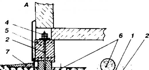
A carbon steel rod with a diameter of 20 mm, which passes through the grillage, is used as vertical reinforcement for the foundation column. The rod has a smooth surface covered with tar. At the bottom it is equipped with an ending embedded in the body of the post, and at the top with an ending protruding from the grillage and equipped with an M20 thread for a nut (RF patent No. 2221112 of 2002). The support itself is included in the grillage array by 4...6 cm (Figure 182, a).
After concreting, three or four cavities 0.6...0.8 m deep are made around each of the supports with the same foundation drill and filled with either sand, or a mixture of sand and expanded clay, or slag. In sandy soil such cavities need not be made.


Figure 182. Seismic isolating foundation with a central rod:
A – neutral position of the foundation support; B – deflected position of the foundation support;
1 – support; 2 – rod; 3 – lower end; 4 – nuts; 5 – grillage; 6 – cavity with sand; 7 – blind area; 8 – directions of ground vibrations
Upon completion of construction, the rod nuts are tightened with a torque wrench. This creates an “elastic” hinge in the area where the pillar meets the grillage.
During horizontal vibrations of the soil, the pillars deviate relative to the elastic hinge, the rod stretches, while the grillage with the building remains motionless by inertia (Figure 182, b). The elasticity of the soil and rods returns the pillars to their original vertical position. During the entire life of the building, free access to the pole reinforcement tensioning units must be provided both along the outer perimeter of the house and under the internal load-bearing walls. After completion of construction and after significant seismic vibrations, the tightening of all nuts is restored with a torque wrench (M = 40 - 70 kg/m). This version of the Seismic Isolating Foundation can be considered to some extent industrial, since it includes rods and nuts, which are easier to produce in production.
TISE technology provides for the implementation of seismic isolating supports in a more democratic way, accessible to developers with limited production capabilities. As a reinforcing elastic element, two brackets from a reinforcement bar with a diameter of 12 mm with bent ends are used (Figure 183). The middle part of the reinforcement branches, over a length of about 1 m, is lubricated with tar or bitumen (at an equal distance from the edges) to prevent adhesion of the reinforcement to the concrete. During seismic vibrations of the soil, the reinforcement bars in their middle part stretch. With horizontal soil displacements of 5 cm, the reinforcement stretches by 3...4 mm. With a tensile zone length of 1 m, stresses of 60...80 kg/mm² arise in the reinforcement, which lies in the zone of elastic deformations of the reinforcement material.


Figure 183. Seismic isolating foundation with reinforcement brackets:
1 – support; 2 – bracket; 3 – grillage; 4 – cavity with sand
When building a house in seismically active zones, waterproofing is not done at the connection between the grillage and the walls (to prevent their relative displacement). Using TISE technology, waterproofing is performed at the junction of the grillage with the foundation pillars (two layers of roofing material on bitumen mastic).
When constructing adjacent structures, porches, blind area elements, etc., you should constantly pay attention to ensure that the foundation strip does not touch them with its side surface. The gap between them should be at least 4 - 6 cm. If necessary, such contact is allowed (with the porch, the frame of light panel extensions, verandas) from the consideration that after destruction by an earthquake they will be restored.
This is not the foundation, but...
When building in seismically active areas, the use of roofing made of clay or sand concrete tiles must be justified.
Many Japanese individually built houses with a light frame are covered with high-quality clay tiles. In conditions of dense Japanese buildings, such houses can withstand typhoons well. However, during an earthquake, under the weight of the tiled roof, the house collapses, burying the inhabitants under its excessive weight.
Currently, many “light” roofing materials that closely imitate tiles have appeared on the construction market. Light roofing means minimal inertial loads for connecting the roof to the walls and preventing the roof from collapsing due to its excess weight.
As you already know, most city residents live in three main types of houses: small-block, large-block, large-panel. Frame-panel buildings are, as a rule, public and administrative. Let's try to imagine an earthquake situation for each of these houses.

So, you are in a small block house. The seismicity deficit of such an unfortified house is 1.5-2 points. We only note that cracks in internal and external walls can range from hairline to 3-4 centimeters. A commission of specialists observed cracks of this size, through which the street was visible, in similar houses in the city of Leninakan after the Spitak earthquake. There is no need to panic at the sight of such violations, because the house is designed for this. You should be especially careful if the damage is very different from what we have described. For example, there will be a shift of ceilings from the walls by 3 or more centimeters. rice. 5 What elements of the house best withstand the elements?

Let us turn to Figure 5, which shows the most typical layout of a residential 2-5-story small-block building. Load-bearing (on which the floors rest) main walls 1,2 are damaged less than transverse walls 3,4,5. The latter are easier to move (cut) by horizontal seismic forces, since they are less loaded. End wall 4, which is connected to the other walls on only one side, is considered especially dangerous. Sometimes the ends of buildings even come off the building and fall out, which was repeatedly observed in the village of Gazli, the cities of Spitak and Neftegorsk. The corner of building 6, which is least connected to the building and is most susceptible to “loosening” during an earthquake, is very dangerous. Already with a 7-8 magnitude earthquake, the corners of buildings on the top floor are usually damaged, and with a 9-magnitude earthquake they can fall out. It is not recommended to be near the external longitudinal walls (1) during an earthquake, since glass can “shoot out” here, windows can fall in and out (this remark is true not only for small-block houses), and in particularly weak houses they can even tear off (longitudinal walls from transverse ones) ). The safest places during an earthquake are the intersections of internal load-bearing longitudinal walls (2) with internal transverse ones. The figure shows the most typical “safety islands”: at the exits from apartments to the staircase and at the intersection wall 5. In these places, due to the cross-shaped intersection of load-bearing and non-load-bearing walls, a core of increased strength is created, which can withstand even the collapse of other walls. This core is stronger the fewer doorways it contains. So, for example, the most reliable place will be at the right three-room apartment in the area of the intersection of internal walls 2 and 5. Also reliable seems to be an island in a two-room apartment at the intersection of blind sections of walls type 3 and 2. As for the one-room and left three-room apartments, they have cores They have one or two openings and are therefore considered less durable than cores with blank walls. Therefore, if necessary, you can move here along wall 2. In such houses, built in the 70-80s. the doorways opening onto the staircase are framed with reinforced concrete frames, which guarantees their strength. However, in houses of earlier construction there are not frames everywhere, so these exits cannot be considered completely safe. Some general tips on behavior. As soon as an earthquake begins, you should open the doors leading to the landing and go to the traffic island. It's worth trying to run out of the building if you're on the first or second floor. From a higher floor, you may not be able to do this before serious damage begins. You need to run out of the house especially quickly and carefully so that you are not “covered” by bricks flying from the roof from destroyed pipes, or crushed by a heavy canopy. If you did not make it to the traffic island, you should remember that partitions made of small block masonry are very dangerous. They are among the first to be destroyed, even to the point of collapse. Wooden panel partitions are less dangerous, but quite large pieces of plaster can fall off from them, which are especially dangerous for small children. It is easy to distinguish a stone partition from a panel partition by the dull, very short, non-vibrating sound when hitting the wall with a fist. When arranging furniture in the apartment, make sure that bulky furniture cannot fall onto the safety island or onto a possible escape route from the apartment.

Many residents of big block homes know that their homes can withstand earthquakes quite well. Their actual seismic resistance is estimated by experts at 7.7 points.

In Fig. Figure 6 shows a typical layout of a large-block house. The position of the main load-bearing and non-load-bearing walls is the same as in a small-block house. A large-block house loses its load-bearing capacity mainly due to the separation of the walls into separate blocks, which in old-built houses, unfortunately, do not have a good connection with each other. The external walls consist of two blocks according to the height of the floor: a wall with a height of 2.2 m and a lintel with a height of 0.6 m. The internal walls consist of blocks with a floor height, i.e. 2.8 m. Reinforced concrete floors with a thickness of 0.22 m are supported on the lintel blocks of external walls and directly on the blocks of internal walls. During an earthquake with a magnitude greater than 7, the blocks begin to shift out of the plane of the wall. The greatest cracks and damage to joints (11) should be expected in non-load-bearing transverse walls that are less loaded with slabs, especially in the end wall (4) and staircase walls (3). In the last walls there is a small connection between the blocks with the help of not very strong metal plates, which even during an earthquake of 7.5-8 points will begin to become very loose, breaking off pieces of concrete and plaster around them. These debris can injure people running up the stairs, so it is necessary to move closer to the railings. rice. 6. As in small-block buildings, the corners of the building are very dangerous (6), especially on the upper floors. Shift of blocks from the plane of the wall can lead to partial collapse of the end wall (4) and floor slabs. The partitions in these houses, as a rule, are wooden, panel, plastered, and you should not be afraid of their collapse. Injury, especially to a small child, can be caused by pieces of plaster falling off the partitions and pieces of cement mortar falling out of the seams between the floor slabs. Such damage occurs during an earthquake of magnitude 7.5. The figure shows the safest places in a large-block house. Unlike small-block buildings, here all the exit doors to the staircase landing are reinforced with reinforced concrete frames (9), so the likelihood of the doors jamming due to misalignment is low and the exit from the apartment is quite reliable. To the general advice - do not hang heavy shelves in the area of the safety island and secure furniture, it should be added that this is especially important to do in the pantry closet (7) and in the corridor (8), otherwise there will simply be no room left for you on the safety island.

In old large-panel five-story residential buildings, the typical layout of which is shown in Fig. 7, the area of the traffic islands is already much larger. Despite the fact that these houses were designed for 7-8 points, practice has shown that their actual seismic resistance is close to 9 points. Not a single such building was destroyed anywhere during earthquakes in the territory of the former Soviet Union. All external and internal walls in such houses are large reinforced concrete panels, well connected at the nodes using embedding and welding (node 5). Internal walls and partitions are connected to each other using welded outlets. The floor panels are the size of a room, rest on the walls on four sides and are also connected to the walls by welding. The result is a reliable honeycomb structure. Calculations of the behavior of a large-panel house during a 9-magnitude earthquake showed that the greatest damage is expected in the corners of the building (6), and in the junctions of the end panels (4), where large vertical cracks of 1-2 cm can open. The first cracks may appear already at L-7.5 points. The same cracks may appear at expansion joints between buildings. But these cracks do not affect the overall stability of the building. Unpleasant factors include the possible appearance of inclined cracks up to 1 cm wide in reinforced concrete lintels above the entrance doors to apartments, which can lead to jamming of the doors. Therefore, they must be closed immediately when vibrations begin with a force of 6 points or more. Since large-panel buildings are quite reliable, you should not run out of them during an earthquake. But during an earthquake, it is recommended to stay in the area of safety islands, away from the outer walls, where window panes can “shoot out,” and from the end wall, in the nodes of which long, frightening cracks may open. You should not run out also because in the old houses of this series there are very heavy, dangerous canopies over the entrances to the entrances. Embedded metal parts with which these canopies were attached to the building. due to aging, they are heavily rusted and may not hold them up during strong seismic shocks.

During the earthquake on the island. In Shikotan in 1994, several canopies fell near similar large-panel three-story houses, which crushed two residents who were running out of one house. However, not a single person remaining in the house was injured. The house itself received no serious damage. Later large-panel houses, the so-called “improved” series, with bay windows, as well as houses of a “new” layout with large glazed balconies, were initially designed for 9 points and it is practically safe to be in them during an earthquake of such force. You need to beware of broken glass falling from above, especially from balconies, which can fly over long distances - up to 15 meters. Therefore, it is not recommended to run out of these houses, as well as to be on the street next to them. Fig. 7 Experience shows that even with strong 8-9 magnitude earthquakes, 1-2-story wooden houses practically do not collapse until they collapse. One of the authors of the book observed the behavior of panel and block houses during a 9-magnitude earthquake on the island. Shikotane. Of the nearly fifty two-story houses surveyed, there was not a single house where at least one wall had collapsed or the ceiling had failed. There were cases when the foundation “teared out” from under the house and was carried away by a landslide of 1-1.5 meters, and the house, sagging, stood! There were breaks in the walls in the corners of up to 20 cm and subsidence of the ground under the building up to 0.5 m, but the houses survived. Therefore, you should not run out of such houses, especially since bricks falling on those running out from collapsing chimneys pose a danger. In wooden houses, ceilings sway more than others and walls “crack”, which causes unpleasant sensations. Pieces of plaster may fall out of the walls and ceiling. Therefore, in such houses it makes sense to choose a place where the plaster fits tightly to the wall or ceiling, that is, it does not “bounce” in advance when tapped. It is better for children to hide under the table. And, of course, you need to stay away from external walls with windows, from heavy cabinets and shelves, especially if they are not specially secured. This is a general rule for any building.
Home training. Let's do a thought experiment. Close your eyes and imagine lying in your own bed. Imagine that at this moment the first strong seismic shock has occurred. Now mentally try to get to the door as quickly as possible, open it and take a place in the doorway. At the same time, bend your fingers in each case when, during your mental progress, you come across obstacles that actually exist. Now do the math. Each obstacle is at least 3 lost seconds. Estimate the time of pure movement and the time of opening the door lock. Add a few seconds to grab your backpack with documents and groceries (of course, it hangs next to the door, as recommended). And if you get more than 20 seconds, then give yourself a fat FAIL and let's get down to reorganizing. Make a list of obstacles discovered during the experiment. This is the minimum that needs to be done. Let's start moving in reverse order. Evaluate the door lock in terms of its ability to quickly open the door. Is it easy for you to find the lock itself and its opening device even in the dark? How many steps are required to unlock the lock and door? Try to arrange everything in such a way that the lock opens with a minimum of movements, and bring these movements to automaticity. Inspect the area around the front door. Are there objects nearby that, at the first push, could fall and block your path? If there are any, either strengthen them or find a more suitable place for them in the apartment. The corridor should be as free as possible. Very often, the passage is cluttered with things that have only recently been brought into the apartment and have not yet found their permanent place. Everyone knows that there is nothing more permanent than temporary. Therefore, without delaying “for later,” clear the path to salvation for yourself. Make sure that there are no objects along the walls that could be caught on. Look at your feet to see if shoes that are not currently in use have been removed from the corridor and if they are not creating obstacles to movement. Now let's turn our attention to the door from the corridor to the room. It is advisable that it be constantly open. Think about how you can lock it in the open position and install a latch. If there is carpet on the floor or there are tracks, then check how tightly they fit to the floor, whether there are any gathers, folds, or burrs. Does the track slip on the main floor covering? Pay special attention to the joints of carpets and paths. Eliminate all flaws, let the path be “silk”. In recent years, mobile interior elements have firmly entered our everyday life: tables on wheels, mobile TV stands, video and audio equipment. Make it a rule not to leave them in the evening along a possible escape route. Leave them in such a position that their spontaneous movement in the event of seismic shocks cannot occur in the direction of this escape route and does not cause objects or furniture to fall onto this route. If you use extension cords to connect electrical equipment, make sure that the wires do not cross the path of your movement to the outlet. The pride of almost every family is its home library. Check to see if books are on open shelves, from which they could fall at your feet at the first seismic shock or fall on your head when you run to the door. Evaluate items on open shelves from the same perspective, especially if these shelves are located above the doors. Make sure the shelves themselves are secured securely. Bedside tables should also be securely fastened so as not to be the first insurmountable barrier to salvation. It is advisable to fix the table lamps standing on these cabinets. If the drawers in these bedside tables easily fall out or open when the door is gently pushed, then make sure that they are securely fixed. Clothes that periodically accumulate next to the bed can be a serious obstacle to rapid movement. Make it a rule to put away things that you will not wear that day. (It turns out that a possible strong earthquake is an important reason to keep your house in order!)
Think back to the thought experiment you conducted and pay attention to which obstacle came your way first. If it is resolved, check to see if there are still unresolved barriers on your post-experiment list and take appropriate action. Now check the exit path for each family member. If the family has small children and you move towards them first, then pay attention to those areas that you will have to cross twice in different directions. Find out if your first movement will create obstacles to the return journey. Similarly, inspect and arrange the escape route from the living room and kitchen. Please note that several people, including children, can move from these rooms at the same time. When you watch athletics competitions, while watching a steeplechase race, you often have a desire to make the path easier for the athletes and remove obstacles and a pit of water. How easily and beautifully they would reach the finish line. But the rules of the game there do not allow this. The seismic safety rules, on the contrary, tell us - don’t let things get to the point of a home steeplechase, otherwise you won’t be able to get to the finish line safely. Therefore, we advise you to remove barriers from the road and not take unnecessary risks.
Excerpt from the work of V.N. Andreeva, V.N. Medvedev “SEISMIC RISK PROBLEMS IN THE REPUBLIC OF SAKHA (YAKUTIA)” without author’s illustrations.
Killer houses on the disaster map
An alarming trend was revealed by the latest Maps of general seismic zoning of the territory of the Russian Federation: compared with previous calculations, the number of regions with increased seismic hazard has increased significantly.
The planet continues to show its violent character. Earthquakes occur there with amazing regularity. In just two weeks there were 15 of them - in Turkey and Mexico, Sakhalin and Kamchatka, Los Angeles and Alaska, the Caucasus and Taiwan, the Ionian Sea and Japan. Fortunately, this time the tremors were not the strongest - their maximum intensity did not exceed 6.2 points, but they also led to destruction and loss of life. But a strong earthquake can become an economic and social disaster for an entire country; just remember the tragedy in India on January 26 last year.
In recent decades, the danger of seismic disasters has increased sharply, which is primarily due to human economic activity, technogenic impacts on the earth’s crust - the creation of reservoirs, the extraction of oil, gas, solid minerals, the injection of liquid industrial waste and a number of other factors. And the possible destruction of large engineering structures built on the surface (nuclear power plants, chemical plants, high-rise dams, etc.) can lead to environmental disasters. An example of such a potential danger is the Balakovo Nuclear Power Plant, which can withstand an earthquake no stronger than magnitude 6, despite the fact that the Saratov region today is classified as a zone of magnitude seven seismicity.
Almost no strong underground shock passes without leaving a trace: after each, the expected seismic hazard in the affected and adjacent regions increases. For example, the earthquake in Neftegorsk in 1995 was assessed by experts as 9-10 points. But back in the 60s, this and the surrounding areas were not considered seismically dangerous at all, and the possibility of earthquakes was not taken into account when designing buildings. The same underestimated forecasts of seismic activity were made in Japan, China, Greece and other countries. Unfortunately, similar errors cannot be ruled out in the future.
So the sad list of regions where the earth can suddenly stand on end is constantly growing. The latest Maps of general seismic zoning of the territory of the Russian Federation clearly demonstrate this. Until recently, two regions of Russia were considered the most seismically dangerous - Sakhalin, Kamchatka, the Kuril Islands and other areas of the Far East, as well as the territories of Eastern Siberia adjacent to the Baikal region and Transbaikalia, including the Altai Mountains. Catastrophic earthquakes with an intensity of 9 or more are possible there (up to 8.5 on the Richter scale). By the way, the territory of the Sakhalin region is among the most earthquake-prone not only in Russia, but also in the world.
Now, on the latest maps, the threat of earthquakes of magnitude 9 or more has spread to a significant part of the North Caucasus, where about 7 million people live. And this despite the fact that until recently the construction of residential buildings and industrial buildings was carried out here taking into account seismicity of 7 points. The greatest concern is in the Krasnodar region with a population of five million. In the summer months, on a narrow strip of the Black Sea coast, the number of people increases many times over.
Another very important difference between the new maps is that zones of magnitude 10 earthquakes appeared on them for the first time. They are located in Sakhalin, Kamchatka and Altai. Previously, such areas did not exist in our country.
But the exact location, strength and time of the earthquake is impossible to predict. There are no ways to prevent a cataclysm. The main task is to minimize destruction and loss of life. The latest strong earthquakes in Neftegorsk (1995), Turkey and Taiwan (1999) showed that fundamentally new approaches are needed in the regulation and design of engineering structures.
In the meantime, experts are coming to shocking results: the main “killers” of people during earthquakes are two types of buildings. And the most common ones. First of all, houses with walls made of low-strength materials. The second type is reinforced concrete frame buildings, the massive destruction of which was completely unexpected, since until recently they were one of the first places in terms of seismic resistance. Thus, during the earthquake in Leninakan, 98 percent of reinforced concrete frame houses collapsed like an accordion, and more than 10 thousand people died in them.
In contrast to frame buildings, large-panel buildings and houses with walls made of monolithic reinforced concrete, which have maximum rigidity in all directions, have proven themselves very well.
Of course, a radical solution to the current situation: the demolition of all dangerous houses and the construction of new ones in their place is unrealistic today. Therefore, the most difficult and urgent task is to strengthen buildings built without taking into account possible seismic effects or designed for minor earthquakes. Unfortunately, in Russia this problem is extremely acute. It is not for nothing that in the Federal Target Program “Seismic Safety of the Territory of Russia”, which began to operate this year, there is a terrible phrase: “In the entire history of the USSR and the Russian Federation, national seismic safety programs have not been implemented in the country, as a result of which tens of millions of people live in earthquake-prone areas in houses characterized by a seismic resistance deficiency of 2-3 points.” At the same time, in a number of constituent entities of the Russian Federation, even according to rough estimates, from 60 to 90 percent of buildings and other structures should be classified as non-seismic resistant.
According to the Program, more than half of the territory of Russia may be affected by earthquakes of medium magnitude, which can lead to severe consequences in densely populated areas, and “about 25 percent of the territory of the Russian Federation with a population of more than 20 million people may be subject to earthquakes of magnitude 7 or higher.
It is precisely taking into account the high seismic hazard, population density, and the degree of actual seismic vulnerability of buildings that the constituent entities of the Russian Federation were classified depending on the seismic risk index and divided into 2 groups.
The first group (see table) included 11 constituent entities of the Russian Federation - regions of the highest seismic risk. Many cities and large settlements in these regions are located in areas with seismicity of 9 and 10 points.
The second group included the Altai, Krasnoyarsk, Primorsky, Stavropol and Khabarovsk territories, the Amur, Kemerovo, Magadan, Chita regions, the Jewish Autonomous Region, the Ust-Orda Buryat, Chukotka and Koryak autonomous districts, the republics of Sakha (Yakutia), Adygea, Khakassia, Altai and the Chechen Republic. In these regions, the predicted seismic activity is 7-8 points and below.
Moscow and the Moscow region, according to the Russian Academy of Sciences, are not a seismically dangerous area. The maximum possible fluctuations here will not exceed 5 points.
Alexander Kolotilkin
High risk area
| Region | Seismic risk index * | Large cities (number of objects requiring priority strengthening) |
|---|---|---|
| Krasnodar region | 9 | Novorossiysk, Tuapse, Sochi, Anapa, Gelendzhik (1600) |
| Kamchatka region | 8 | Petropavlovsk-Kamchatsky, Elizovo, Klyuchi (270) |
| Sakhalin region | 8 | Yuzhno-Sakhalinsk, Nevelsk, Uglegorsk, Kurilsk, Aleksandrovsk-Sakhalinsky, Kholmsk, Poronaysk, Krasnogorsk, Okha, Makarov, Severo-Kurilsk, Chekhov (460). |
| The Republic of Dagestan | 7 | Makhachkala, Buynaksk, Derbent, Kizlyar, Khasavyurt, Dagestan Lights, Izberbash, Kaspiysk (690) |
| The Republic of Buryatia | 5 | Ulan-Ude, Severobaikalsk, Babushkin (485) |
| Republic of North Ossetia-Alania | 3,5 | Vladikavkaz, Alagir, Ardon, Digora, Beslan (400) |
| Irkutsk region | 2,5 | Irkutsk, Shelekhov, Tulun, Usolye-Sibirskoye, Cheremkhovo, Angarsk, Slyudyanka (860) |
| Kabardino-Balkarian Republic | 2 | Nalchik, Prokhladny, Terek, Nartkala, Tyrnyauz (330) |
| Ingush Republic | 1,8 | Nazran, Malgobek, Karabulak (125) |
| Karachay-Cherkess Republic | 1,8 | Cherkessk, Teberda (20) |
| Tyva Republic | 1,8 | Kyzyl, Ak-Dovurak, Chadan, Shagonar (145) |
_______
*The seismic risk index characterizes the required amount of anti-seismic reinforcements, takes into account seismic hazard, seismic risk and population in large populated areas.